Enable Location

We need your location to show you interesting places around you

Discover nearby places

Find interesting locations and hidden gems around you

Precise directions

Get accurate directions and distances to places

Your location is never shared with other users. It's only used when you tap the location button.

Log in to your account

Start exploring — it's free

Trusted by 65,603 travelers worldwide

Continue with Google
Continue with Apple
or

We will send you a code to connect

By continuing, you accept our Terms and Conditions and our Privacy Policy

Check your inbox

We've sent a pincode in your inbox. Please enter the code below.

Pine Creek Wilderness
Discussion Reviews Photo
3.6k Popularity

Pine Creek Wilderness, Wilderness area in Cleveland National Forest, California, US.

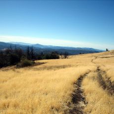
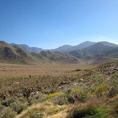
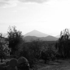
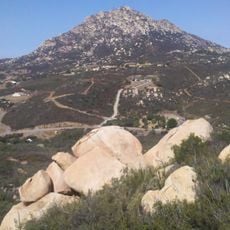
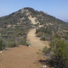
Pine Creek Wilderness is a federally protected wilderness area inside Cleveland National Forest in southern California, made up of chaparral scrub, steep canyons, and seasonal streams. The terrain rises from around 2,000 feet (600 m) to about 4,000 feet (1,200 m), with no roads or developed facilities inside its boundaries.

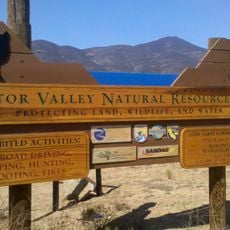
The US Congress designated this land as protected wilderness in 1984 and placed it under Forest Service management as part of a broader push to preserve wild lands across southern California. Before that, the area was largely unmanaged national forest land used informally by hikers and hunters.

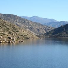
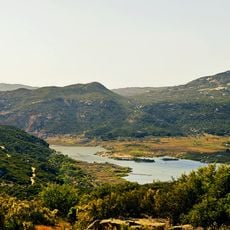
The name Pine Creek refers to the seasonal stream that runs through the area, lined with native pines at higher elevations. Hikers on the trails often spot mule deer and coyotes moving through the chaparral during the cooler hours of the day.

Groups are limited to 15 people and open fires are not allowed anywhere inside the wilderness, so a camp stove is worth bringing if you plan to stay overnight. Water sources inside are seasonal and unreliable, so carrying enough water for the full trip is important.

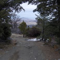
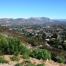
Horsethief Canyon, one of the drainages inside the wilderness, takes its name from a time when horse thieves reportedly hid stolen animals in its steep walls to avoid capture. The name has stuck for well over a century and gives the trail a bit of local history to think about along the way.

The community of curious travelers

AroundUs brings together thousands of curated places, local tips, and hidden gems, enriched daily by 60,000 contributors worldwide.

Start exploring
GPS coordinates
32.76644,-116.59804
Latest update
March 3, 2026 14:00
Around this place
Cuyamaca Rancho State Park
United States of America

Cuyamaca Rancho State Park

19.5 km
Blackjack Hall of Fame
United States of America

Blackjack Hall of Fame

32.2 km
Skyline Church
United States of America

Skyline Church

33.3 km
Cuyamaca Peak
United States of America

Cuyamaca Peak

20.1 km
Marshal Scotty's Playland Park
United States of America

Marshal Scotty's Playland Park

28.1 km
San Vicente Reservoir
United States of America

San Vicente Reservoir

34.6 km
Mount Laguna Observatory
United States of America

Mount Laguna Observatory

18 km
Lower Otay Reservoir
United States of America

Lower Otay Reservoir

34.3 km
Otay Mountain
United States of America

Otay Mountain

30 km
Pine Valley Creek Bridge
United States of America

Pine Valley Creek Bridge

7.2 km
Sawtooth Mountains Wilderness
United States of America

Sawtooth Mountains Wilderness

27.4 km
El Capitan Reservoir
United States of America

El Capitan Reservoir

23.8 km
San Miguel Mountain
United States of America

San Miguel Mountain

32.6 km
El Cajon Mountain
United States of America

El Cajon Mountain

26.5 km
Museum of Creation and Earth History
United States of America

Museum of Creation and Earth History

35 km
San Vicente Dam
United States of America

San Vicente Dam

34.5 km
Viejas Mountain
United States of America

Viejas Mountain

15.9 km
Barrett Dam
United States of America

Barrett Dam

11.9 km
Tecate Peak
United States of America

Tecate Peak

22.5 km
Loveland Dam
United States of America

Loveland Dam

18.4 km
La Posta Astro-Geophysical Observatory
United States of America

La Posta Astro-Geophysical Observatory

18.1 km
Lyons Peak
United States of America

Lyons Peak

17.1 km
McGinty Mountain
United States of America

McGinty Mountain

24.6 km
Morena Reservoir
United States of America

Morena Reservoir

10.8 km
Pacific Southwest Railway Museum Association
United States of America

Pacific Southwest Railway Museum Association

20.7 km
Creation & Earth History Museum & Bookstore
United States of America

Creation & Earth History Museum & Bookstore

34.9 km
Estación de Inspección de los Estados Unidos-Tecate
United States of America

Estación de Inspección de los Estados Unidos-Tecate

21.3 km
Jardín Ahorrador de Agua en el Cuyamaca College
United States of America

Jardín Ahorrador de Agua en el Cuyamaca College

32.1 km
Show the full map
Reviews
Share your experience

No review yet

Discussions
Start a discussion...

No discussion yet

« Pine Creek Wilderness - Wilderness area in Cleveland National Forest, California, US » is provided by Around Us (aroundus.com). Images and texts are derived from Wikimedia project under a Creative Commons license. You are allowed to copy, distribute, and modify copies of this page, under the conditions set by the license, as long as this note is clearly visible.

Discover hidden gems everywhere you go!

From secret cafés to breathtaking viewpoints, skip the crowded tourist spots and find places that match your style. Our app makes it easy with voice search, smart filtering, route optimization, and insider tips from travelers worldwide. Download now for the complete mobile experience.

Around Us App Screenshot

A unique approach to discovering new places

Le Figaro

All the places worth exploring

France Info

A tailor-made excursion in just a few clicks

20 Minutes

Around Us
Travel Guide & Maps
Download

Send to your phone

QR Code
1

Open the camera app on your mobile.

2

Point at the QR code with your camera. A notification will appear.

3

Tap the notification to open the link.