Cook Island Aquatic Reserve, Marine reserve near Fingal Head, Australia
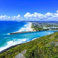
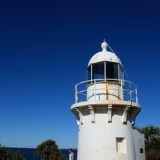
Cook Island Aquatic Reserve protects the waters within 500 metres of a survey marker on Cook Island, about 600 metres off Fingal Head, New South Wales. Declared on 23 October 1998, it covered 74 hectares as of 2016. A no-fishing zone runs from the island's mean high water mark to a line of five marker buoys, with line fishing permitted beyond.
The New South Wales government established this marine protected area in 1998 under the Fisheries Management Act. This step was taken to preserve marine biodiversity in the region for the future.
Cook Island was named Turtle Island by two men from John Oxley's crew in 1823, after they landed and found sea turtles there; they also reported an unidentified shipwreck. Five years later Admiral Henry John Rous, who charted the Tweed River, called it Cook's Isle, the name it keeps today.
The reserve lies within 500 m of a survey marker on Cook Island, about 600 m off Fingal Head. Fishing is banned from the island's mean high water mark out to a line of five marker buoys; line fishing is allowed from those buoys to the outer boundary. Thirteen moorings let boats tie up instead of anchoring.
In 1823 John Oxley anchored off the island for shelter from strong southerly winds; two of his crew landed and named it Turtle Island after finding sea turtles there, and also reported an unidentified shipwreck. Five years later Admiral Henry John Rous, who charted the Tweed River, called it Cook's Isle, the name it keeps today.
The community of curious travelers
AroundUs brings together thousands of curated places, local tips, and hidden gems, enriched daily by 93,020 contributors worldwide.