Chest opened
+${chestReward.xp} XP
Explorer
NOUVEAU ×${chestReward.collectible.quantity}
tapez pour fermer
Chest locked

Open chests in the app

Around Us is built for your phone — chests unlock when you walk, explore and capture nearby places.

Enable Location

We need your location to show you interesting places around you

Discover nearby places

Find interesting locations and hidden gems around you

Precise directions

Get accurate directions and distances to places

Your location is never shared with other users. It's only used when you tap the location button.

Log in to your account

Start exploring — it's free

Trusted by 72,877 travelers worldwide

Continue with Google
Continue with Apple
or

We will send you a code to connect

By continuing, you accept our Terms and Conditions and our Privacy Policy

Check your inbox

We've sent a pincode in your inbox. Please enter the code below.

Table Top Mountain
Discussion Reviews Photo
1.3k Popularity

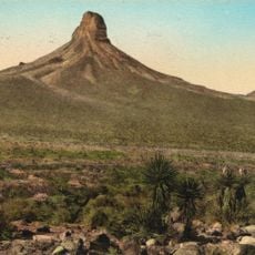
Table Top Mountain, Desert summit in Sonoran Desert National Monument, Arizona

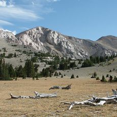
Table Top Mountain is a desert peak with a broad, level summit in the Sonoran Desert National Monument east of Phoenix. The mountain rises from sandy flats and rocky terrain, with its distinctive plateau shape visible from many directions across the valley.

The mountain gained federal protection status in 1990 when Congress established the Sonoran Desert National Monument as part of broader desert conservation efforts. This protection reflected growing recognition of the region's ecological and geological value.

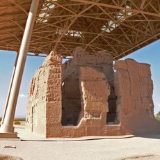
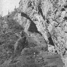
The mountain features ancient stone walls near its summit plateau, built without mortar by previous inhabitants of this Sonoran Desert region.

The hike to the summit is demanding and requires sturdy boots plus generous water supplies, especially in hot months. Starting early in the day or later in the afternoon helps you avoid the peak desert heat.

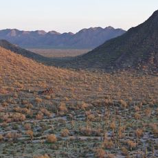
The summit plateau supports an unexpected grassland pocket, completely surrounded by saguaro cacti and desert brush. This isolated ecosystem creates a green contrast against the typical desert landscape that visitors find striking.

The community of curious travelers

AroundUs brings together thousands of curated places, local tips, and hidden gems, enriched daily by 60,000 contributors worldwide.

Start exploring
GPS coordinates
32.76917,-112.14222
Latest update
December 14, 2025 17:00
Around this place
Basin and Range Province
United States of America

Basin and Range Province

28.9 km
Casa Grande Ruins National Monument
United States of America

Casa Grande Ruins National Monument

62.4 km
Sonoran Desert National Monument
United States of America

Sonoran Desert National Monument

44.7 km
Hohokam Pima National Monument
United States of America

Hohokam Pima National Monument

50.8 km
Corona Satellite Calibration Targets
United States of America

Corona Satellite Calibration Targets

37.7 km
Ventana Cave
United States of America

Ventana Cave

47.4 km
Isanaklesh Peaks
United States of America

Isanaklesh Peaks

32.5 km
Mesquite Groves Aquatic Center
United States of America

Mesquite Groves Aquatic Center

61.5 km
Gatlin Site
United States of America

Gatlin Site

57.6 km
C.H. Cook Memorial Church
United States of America

C.H. Cook Memorial Church

50.9 km
United States of America

Gu Achi Peak

53.1 km
Casa Grande Stone Church
United States of America

Casa Grande Stone Church

38.3 km
First Baptist Church
United States of America

First Baptist Church

38.7 km
Casa Grande Woman's Club Building
United States of America

Casa Grande Woman's Club Building

38.2 km
Saint Anthony's Church
United States of America

Saint Anthony's Church

38.4 km
White House
United States of America

White House

39.1 km
Valley National Bank
United States of America

Valley National Bank

38.1 km
Cruz Trading Post
United States of America

Cruz Trading Post

38.1 km
Building at 400 East Third Street
United States of America

Building at 400 East Third Street

38.6 km
Henry and Anna Kochsmeier House
United States of America

Henry and Anna Kochsmeier House

37.7 km
Walter Wilbur House
United States of America

Walter Wilbur House

39.4 km
Casa Grande Hospital
United States of America

Casa Grande Hospital

38.9 km
The Domes of Casa Grande
United States of America

The Domes of Casa Grande

34.9 km
Sonic
United States of America

Sonic

40.7 km
Casa Grande City Hall
United States of America

Casa Grande City Hall

38.9 km
Paramount Theatre
United States of America

Paramount Theatre

38.4 km
Gila Bend Visitor Center and Museum
United States of America

Gila Bend Visitor Center and Museum

58.3 km
Stout's Hotel
United States of America

Stout's Hotel

57.2 km
Show the full map
Reviews
Share your experience

No review yet

Discussions
Start a discussion...

No discussion yet

« Table Top Mountain - Desert summit in Sonoran Desert National Monument, Arizona » is provided by Around Us (aroundus.com). Images and texts are derived from Wikimedia project under a Creative Commons license. You are allowed to copy, distribute, and modify copies of this page, under the conditions set by the license, as long as this note is clearly visible.

Discover hidden gems everywhere you go!

From secret cafés to breathtaking viewpoints, skip the crowded tourist spots and find places that match your style. Our app makes it easy with voice search, smart filtering, route optimization, and insider tips from travelers worldwide. Download now for the complete mobile experience.

Around Us App Screenshot

A unique approach to discovering new places

Le Figaro

All the places worth exploring

France Info

A tailor-made excursion in just a few clicks

20 Minutes

Around Us
Travel Guide & Maps
Download

Send to your phone

QR Code
1

Open the camera app on your mobile.

2

Point at the QR code with your camera. A notification will appear.

3

Tap the notification to open the link.