Cerro Hoya National Park, National park in Azuero Peninsula, Panama
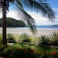
Cerro Hoya National Park covers 333.42 km² at the southwestern tip of the Azuero Peninsula, with about 20% of its area in the sea. Its three highest peaks, Cerro Hoya (1,559 m), Cerro Moya (1,534 m) and Cerro Soya (1,478 m), rise above roughly 80% of the park lying above 300 m. The coastal strip runs from the Ventana River mouth to the Restingue River mouth and includes Restingue Island, mangroves, coral reefs and cliffs.
Cerro Hoya National Park was created by decree No. 74 of 2 October 1984, one of Panama's early designation initiatives. The mountains are volcanic in origin and hold the oldest rocks known in the Isthmus of Panama, dating from the Upper Cretaceous and Paleocene, when an island chain linked the Nicoya and Osa peninsulas of Costa Rica with Azuero. From 1994 to 2004 the German GTZ ran a bilateral project here combining conservation goals with better living conditions for local residents.
Around 25 settlements lie inside the park, and the rivers rising there, including the Tonosí and Guánico, feed farmland downstream. From 1994 to 2004 the German GTZ ran a bilateral project here that combined strengthening conservation goals with improving local living conditions.
Hiking requires a guide familiar with the terrain since trails lack markers and the ground is steep. The best time to spot animals is early morning, when wildlife is more active.
Scientists regularly find previously unknown species here, including frogs, lizards, and plants yet to be formally described. These ongoing discoveries make the park an active laboratory for biological research.
The community of curious travelers
AroundUs brings together thousands of curated places, local tips, and hidden gems, enriched daily by 93,607 contributors worldwide.