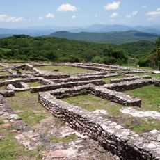
Teopantecuanitlan, Archaeological site in Guerrero, Mexico.
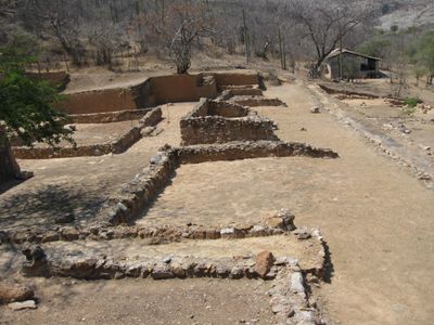
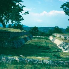
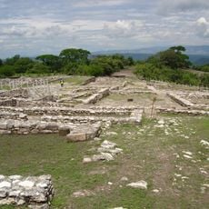
Teopantecuanitlan is an archaeological site in Guerrero, Mexico, spreading across two kilometers where the Amacuzac and Balsas rivers converge. The settlement contains residential compounds on stone foundations, ceremonial platforms, two ball courts, and an intricate system of irrigation channels carved into the terrain.
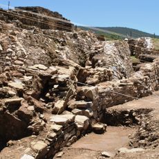
The site was occupied from around 1400 to 500 BCE, with its population peak occurring between 1000 and 800 BCE during the Early to Middle Formative Period. This flourishing time reveals how communities developed organized settlements and built lasting water management systems.
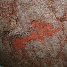
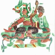
The Sunken Patio features carved travertine blocks with anthropomorphic designs that visitors can see up close, reflecting how people here tracked celestial events and seasons.
Visitors can move through the site along marked pathways that connect residential areas, ball courts, and ceremonial platforms. Informational signs throughout help orient you and explain what you are seeing at different locations.
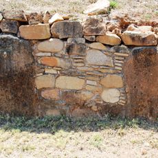
The grounds hold one of Mesoamerica's oldest known irrigation systems, built around 1200 BCE using rough stones and flat stone slabs. This engineering achievement shows how early peoples mastered water management techniques that sustained their farming.
GPS coordinates: 17.90167,-99.11056
Latest update: December 6, 2025 17:41
Guerrero brings together Pacific coastline, colonial towns, and archaeological sites from pre-Hispanic civilizations. The landscape ranges from sandy beaches and offshore islands to cave systems and waterfalls in the mountainous interior of the Sierra Madre del Sur. Taxco displays baroque churches...
Grutas de Cacahuamilpa National Park
95.3 km
Chalcatzingo
95.2 km
Mezcala Bridge
27.7 km
Coatetelco
94.7 km
Juxtlahuaca
51.7 km
Xochipala
56.9 km
Christ sculpture in Taxco de Alarcón
90.3 km
Tehuacalco
89.7 km
Oxtotitlán
21.5 km
Chilpancingo Cathedral
56.8 km
Co-Cathedral of the Assumption, Chilapa
35.2 km
Casa Borda
89.8 km
Cuetlajuchitlán
35.1 kmNexapa River
43.7 km
Ixcateopan
98 kmCañón del Zopilote
48.8 kmWilliam Spratling Museum
89.8 km
Museum of Religious Art Taxco, Casa Humboldt
89.7 km
Former headquarters Zapata
87.5 km
Jardín botánico Limontitla
96.4 km
Rancho Joan Sebastian Alejandra C V
87.8 km
William Spratling Museum
89.6 km
Monumento Patria Trigarante
66.2 km
Glorieta Las Alas
84.1 km
Pozas azules de Atzala
89.8 km
Cascada de Cacalotenango
93.7 km
Museo Interactivo "La Avispa"
58 km
Mausoleo Del General Emiliano Zapata
87 kmVisited this place? Tap the stars to rate it and share your experience / photos with the community! Try now! You can cancel it anytime.
Discover hidden gems everywhere you go!
From secret cafés to breathtaking viewpoints, skip the crowded tourist spots and find places that match your style. Our app makes it easy with voice search, smart filtering, route optimization, and insider tips from travelers worldwide. Download now for the complete mobile experience.
A unique approach to discovering new places❞
— Le Figaro
All the places worth exploring❞
— France Info
A tailor-made excursion in just a few clicks❞
— 20 Minutes