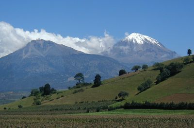
Sierra Negra, Extinct volcano in Puebla, Mexico
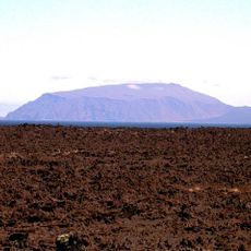
Sierra Negra is an extinct volcano in Puebla state that rises to 4580 meters and belongs to the volcanic chain of the Trans-Mexican Volcanic Belt. The dark rock at the summit stands in sharp contrast to the snow-covered neighbor Pico de Orizaba and forms the fifth-highest elevation in Mexico with a broad, flattened crater area at the highest point.
Indigenous peoples gave the mountain the name Tliltépetl, meaning Black Mountain and referring to the dark color of the volcanic rock. Scientists recognized the potential of the location for observatories in the 20th century and began constructing astronomical facilities at the higher elevations.
Local Nahuatl communities continue to use the name Iztactepetl Icni for the summit, which means Sibling of the White Mountain. This designation expresses the close connection to nearby Pico de Orizaba, considered its white twin and shaping the landscape together with this peak.
Visitors must apply for permission from park authorities at least seven days before the planned ascent, as access is controlled. The high altitude requires thorough acclimatization and suitable equipment for cold conditions, especially during early morning hours and in windy weather.
The summit hosts the Large Millimeter Telescope, the largest and most sensitive single-dish radio telescope of its kind worldwide. Scientists use the thin atmosphere and clear air at this elevation to study distant galaxies and cosmic structures that are difficult to observe from other locations.
The community of curious travelers
AroundUs brings together thousands of curated places, local tips, and hidden gems, enriched daily by 60,000 contributors worldwide.