Enable Location

We need your location to show you interesting places around you

Discover nearby places

Find interesting locations and hidden gems around you

Precise directions

Get accurate directions and distances to places

Your location is never shared with other users. It's only used when you tap the location button.

Cerro El Potosí

Log in to your account

Start exploring — it's free

Trusted by 62,090 travelers worldwide

Continue with Google
Continue with Apple
or

We will send you a code to connect

By continuing, you accept our Terms and Conditions and our Privacy Policy

Check your inbox

We've sent a pincode in your inbox. Please enter the code below.

Cerro El Potosí

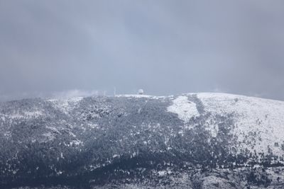
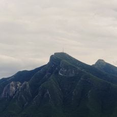
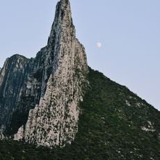
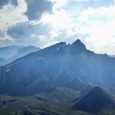
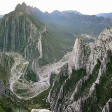
Cerro El Potosí, Summit in Sierra Madre Oriental, Mexico.

Cerro El Potosi is a summit in the Sierra Madre Oriental mountain range in northeast Mexico, reaching 3,721 meters (12,208 feet) in elevation and standing as the highest point in this range. A road built in the 1960s for a microwave relay station extends toward the upper slopes, offering hikers a more direct and less strenuous route to the top.

The mountain became a center for silver mining operations during the 18th century, driving significant economic growth in the Nuevo León region. These mining activities left a lasting mark on the area's development and importance over the centuries that followed.

The mountain holds deep meaning for nearby communities, serving as a symbol of regional identity and a place where local traditions remain part of daily consciousness. People in the area speak of it with respect and connection to their land and heritage.

The summit is accessible via a road that reaches the upper slopes, making the ascent feasible for most visitors without requiring technical climbing skills. Weather conditions can change quickly at higher elevations, so visitors should come prepared with appropriate gear and clothing for temperature shifts.

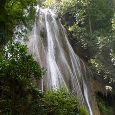
The upper slopes contain an ecological reserve established in 2000 that protects rare plant species including the Potosí Pinyon and other alpine flora found nowhere else. This protected area makes the mountain an important refuge for preserving these specialized mountain ecosystems.

The community of curious travelers

AroundUs brings together thousands of curated places, local tips, and hidden gems, enriched daily by 60,000 contributors worldwide.

Start exploring
GPS coordinates
24.87406,-100.23373
Latest update
December 6, 2025 16:04
Sacred landmarks in latin america

Latin America is home to many sacred places that are deeply rooted in the traditions and beliefs of the region. These sites blend ancient heritage with later religious influences, telling the story of different cultures that have overlapped over centuries. From old ruins to grand churches, these...

« Cerro El Potosí - Summit in Sierra Madre Oriental, Mexico » is provided by Around Us (aroundus.com). Images and texts are derived from Wikimedia project under a Creative Commons license. You are allowed to copy, distribute, and modify copies of this page, under the conditions set by the license, as long as this note is clearly visible.

Discover hidden gems everywhere you go!

From secret cafés to breathtaking viewpoints, skip the crowded tourist spots and find places that match your style. Our app makes it easy with voice search, smart filtering, route optimization, and insider tips from travelers worldwide. Download now for the complete mobile experience.

Around Us App Screenshot

A unique approach to discovering new places

Le Figaro

All the places worth exploring

France Info

A tailor-made excursion in just a few clicks

20 Minutes

Around Us
Travel Guide & Maps
Download

Send to your phone

QR Code
1

Open the camera app on your mobile.

2

Point at the QR code with your camera. A notification will appear.

3

Tap the notification to open the link.