Chest opened
+${chestReward.xp} XP
Explorer
NOUVEAU ×${chestReward.collectible.quantity}
tapez pour fermer
Chest locked

Open chests in the app

Around Us is built for your phone — chests unlock when you walk, explore and capture nearby places.

Enable Location

We need your location to show you interesting places around you

Discover nearby places

Find interesting locations and hidden gems around you

Precise directions

Get accurate directions and distances to places

Your location is never shared with other users. It's only used when you tap the location button.

Loch Dhu

Log in to your account

Start exploring — it's free

Trusted by 72,885 travelers worldwide

Continue with Google
Continue with Apple
or

We will send you a code to connect

By continuing, you accept our Terms and Conditions and our Privacy Policy

Check your inbox

We've sent a pincode in your inbox. Please enter the code below.

Discussion Reviews 1 Photos
1.4k Popularity

Loch Dhu, human settlement in South Carolina, United States of America

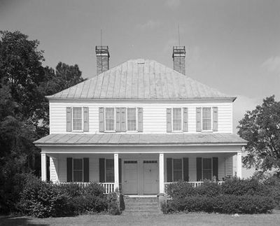
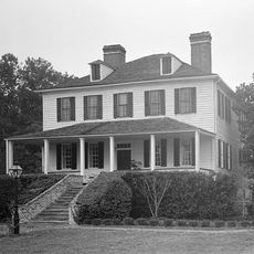
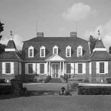
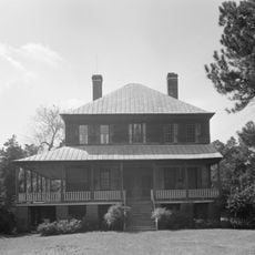
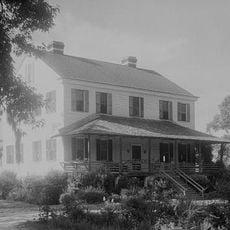
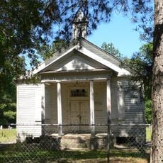
Loch Dhu is a house from the early 1800s built on a hillside in Berkeley County, South Carolina, with a straightforward design and practical layout. The two-story wooden building features a high hipped roof, two large front rooms each with its own entrance door and transom window, with a stair hall and smaller rooms behind them.

The house was likely built between 1812 and 1816 by Robert James Kirk, a landowner and farmer, whose family grew cotton, sweet potatoes, and corn on the property. His son Philip Kirk later served as a surgeon in the Confederate Army and used the house as a hospital for wounded soldiers during the Civil War.

The name Loch Dhu comes from Scottish Gaelic, meaning "black lake", taken from a small pond on the property. The simple layout with two front doors side by side was common in this region during the early 1800s and reflects the practical habits of plantation life at that time.

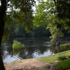
The house is privately owned and not open to the public; visitors must contact the owners in advance to request permission to visit. The property sits on a hill overlooking Lake Marion and is best explored during daylight to see the exterior architecture and the surrounding farm buildings.

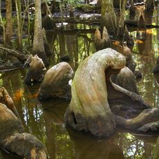
The house served as a field hospital during the Civil War and is known for reports of supernatural activity, including footsteps heard in hallways that visitors have claimed to hear over many decades. After the Santee-Cooper dams were built in the 1930s and flooded large areas, Loch Dhu survived because it sits on higher ground while neighboring lands submerged.

The community of curious travelers

AroundUs brings together thousands of curated places, local tips, and hidden gems, enriched daily by 60,000 contributors worldwide.

Start exploring
Location
GPS coordinates
33.39111,-80.21361
Latest update
February 9, 2026 08:18
Around this place
United States of America

Lake Marion

8.7 km
Mepkin Abbey
United States of America

Mepkin Abbey

39.2 km
Lewisfield Plantation
United States of America

Lewisfield Plantation

32.9 km
Medway
United States of America

Medway

46 km
Francis Beidler Forest
United States of America

Francis Beidler Forest

22.2 km
Mulberry Plantation
United States of America

Mulberry Plantation

33.2 km
Givhans Ferry State Park
United States of America

Givhans Ferry State Park

42.8 km
Santee National Wildlife Refuge
United States of America

Santee National Wildlife Refuge

17.4 km
Cypress Gardens
United States of America

Cypress Gardens

44.7 km
Biggin Church
United States of America

Biggin Church

30.4 km
Indian Fields Methodist Campground
United States of America

Indian Fields Methodist Campground

36.2 km
Santee Indian Mound and Fort Watson
United States of America

Santee Indian Mound and Fort Watson

26.5 km
Royal Lanes Family Entertainment Center
United States of America

Royal Lanes Family Entertainment Center

45.8 km
Providence Methodist Church
United States of America

Providence Methodist Church

30.4 km
Gippy Plantation
United States of America

Gippy Plantation

31.1 km
Kingstree Historic District
United States of America

Kingstree Historic District

46.7 km
Davis House
United States of America

Davis House

29.1 km
Summerton High School
United States of America

Summerton High School

26.8 km
Lawson's Pond Plantation
United States of America

Lawson's Pond Plantation

2.5 km
Cypress Methodist Camp Ground
United States of America

Cypress Methodist Camp Ground

32.1 km
Numertia Plantation
United States of America

Numertia Plantation

6.1 km
Pineville Historic District
United States of America

Pineville Historic District

24.4 km
J. Clinton Brogdon House
United States of America

J. Clinton Brogdon House

46.8 km
Manning Library
United States of America

Manning Library

34.4 km
William Robertson House
United States of America

William Robertson House

24.2 km
Taveau Church
United States of America

Taveau Church

40.7 km
Manning Commercial Historic District
United States of America

Manning Commercial Historic District

33.9 km
St. Paul's Church
United States of America

St. Paul's Church

42.1 km
Show the full map
Reviews
Share your experience

No review yet

Discussions
Start a discussion...

No discussion yet

« Loch Dhu - human settlement in South Carolina, United States of America » is provided by Around Us (aroundus.com). Images and texts are derived from Wikimedia project under a Creative Commons license. You are allowed to copy, distribute, and modify copies of this page, under the conditions set by the license, as long as this note is clearly visible.

Discover hidden gems everywhere you go!

From secret cafés to breathtaking viewpoints, skip the crowded tourist spots and find places that match your style. Our app makes it easy with voice search, smart filtering, route optimization, and insider tips from travelers worldwide. Download now for the complete mobile experience.

Around Us App Screenshot

A unique approach to discovering new places

Le Figaro

All the places worth exploring

France Info

A tailor-made excursion in just a few clicks

20 Minutes

Around Us
Travel Guide & Maps
Download

Send to your phone

QR Code
1

Open the camera app on your mobile.

2

Point at the QR code with your camera. A notification will appear.

3

Tap the notification to open the link.