Enable Location

We need your location to show you interesting places around you

Discover nearby places

Find interesting locations and hidden gems around you

Precise directions

Get accurate directions and distances to places

Your location is never shared with other users. It's only used when you tap the location button.

Interstate 580

Log in to your account

Start exploring — it's free

Trusted by 62,631 travelers worldwide

Continue with Google
Continue with Apple
or

We will send you a code to connect

By continuing, you accept our Terms and Conditions and our Privacy Policy

Check your inbox

We've sent a pincode in your inbox. Please enter the code below.

Interstate 580

Interstate 580, Interstate highway in Northern California, United States

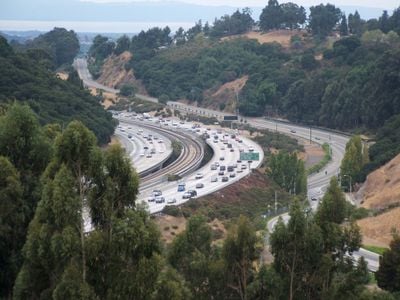
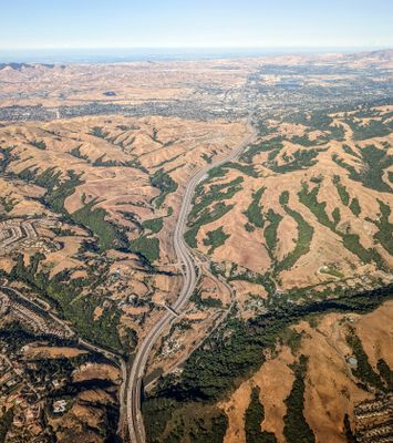
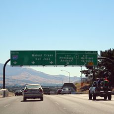
Interstate 580 is a 76-mile (122 km) highway connecting San Rafael to Tracy, crossing from the San Francisco Bay Area into California's Central Valley. The route passes over the Richmond-San Rafael Bridge and through Altamont Pass, linking multiple counties and regional transportation networks.

The route received its current interstate designation in 1964, consolidating earlier sections of U.S. Route 50 into a unified corridor. This merger of previous routes established a major link that coordinated traffic flow between the bay region and inland areas.

The MacArthur Freeway section earned recognition as the Most Beautiful Urban Highway in the United States from Nationwide Parade Magazine in 1966.

Westbound traffic on the bridge section must pay tolls via electronic FasTrak transponders. Trucks over 4.5 tons face restrictions and are directed to alternative routes including Interstate 238 and Interstate 880.

The Richmond-San Rafael Bridge segment collects tolls exclusively from westbound traffic, utilizing FasTrak transponders for electronic payment processing.

The community of curious travelers

AroundUs brings together thousands of curated places, local tips, and hidden gems, enriched daily by 60,000 contributors worldwide.

Start exploring
Location
Location
Inception
July 1, 1964
GPS coordinates
37.69781,-121.97708
Latest update
December 17, 2025 10:22
Around this place
Federal Correctional Institution, Dublin
United States of America

Federal Correctional Institution, Dublin

7.4 km
Interstate 680
United States of America

Interstate 680

4.8 km
Niles Canyon
United States of America

Niles Canyon

13.1 km
Sunol Water Temple
United States of America

Sunol Water Temple

14.9 km
Blackhawk Museum
United States of America

Blackhawk Museum

12.7 km
Eugene O'Neill National Historic Site
United States of America

Eugene O'Neill National Historic Site

15 km
Hacienda del Pozo de Verona
United States of America

Hacienda del Pozo de Verona

9.9 km
Quarry Lakes Regional Recreation Area
United States of America

Quarry Lakes Regional Recreation Area

13.7 km
Meek Mansion
United States of America

Meek Mansion

12 km
Golden Gate Railroad Museum
United States of America

Golden Gate Railroad Museum

12.3 km
Niles Essanay Silent Film Museum
United States of America

Niles Essanay Silent Film Museum

13.4 km
City Center Building
United States of America

City Center Building

9.5 km
Forest Home Farms
United States of America

Forest Home Farms

4.8 km
Pioneer Stadium
United States of America

Pioneer Stadium

8.7 km
Warren Hall
United States of America

Warren Hall

8.5 km
Alviso Adobe Community Park
United States of America

Alviso Adobe Community Park

7.1 km
Hayward City Hall
United States of America

Hayward City Hall

10 km
Vallejo Flour Mill
United States of America

Vallejo Flour Mill

13.4 km
Hayward Hall of Justice
United States of America

Hayward Hall of Justice

11.3 km
Don Castro Regional Recreation Area
United States of America

Don Castro Regional Recreation Area

6.5 km
Pioneer Amphitheatre
United States of America

Pioneer Amphitheatre

8.2 km
Holy Cross Orthodox Monastery
United States of America

Holy Cross Orthodox Monastery

7.5 km
Niles Depot Museum
United States of America

Niles Depot Museum

13.4 km
Doolan Canyon
United States of America

Doolan Canyon

13.5 km
Sunol
United States of America

Sunol

13.9 km
Museum on Main
United States of America

Museum on Main

9.8 km
Regal Hacienda Crossings Stadium 20 & IMAX
United States of America

Regal Hacienda Crossings Stadium 20 & IMAX

8.1 km
San Ramon Library
United States of America

San Ramon Library

7.7 km
Show the full map
« Interstate 580 - Interstate highway in Northern California, United States » is provided by Around Us (aroundus.com). Images and texts are derived from Wikimedia project under a Creative Commons license. You are allowed to copy, distribute, and modify copies of this page, under the conditions set by the license, as long as this note is clearly visible.

Discover hidden gems everywhere you go!

From secret cafés to breathtaking viewpoints, skip the crowded tourist spots and find places that match your style. Our app makes it easy with voice search, smart filtering, route optimization, and insider tips from travelers worldwide. Download now for the complete mobile experience.

Around Us App Screenshot

A unique approach to discovering new places

Le Figaro

All the places worth exploring

France Info

A tailor-made excursion in just a few clicks

20 Minutes

Around Us
Travel Guide & Maps
Download

Send to your phone

QR Code
1

Open the camera app on your mobile.

2

Point at the QR code with your camera. A notification will appear.

3

Tap the notification to open the link.