Enable Location

We need your location to show you interesting places around you

Discover nearby places

Find interesting locations and hidden gems around you

Precise directions

Get accurate directions and distances to places

Your location is never shared with other users. It's only used when you tap the location button.

Tower Bridge

Log in to your account

Start exploring — it's free

Trusted by 63,014 travelers worldwide

Continue with Google
Continue with Apple
or

We will send you a code to connect

By continuing, you accept our Terms and Conditions and our Privacy Policy

Check your inbox

We've sent a pincode in your inbox. Please enter the code below.

Discussion Reviews 1 Photos 1 Collections
17.7k Popularity

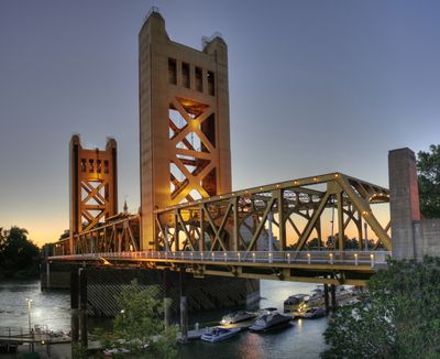
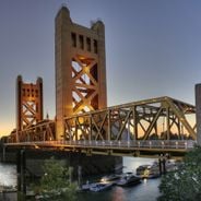
Tower Bridge, Vertical-lift bridge in Sacramento, United States

Tower Bridge is a vertical-lift bridge crossing the Sacramento River in the city of Sacramento in California. The two towers rise approximately 160 feet high and support a movable center span of around 209 feet, painted in a yellow-ochre shade.

Construction began in 1934 to replace an aging swing bridge that could no longer handle growing traffic volumes. The official opening took place on December 15, 1935, marking a turning point in the region's transportation development.

The name refers to the two tall towers that lift the central span when river vessels need to pass through. Today visitors often see the yellow structure illuminated at night, when it becomes a landmark for the city and appears on many postcards.

The bridge links West Capitol Avenue in West Sacramento with Capitol Mall in Sacramento through four traffic lanes. Pedestrians can walk along both sides and view the river and surrounding neighborhoods along the way.

During the opening ceremony in 1935, 1000 homing pigeons were released to spread news about the new crossing throughout California. The birds flew to different cities carrying small messages about this moment with them.

The community of curious travelers

AroundUs brings together thousands of curated places, local tips, and hidden gems, enriched daily by 60,000 contributors worldwide.

Start exploring
Location
Location
Official opening
December 15, 1935
GPS coordinates
38.58056,-121.50833
Latest update
December 5, 2025 22:30
Sacramento: visit the California capital, its museums and historical landmarks

Sacramento offers a journey through Californian history, from the 1849 Gold Rush to today. The Old Sacramento district retains its 1850 brick buildings and Victorian facades, while the California State Capitol overlooks the city with its 16-hectare gardens. The California State Railroad Museum...

Around this place
Old Sacramento Waterfront
United States of America

Old Sacramento Waterfront

373 m
Crocker Art Museum
United States of America

Crocker Art Museum

427 m
California State Railroad Museum
United States of America

California State Railroad Museum

596 m
I Street Bridge
United States of America

I Street Bridge

659 m
California State Library
United States of America

California State Library

1.2 km
Delta King
United States of America

Delta King

275 m
Ruhstaller Building
United States of America

Ruhstaller Building

1.3 km
United States of America

Weinstock's

556 m
Wells Fargo Center
United States of America

Wells Fargo Center

522 m
California Automobile Museum
United States of America

California Automobile Museum

1.2 km
California State Military Museum
United States of America

California State Military Museum

334 m
U.S. Bank Tower
United States of America

U.S. Bank Tower

841 m
Pony Express Terminal
United States of America

Pony Express Terminal

537 m
Renaissance Tower
United States of America

Renaissance Tower

1.1 km
Robert T. Matsui United States Courthouse
United States of America

Robert T. Matsui United States Courthouse

897 m
Big Four Building
United States of America

Big Four Building

500 m
Eagle Theatre
United States of America

Eagle Theatre

455 m
Sacramento History Museum
United States of America

Sacramento History Museum

561 m
Heilbron House
United States of America

Heilbron House

1 km
Bank of the West Tower
United States of America

Bank of the West Tower

699 m
Sacramento City Library
United States of America

Sacramento City Library

1.2 km
Jesse M. Unruh State Office Building
United States of America

Jesse M. Unruh State Office Building

1 km
Park Tower
United States of America

Park Tower

1.2 km
Towers on Capitol Mall
United States of America

Towers on Capitol Mall

439 m
Blue Anchor Building
United States of America

Blue Anchor Building

1.3 km
United States of America

Saint Andrews African Methodist Episcopal Church

1.1 km
Old Sacramento Historic District
United States of America

Old Sacramento Historic District

510 m
William Coleman Memorial Fountain
United States of America

William Coleman Memorial Fountain

1.2 km
Show the full map
Reviews
Share your experience

No review yet

Discussions
Start a discussion...

No discussion yet

« Tower Bridge - Vertical-lift bridge in Sacramento, United States » is provided by Around Us (aroundus.com). Images and texts are derived from Wikimedia project under a Creative Commons license. You are allowed to copy, distribute, and modify copies of this page, under the conditions set by the license, as long as this note is clearly visible.

Discover hidden gems everywhere you go!

From secret cafés to breathtaking viewpoints, skip the crowded tourist spots and find places that match your style. Our app makes it easy with voice search, smart filtering, route optimization, and insider tips from travelers worldwide. Download now for the complete mobile experience.

Around Us App Screenshot

A unique approach to discovering new places

Le Figaro

All the places worth exploring

France Info

A tailor-made excursion in just a few clicks

20 Minutes

Around Us
Travel Guide & Maps
Download

Send to your phone

QR Code
1

Open the camera app on your mobile.

2

Point at the QR code with your camera. A notification will appear.

3

Tap the notification to open the link.