Enable Location

We need your location to show you interesting places around you

Discover nearby places

Find interesting locations and hidden gems around you

Precise directions

Get accurate directions and distances to places

Your location is never shared with other users. It's only used when you tap the location button.

I Street Bridge

Log in to your account

Start exploring — it's free

Trusted by 63,015 travelers worldwide

Continue with Google
Continue with Apple
or

We will send you a code to connect

By continuing, you accept our Terms and Conditions and our Privacy Policy

Check your inbox

We've sent a pincode in your inbox. Please enter the code below.

Discussion Reviews 1 Photos
10.2k Popularity

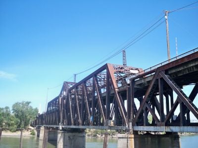
I Street Bridge, Historic railway and road bridge in Sacramento, United States

The I Street Bridge spans the Sacramento River with two distinct levels, accommodating railroad tracks on the lower deck and vehicle lanes on the upper level. The structure is a metal truss design featuring a rotating central span that can swing horizontally to permit water traffic passage.

The American Bridge Company completed this metal swing bridge in 1912, connecting Sacramento with Yolo County. Its completion marked a turning point for regional connectivity and supported the commercial growth of the era.

The bridge demonstrates early twentieth-century engineering methods and reflects the rapid infrastructure development that occurred during California's growth period. It served as a vital transportation hub connecting people and goods between Sacramento and surrounding areas.

The upper deck offers adequate clearance with pedestrian walkways on both sides for foot traffic. The lower level experiences regular train operations throughout the day, so caution is advised when approaching those areas.

The structure features a rotating central mechanism that can pivot on its axis to allow river vessels to pass through. This innovative design choice kept the waterway open for commercial shipping while maintaining road and rail connections.

The community of curious travelers

AroundUs brings together thousands of curated places, local tips, and hidden gems, enriched daily by 60,000 contributors worldwide.

Start exploring
Location
GPS coordinates
38.58624,-121.50625
Latest update
December 8, 2025 19:52
Around this place
Old Sacramento Waterfront
United States of America

Old Sacramento Waterfront

394 m
Crocker Art Museum
United States of America

Crocker Art Museum

1 km
California State Railroad Museum
United States of America

California State Railroad Museum

261 m
Tower Bridge
United States of America

Tower Bridge

659 m
Delta King
United States of America

Delta King

390 m
Ruhstaller Building
United States of America

Ruhstaller Building

1.2 km
United States of America

Weinstock's

673 m
Wells Fargo Center
United States of America

Wells Fargo Center

918 m
California State Military Museum
United States of America

California State Military Museum

557 m
U.S. Bank Tower
United States of America

U.S. Bank Tower

1.1 km
Pony Express Terminal
United States of America

Pony Express Terminal

451 m
Renaissance Tower
United States of America

Renaissance Tower

1.1 km
Robert T. Matsui United States Courthouse
United States of America

Robert T. Matsui United States Courthouse

722 m
Big Four Building
United States of America

Big Four Building

462 m
Eagle Theatre
United States of America

Eagle Theatre

303 m
Sacramento History Museum
United States of America

Sacramento History Museum

189 m
Bank of the West Tower
United States of America

Bank of the West Tower

1 km
Federal Building
United States of America

Federal Building

1.2 km
Cesar E. Chavez Plaza
United States of America

Cesar E. Chavez Plaza

1.2 km
Sacramento City Library
United States of America

Sacramento City Library

1.1 km
Jesse M. Unruh State Office Building
United States of America

Jesse M. Unruh State Office Building

1.2 km
Park Tower
United States of America

Park Tower

1.1 km
Towers on Capitol Mall
United States of America

Towers on Capitol Mall

740 m
Mesick House
United States of America

Mesick House

1.1 km
United States of America

Saint Andrews African Methodist Episcopal Church

918 m
Old Sacramento Historic District
United States of America

Old Sacramento Historic District

267 m
William Coleman Memorial Fountain
United States of America

William Coleman Memorial Fountain

1.2 km
Alkali Flat West Historic District
United States of America

Alkali Flat West Historic District

1.1 km
Show the full map
Reviews
Share your experience

No review yet

Discussions
Start a discussion...

No discussion yet

« I Street Bridge - Historic railway and road bridge in Sacramento, United States » is provided by Around Us (aroundus.com). Images and texts are derived from Wikimedia project under a Creative Commons license. You are allowed to copy, distribute, and modify copies of this page, under the conditions set by the license, as long as this note is clearly visible.

Discover hidden gems everywhere you go!

From secret cafés to breathtaking viewpoints, skip the crowded tourist spots and find places that match your style. Our app makes it easy with voice search, smart filtering, route optimization, and insider tips from travelers worldwide. Download now for the complete mobile experience.

Around Us App Screenshot

A unique approach to discovering new places

Le Figaro

All the places worth exploring

France Info

A tailor-made excursion in just a few clicks

20 Minutes

Around Us
Travel Guide & Maps
Download

Send to your phone

QR Code
1

Open the camera app on your mobile.

2

Point at the QR code with your camera. A notification will appear.

3

Tap the notification to open the link.