Enable Location

We need your location to show you interesting places around you

Discover nearby places

Find interesting locations and hidden gems around you

Precise directions

Get accurate directions and distances to places

Your location is never shared with other users. It's only used when you tap the location button.

Jibboom Street Bridge

Log in to your account

Start exploring — it's free

Trusted by 63,023 travelers worldwide

Continue with Google
Continue with Apple
or

We will send you a code to connect

By continuing, you accept our Terms and Conditions and our Privacy Policy

Check your inbox

We've sent a pincode in your inbox. Please enter the code below.

Jibboom Street Bridge
Discussion Reviews 1 Photos
1.9k Popularity

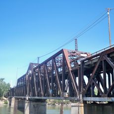
Jibboom Street Bridge, Road and swing bridge over American River in Sacramento, United States.

The Jibboom Street Bridge is a road bridge spanning the American River in Sacramento, measuring about 290 meters long overall. The structure features a central movable span section and two steel truss approach ramps on either side.

The bridge was built in 1931 and originally featured a movable center span that came from an earlier crossing between Oakland and Alameda. The opening mechanism was removed in 1958 when river shipping traffic stopped.

The bridge stands as an example of early 20th-century engineering, demonstrating the metal rivet-connected Pratt through truss design common in that period.

The bridge sits near Discovery Park and currently handles light vehicular traffic. It serves as a place to explore early industrial engineering and view the river landscape.

The structure once held the title of California's longest swing span and was a significant technical achievement of its era. Today it stands still, showing how transportation and shipping needs shifted across the decades.

The community of curious travelers

AroundUs brings together thousands of curated places, local tips, and hidden gems, enriched daily by 60,000 contributors worldwide.

Start exploring
Location
GPS coordinates
38.59971,-121.50620
Latest update
December 14, 2025 11:24
Around this place
Old Sacramento Waterfront
United States of America

Old Sacramento Waterfront

1.9 km
California State Railroad Museum
United States of America

California State Railroad Museum

1.7 km
The Ziggurat
United States of America

The Ziggurat

1.9 km
Tower Bridge
United States of America

Tower Bridge

2.1 km
I Street Bridge
United States of America

I Street Bridge

1.5 km
Delta King
United States of America

Delta King

1.9 km
United States of America

Weinstock's

2.1 km
California State Military Museum
United States of America

California State Military Museum

2 km
Pony Express Terminal
United States of America

Pony Express Terminal

1.9 km
Robert T. Matsui United States Courthouse
United States of America

Robert T. Matsui United States Courthouse

1.9 km
Big Four Building
United States of America

Big Four Building

1.9 km
Eagle Theatre
United States of America

Eagle Theatre

1.8 km
Sacramento History Museum
United States of America

Sacramento History Museum

1.7 km
Discovery Park
United States of America

Discovery Park

714 m
Federal Building
United States of America

Federal Building

2.2 km
Cesar E. Chavez Plaza
United States of America

Cesar E. Chavez Plaza

2.3 km
Sacramento City Library
United States of America

Sacramento City Library

2.2 km
Park Tower
United States of America

Park Tower

2.3 km
Towers on Capitol Mall
United States of America

Towers on Capitol Mall

2.2 km
J. Neely Johnson House
United States of America

J. Neely Johnson House

2.2 km
Mesick House
United States of America

Mesick House

1.9 km
United States of America

Saint Andrews African Methodist Episcopal Church

1.9 km
Old Sacramento Historic District
United States of America

Old Sacramento Historic District

1.7 km
William Coleman Memorial Fountain
United States of America

William Coleman Memorial Fountain

2.3 km
CalSTRS Building
United States of America

CalSTRS Building

1.7 km
Alkali Flat Central Historic District
United States of America

Alkali Flat Central Historic District

2.1 km
Alkali Flat North Historic District
United States of America

Alkali Flat North Historic District

2.1 km
Alkali Flat West Historic District
United States of America

Alkali Flat West Historic District

1.8 km
Show the full map
Reviews
Share your experience

No review yet

Discussions
Start a discussion...

No discussion yet

« Jibboom Street Bridge - Road and swing bridge over American River in Sacramento, United States » is provided by Around Us (aroundus.com). Images and texts are derived from Wikimedia project under a Creative Commons license. You are allowed to copy, distribute, and modify copies of this page, under the conditions set by the license, as long as this note is clearly visible.

Discover hidden gems everywhere you go!

From secret cafés to breathtaking viewpoints, skip the crowded tourist spots and find places that match your style. Our app makes it easy with voice search, smart filtering, route optimization, and insider tips from travelers worldwide. Download now for the complete mobile experience.

Around Us App Screenshot

A unique approach to discovering new places

Le Figaro

All the places worth exploring

France Info

A tailor-made excursion in just a few clicks

20 Minutes

Around Us
Travel Guide & Maps
Download

Send to your phone

QR Code
1

Open the camera app on your mobile.

2

Point at the QR code with your camera. A notification will appear.

3

Tap the notification to open the link.