Chest opened
+${chestReward.xp} XP
Explorer
NOUVEAU ×${chestReward.collectible.quantity}
tapez pour fermer
Chest locked

Open chests in the app

Around Us is built for your phone — chests unlock when you walk, explore and capture nearby places.

Enable Location

We need your location to show you interesting places around you

Discover nearby places

Find interesting locations and hidden gems around you

Precise directions

Get accurate directions and distances to places

Your location is never shared with other users. It's only used when you tap the location button.

Log in to your account

Start exploring — it's free

Trusted by 72,992 travelers worldwide

Continue with Google
Continue with Apple
or

We will send you a code to connect

By continuing, you accept our Terms and Conditions and our Privacy Policy

Check your inbox

We've sent a pincode in your inbox. Please enter the code below.

Clear Lake Volcanic Field
Discussion Reviews Photo
6.7k Popularity

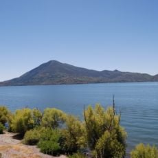
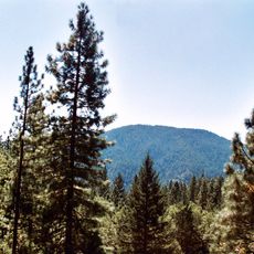
Clear Lake Volcanic Field, Volcanic field in Northern California, United States.

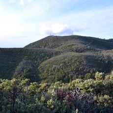
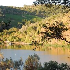
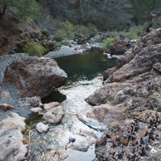
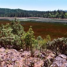
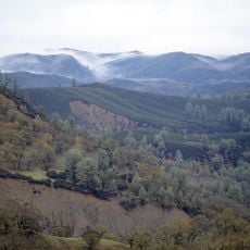
The Clear Lake Volcanic Field is a volcanic landscape in Northern California featuring numerous lava domes, cinder cones, and craters around Mount Konocti. The area displays active geothermal features including hot springs and steam vents that emerge from the underground heat system beneath the land.

The volcanic field formed approximately 2 million years ago with its most recent known eruption occurring around 11,000 years ago. This volcanic activity shaped the basin structure of Clear Lake and the surrounding terrain.

The Pomo people established settlements around Clear Lake Volcanic Field, utilizing its natural resources and incorporating the landscape into their traditions.

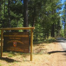
Access to the area is possible via hiking trails on Mount Konocti and various nature paths that are open year-round. Visitors should wear comfortable shoes and be prepared for uneven volcanic terrain.

The magma chamber beneath the volcanic field powers The Geysers, one of the world's largest facilities for harnessing geothermal energy. This underground heat source provides power to millions of people across the region.

The community of curious travelers

AroundUs brings together thousands of curated places, local tips, and hidden gems, enriched daily by 60,000 contributors worldwide.

Start exploring
Location
GPS coordinates
38.97000,-122.77000
Latest update
December 10, 2025 15:50
Around this place
City of Ten Thousand Buddhas
United States of America

City of Ten Thousand Buddhas

38.6 km
Mount Konocti
United States of America

Mount Konocti

557 m
Berryessa Snow Mountain National Monument
United States of America

Berryessa Snow Mountain National Monument

23.3 km
United States of America

Blue Lakes

31.1 km
Frog Woman Rock
United States of America

Frog Woman Rock

25.6 km
Cobb Mountain
United States of America

Cobb Mountain

18.3 km
Robert Louis Stevenson State Park
United States of America

Robert Louis Stevenson State Park

38.1 km
Clear Lake State Park
United States of America

Clear Lake State Park

5.6 km
Anderson Marsh State Historic Park
United States of America

Anderson Marsh State Historic Park

12.3 km
Boggs Mountain Demonstration State Forest
United States of America

Boggs Mountain Demonstration State Forest

18.1 km
Simi Winery
United States of America

Simi Winery

37.3 km
Crabtree Hot Springs, California
United States of America

Crabtree Hot Springs, California

35.9 km
Boggs Lake Ecological Reserve
United States of America

Boggs Lake Ecological Reserve

9.3 km
Blue Ridge Berryessa Natural Area
United States of America

Blue Ridge Berryessa Natural Area

40.4 km
Loch Lomond Vernal Pool Ecological Reserve
United States of America

Loch Lomond Vernal Pool Ecological Reserve

12.4 km
Cache Creek Wilderness
United States of America

Cache Creek Wilderness

23.6 km
Rice Fork
United States of America

Rice Fork

35.9 km
Francis Ford Coppola Winery
United States of America

Francis Ford Coppola Winery

33.9 km
Fetzer-Bonterra vineyards
United States of America

Fetzer-Bonterra vineyards

29.9 km
Lakeport Carnegie Library
United States of America

Lakeport Carnegie Library

14.9 km
California Coast Ranges Biosphere Reserve
United States of America

California Coast Ranges Biosphere Reserve

23 km
Old Lake County Courthouse
United States of America

Old Lake County Courthouse

15.1 km
Ferrari-Carano vineyards and winery
United States of America

Ferrari-Carano vineyards and winery

40.1 km
Reeve Wines
United States of America

Reeve Wines

35.2 km
Lambert Bridge
United States of America

Lambert Bridge

37.8 km
Gould-Shaw House
United States of America

Gould-Shaw House

28.1 km
Warm Springs Creek Bridge
United States of America

Warm Springs Creek Bridge

35.5 km
Lake Sonoma
United States of America

Lake Sonoma

36.2 km
Show the full map
Reviews
Share your experience

No review yet

Discussions
Start a discussion...

No discussion yet

« Clear Lake Volcanic Field - Volcanic field in Northern California, United States » is provided by Around Us (aroundus.com). Images and texts are derived from Wikimedia project under a Creative Commons license. You are allowed to copy, distribute, and modify copies of this page, under the conditions set by the license, as long as this note is clearly visible.

Discover hidden gems everywhere you go!

From secret cafés to breathtaking viewpoints, skip the crowded tourist spots and find places that match your style. Our app makes it easy with voice search, smart filtering, route optimization, and insider tips from travelers worldwide. Download now for the complete mobile experience.

Around Us App Screenshot

A unique approach to discovering new places

Le Figaro

All the places worth exploring

France Info

A tailor-made excursion in just a few clicks

20 Minutes

Around Us
Travel Guide & Maps
Download

Send to your phone

QR Code
1

Open the camera app on your mobile.

2

Point at the QR code with your camera. A notification will appear.

3

Tap the notification to open the link.