Chest opened
+${chestReward.xp} XP
Explorer
NOUVEAU ×${chestReward.collectible.quantity}
tapez pour fermer
Chest locked

Open chests in the app

Around Us is built for your phone — chests unlock when you walk, explore and capture nearby places.

Enable Location

We need your location to show you interesting places around you

Discover nearby places

Find interesting locations and hidden gems around you

Precise directions

Get accurate directions and distances to places

Your location is never shared with other users. It's only used when you tap the location button.

Yuba River

Log in to your account

Start exploring — it's free

Trusted by 72,877 travelers worldwide

Continue with Google
Continue with Apple
or

We will send you a code to connect

By continuing, you accept our Terms and Conditions and our Privacy Policy

Check your inbox

We've sent a pincode in your inbox. Please enter the code below.

Yuba River
Discussion Reviews 1 Photos
20.9k Popularity

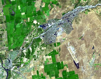
Yuba River, Mountain river in Sierra Nevada, California.

The Yuba River is a mountain stream in the Sierra Nevada that winds through deep rocky canyons filled with granite formations. It branches into three main forks that drain separate regions of the high country.

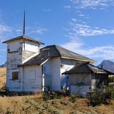
During the California Gold Rush in the 1800s, the river became one of the most important gold-bearing streams in the state. Large numbers of miners worked its banks and channels in search of wealth.

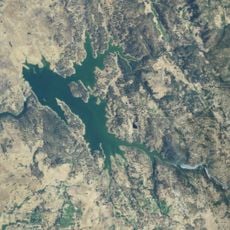
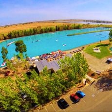
The river serves as a gathering place where visitors come to swim, picnic, and enjoy the outdoors with family and friends. Local communities have long relied on it as a place to connect with nature and each other.

Summer months from June through September offer the best water conditions for swimming and outdoor activities. The river has several easy-to-reach access points where visitors can start their exploration.

The mining operations of over 150 years ago left behind a transformed landscape of large gravel ridges and water basins along the riverbed. These altered landforms are now a striking part of the terrain visitors see today.

The community of curious travelers

AroundUs brings together thousands of curated places, local tips, and hidden gems, enriched daily by 60,000 contributors worldwide.

Start exploring
Location
GPS coordinates
39.12750,-121.59700
Latest update
December 7, 2025 10:05
Around this place
Sutter Buttes
United States of America

Sutter Buttes

21.5 km
South Yuba River State Park
United States of America

South Yuba River State Park

39.2 km
Bridgeport Covered Bridge
United States of America

Bridgeport Covered Bridge

39.3 km
Bok Kai Temple
United States of America

Bok Kai Temple

1.2 km
Englebright Lake
United States of America

Englebright Lake

30.9 km
Camp Far West Reservoir
United States of America

Camp Far West Reservoir

25.8 km
Colusa National Wildlife Refuge
United States of America

Colusa National Wildlife Refuge

38.7 km
Sutter National Wildlife Refuge
United States of America

Sutter National Wildlife Refuge

14.6 km
Ellis Lake
United States of America

Ellis Lake

2.4 km
Fremont Weir Wildlife Area
United States of America

Fremont Weir Wildlife Area

42.3 km
Oroville Chinese Temple
United States of America

Oroville Chinese Temple

43.1 km
North Star House
United States of America

North Star House

45.5 km
Englebright Dam
United States of America

Englebright Dam

30.9 km
Community Memorial Museum of Sutter County
United States of America

Community Memorial Museum of Sutter County

4 km
Live Oak Historic Commercial District
United States of America

Live Oak Historic Commercial District

17.3 km
Yuba City Astronomical Observatory
United States of America

Yuba City Astronomical Observatory

3.5 km
Grand Island Shrine
United States of America

Grand Island Shrine

29.3 km
Hart Building
United States of America

Hart Building

1.5 km
Wake Island Water Park
United States of America

Wake Island Water Park

42.7 km
Collins Lake Beach
United States of America

Collins Lake Beach

33 km
Packard Library
United States of America

Packard Library

1.6 km
Colusa County Courthouse
United States of America

Colusa County Courthouse

36.8 km
Wheatland Masonic Temple
United States of America

Wheatland Masonic Temple

19.9 km
Marysville Historic Commercial District
United States of America

Marysville Historic Commercial District

1.4 km
Oroville Carnegie Library
United States of America

Oroville Carnegie Library

43 km
West Butte Schoolhouse
United States of America

West Butte Schoolhouse

25.2 km
Oroville Chinese Temple
United States of America

Oroville Chinese Temple

43.1 km
Oroville State Theatre
United States of America

Oroville State Theatre

43 km
Show the full map
Reviews
Share your experience

No review yet

Discussions
Start a discussion...

No discussion yet

« Yuba River - Mountain river in Sierra Nevada, California » is provided by Around Us (aroundus.com). Images and texts are derived from Wikimedia project under a Creative Commons license. You are allowed to copy, distribute, and modify copies of this page, under the conditions set by the license, as long as this note is clearly visible.

Discover hidden gems everywhere you go!

From secret cafés to breathtaking viewpoints, skip the crowded tourist spots and find places that match your style. Our app makes it easy with voice search, smart filtering, route optimization, and insider tips from travelers worldwide. Download now for the complete mobile experience.

Around Us App Screenshot

A unique approach to discovering new places

Le Figaro

All the places worth exploring

France Info

A tailor-made excursion in just a few clicks

20 Minutes

Around Us
Travel Guide & Maps
Download

Send to your phone

QR Code
1

Open the camera app on your mobile.

2

Point at the QR code with your camera. A notification will appear.

3

Tap the notification to open the link.