Chest opened
+${chestReward.xp} XP
Explorer
NOUVEAU ×${chestReward.collectible.quantity}
tapez pour fermer
Chest locked

Open chests in the app

Around Us is built for your phone — chests unlock when you walk, explore and capture nearby places.

Enable Location

We need your location to show you interesting places around you

Discover nearby places

Find interesting locations and hidden gems around you

Precise directions

Get accurate directions and distances to places

Your location is never shared with other users. It's only used when you tap the location button.

Beale Air Force Base

Log in to your account

Start exploring — it's free

Trusted by 72,879 travelers worldwide

Continue with Google
Continue with Apple
or

We will send you a code to connect

By continuing, you accept our Terms and Conditions and our Privacy Policy

Check your inbox

We've sent a pincode in your inbox. Please enter the code below.

Discussion Reviews 3 Photos
88.2k Popularity

Beale Air Force Base, Military air base in Yuba County, California, United States.

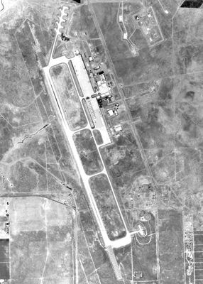
Beale Air Force Base is a military airfield in Yuba County in northern California, roughly 40 miles (64 kilometers) north of Sacramento. The installation covers an area of about 36 square miles (93 square kilometers) between the cities of Marysville and Yuba City.

The facility was established in 1942 as Camp Beale and initially served as a training ground for infantry troops during the Second World War. After a brief closure in the postwar years, it reopened in 1951 as an air force installation and received its current status.

The name honors Edward Fitzgerald Beale, a nineteenth-century California pioneer who served as surveyor and diplomat. Within the grounds, preserved foundations and building remnants recall the period when soldiers trained here for deployment in the Second World War.

Access to the installation is through several entrance gates, each with set operating hours and requiring valid identification. Visitors should allow enough time for security checks and inquire in advance about current access requirements.

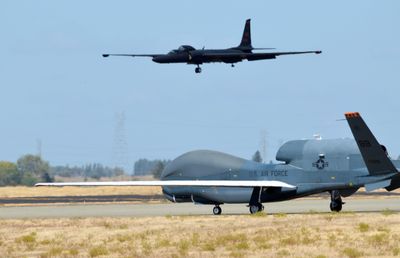
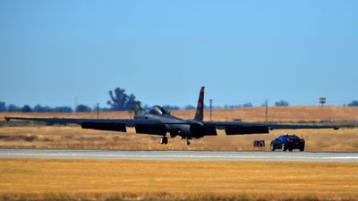
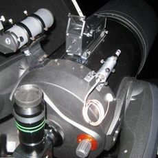
The grounds host a large radar installation for monitoring space, part of a nationwide early warning system. Additionally, one of the few squadrons operating reconnaissance aircraft for high-altitude missions is stationed here.

The community of curious travelers

AroundUs brings together thousands of curated places, local tips, and hidden gems, enriched daily by 60,000 contributors worldwide.

Start exploring
Location
Inception
1942
Official opening
1942
GPS coordinates
39.13611,-121.43639
Latest update
December 13, 2025 15:55
Around this place
Sutter Buttes
United States of America

Sutter Buttes

33.8 km
Empire Mine State Historic Park
United States of America

Empire Mine State Historic Park

34.8 km
New Bullards Bar Reservoir
United States of America

New Bullards Bar Reservoir

38.3 km
New Bullards Bar Dam
United States of America

New Bullards Bar Dam

38.2 km
South Yuba River State Park
United States of America

South Yuba River State Park

27.2 km
Bridgeport Covered Bridge
United States of America

Bridgeport Covered Bridge

27.2 km
Bok Kai Temple
United States of America

Bok Kai Temple

13 km
Englebright Lake
United States of America

Englebright Lake

18.4 km
Home of Lola Montez
United States of America

Home of Lola Montez

33.4 km
Camp Far West Reservoir
United States of America

Camp Far West Reservoir

14.1 km
Sutter National Wildlife Refuge
United States of America

Sutter National Wildlife Refuge

28.2 km
Ellis Lake
United States of America

Ellis Lake

13.1 km
North Star House
United States of America

North Star House

31.7 km
Englebright Dam
United States of America

Englebright Dam

18.5 km
Mount Saint Mary's Convent and Academy
United States of America

Mount Saint Mary's Convent and Academy

33.1 km
Grass Valley Public Library
United States of America

Grass Valley Public Library

33.4 km
Community Memorial Museum of Sutter County
United States of America

Community Memorial Museum of Sutter County

17.3 km
Live Oak Historic Commercial District
United States of America

Live Oak Historic Commercial District

24.8 km
Yuba City Astronomical Observatory
United States of America

Yuba City Astronomical Observatory

17.2 km
Hart Building
United States of America

Hart Building

13.1 km
Collins Lake Beach
United States of America

Collins Lake Beach

24.1 km
Packard Library
United States of America

Packard Library

13.1 km
Wheatland Masonic Temple
United States of America

Wheatland Masonic Temple

14 km
Aaron A. Sargent House
United States of America

Aaron A. Sargent House

38.6 km
Marysville Historic Commercial District
United States of America

Marysville Historic Commercial District

13.1 km
Hoyt Crossing Nude Beach
United States of America

Hoyt Crossing Nude Beach

35.9 km
Northstar Mining Museum
United States of America

Northstar Mining Museum

32.6 km
Grass Valley Library-Royce Branch
United States of America

Grass Valley Library-Royce Branch

33.4 km
Show the full map
Reviews
Share your experience

No review yet

Discussions
Start a discussion...

No discussion yet

« Beale Air Force Base - Military air base in Yuba County, California, United States » is provided by Around Us (aroundus.com). Images and texts are derived from Wikimedia project under a Creative Commons license. You are allowed to copy, distribute, and modify copies of this page, under the conditions set by the license, as long as this note is clearly visible.

Discover hidden gems everywhere you go!

From secret cafés to breathtaking viewpoints, skip the crowded tourist spots and find places that match your style. Our app makes it easy with voice search, smart filtering, route optimization, and insider tips from travelers worldwide. Download now for the complete mobile experience.

Around Us App Screenshot

A unique approach to discovering new places

Le Figaro

All the places worth exploring

France Info

A tailor-made excursion in just a few clicks

20 Minutes

Around Us
Travel Guide & Maps
Download

Send to your phone

QR Code
1

Open the camera app on your mobile.

2

Point at the QR code with your camera. A notification will appear.

3

Tap the notification to open the link.