Chest opened
+${chestReward.xp} XP
Explorer
NOUVEAU ×${chestReward.collectible.quantity}
tapez pour fermer
Chest locked

Open chests in the app

Around Us is built for your phone — chests unlock when you walk, explore and capture nearby places.

Enable Location

We need your location to show you interesting places around you

Discover nearby places

Find interesting locations and hidden gems around you

Precise directions

Get accurate directions and distances to places

Your location is never shared with other users. It's only used when you tap the location button.

Zuni-Bandera volcanic field

Log in to your account

Start exploring — it's free

Trusted by 73,047 travelers worldwide

Continue with Google
Continue with Apple
or

We will send you a code to connect

By continuing, you accept our Terms and Conditions and our Privacy Policy

Check your inbox

We've sent a pincode in your inbox. Please enter the code below.

Zuni-Bandera volcanic field
Discussion Reviews 1 Photos
5.2k Popularity

Zuni-Bandera volcanic field, Volcanic field in New Mexico, United States

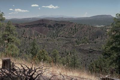
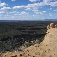
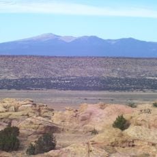
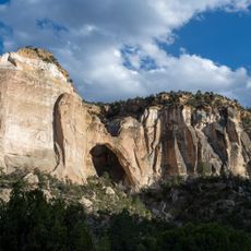
The Zuni-Bandera volcanic field is a large volcanic landscape in west-central New Mexico containing over 100 volcanic vents and extensive lava flows. The black lava rock forms a dramatic terrain with caves and cinder cones of varying sizes.

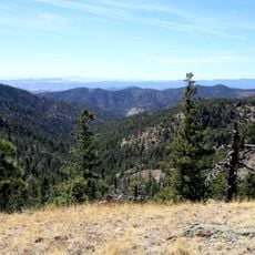
The volcanic field developed over millions of years, with its most recent eruption creating a massive lava sheet that spread far northward. This ancient lava formation, created more than 800 years ago, still shapes the landscape today.

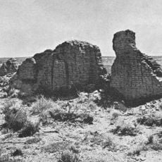
The Zuni and Pueblo peoples used the lava flows as natural pathways between their settlements, with the black rock formations serving as important landmarks across the landscape.

The area is accessible from Grants, where you can find hiking trails to explore the black lava formations and caves. Early morning or late afternoon visits work best to avoid the intense midday heat.

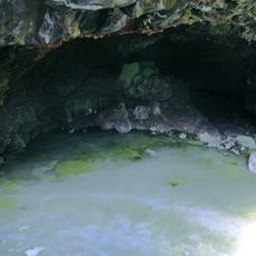
An ice cave within the field remains below freezing year-round, allowing ice formations to persist throughout the seasons. The ice displays a greenish tint from algae that grows on the frozen surfaces.

The community of curious travelers

AroundUs brings together thousands of curated places, local tips, and hidden gems, enriched daily by 60,000 contributors worldwide.

Start exploring
Location
Elevation above the sea
2,550 m
GPS coordinates
34.80000,-108.00000
Latest update
December 10, 2025 16:27
Around this place
Karl G. Jansky Very Large Array
United States of America

Karl G. Jansky Very Large Array

87.6 km
United States of America

Los Lunas Decalogue Stone

91.8 km
Mount Taylor
United States of America

Mount Taylor

60.5 km
The Lightning Field
United States of America

The Lightning Field

33 km
Very Long Baseline Array
United States of America

Very Long Baseline Array

87.6 km
Fort Wingate
United States of America

Fort Wingate

89.1 km
Hawikuh Ruins
United States of America

Hawikuh Ruins

91.2 km
Bandera Volcano Ice Cave
United States of America

Bandera Volcano Ice Cave

22.6 km
Bluewater Lake State Park
United States of America

Bluewater Lake State Park

55.9 km
United States of America

Enchanted Mesa

43.1 km
El Malpais National Conservation Area
United States of America

El Malpais National Conservation Area

6.8 km
San Estevan Del Rey Mission Church
United States of America

San Estevan Del Rey Mission Church

39.6 km
United States of America

Dowa Yalanne

77.6 km
Ladron Peak
United States of America

Ladron Peak

93.2 km
Cebolla Wilderness
United States of America

Cebolla Wilderness

9.2 km
Acoma Curio Shop
United States of America

Acoma Curio Shop

48.5 km
Datil-Mogollon Section
United States of America

Datil-Mogollon Section

52.3 km
Rio Puerco Bridge
United States of America

Rio Puerco Bridge

100 km
Grant meteorite
United States of America

Grant meteorite

41.8 km
Kin Ya-ah
United States of America

Kin Ya-ah

98.1 km
San Jose de la Laguna Mission and Convento
United States of America

San Jose de la Laguna Mission and Convento

61.6 km
Bowlin's Old Crater Trading Post
United States of America

Bowlin's Old Crater Trading Post

53.9 km
Grants-Milan Flight Service Station
United States of America

Grants-Milan Flight Service Station

41.8 km
Roy T. Herman's Garage and Service Station
United States of America

Roy T. Herman's Garage and Service Station

69.5 km
Charley's Automotive Service
United States of America

Charley's Automotive Service

41.5 km
La Ventana Natural Arch
United States of America

La Ventana Natural Arch

12.8 km
Gallo Mountains
United States of America

Gallo Mountains

98 km
Shiva:Shiwana
United States of America

Shiva:Shiwana

87.9 km
Show the full map
Reviews
Share your experience

No review yet

Discussions
Start a discussion...

No discussion yet

« Zuni-Bandera volcanic field - Volcanic field in New Mexico, United States » is provided by Around Us (aroundus.com). Images and texts are derived from Wikimedia project under a Creative Commons license. You are allowed to copy, distribute, and modify copies of this page, under the conditions set by the license, as long as this note is clearly visible.

Discover hidden gems everywhere you go!

From secret cafés to breathtaking viewpoints, skip the crowded tourist spots and find places that match your style. Our app makes it easy with voice search, smart filtering, route optimization, and insider tips from travelers worldwide. Download now for the complete mobile experience.

Around Us App Screenshot

A unique approach to discovering new places

Le Figaro

All the places worth exploring

France Info

A tailor-made excursion in just a few clicks

20 Minutes

Around Us
Travel Guide & Maps
Download

Send to your phone

QR Code
1

Open the camera app on your mobile.

2

Point at the QR code with your camera. A notification will appear.

3

Tap the notification to open the link.