Enable Location

We need your location to show you interesting places around you

Discover nearby places

Find interesting locations and hidden gems around you

Precise directions

Get accurate directions and distances to places

Your location is never shared with other users. It's only used when you tap the location button.

Log in to your account

Start exploring — it's free

Trusted by 62,248 travelers worldwide

Continue with Google
Continue with Apple
or

We will send you a code to connect

By continuing, you accept our Terms and Conditions and our Privacy Policy

Check your inbox

We've sent a pincode in your inbox. Please enter the code below.

El Vado Lake

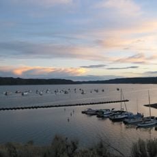
El Vado Lake, body of water

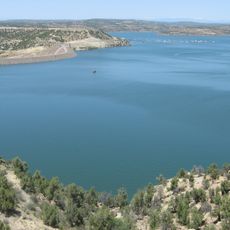
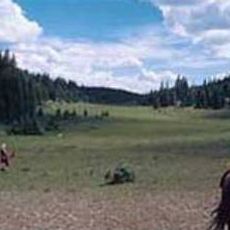
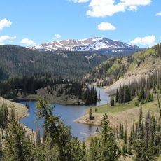
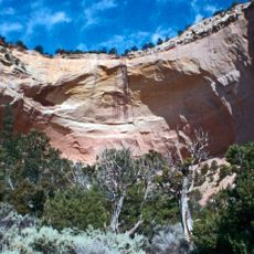
El Vado Lake is a large reservoir in the mountains of Rio Arriba County, located about 12 miles southwest of Tierra Amarilla. The water is surrounded by forested slopes and rocky hills, creating a valley setting where layers of different colored rocks visible along the shoreline reveal the ancient geological history of the region.

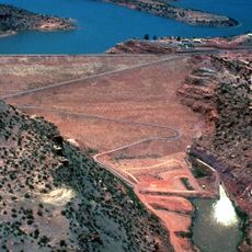
The reservoir was created in 1935 when a dam was built to store water for farming and to honor the water rights of local Native American communities. The dam was reinforced and improved in the 1950s and 1960s to hold larger water volumes when needed.

El Vado Lake takes its name from "the ford", referring to the natural river crossing that once served indigenous peoples traveling through the region. This historical crossing point shaped how people moved through the mountains and remains central to the place's identity.

The park is easy to reach via State Road 112 south of Tierra Amarilla, where signs guide you to camping areas, boat ramps, and picnic spots. Check current conditions before visiting, as water levels and weather can affect what activities are available.

Before the dam was built, a bustling town called El Vado occupied this location, where loggers worked in large sawmills cutting and moving timber. The old town is now completely submerged, with its streets and buildings now part of the lake floor.

The community of curious travelers

AroundUs brings together thousands of curated places, local tips, and hidden gems, enriched daily by 60,000 contributors worldwide.

Start exploring
GPS coordinates
36.60500,-106.74800
Latest update
February 7, 2026 11:00
Around this place
Ghost Ranch
United States of America

Ghost Ranch

39.2 km
Cumbres and Toltec Scenic Railroad
United States of America

Cumbres and Toltec Scenic Railroad

36 km
Navajo Lake
United States of America

Navajo Lake

79.6 km
Georgia O'Keeffe Home and Studio
United States of America

Georgia O'Keeffe Home and Studio

58.7 km
Monastery of Christ in the Desert
United States of America

Monastery of Christ in the Desert

26 km
Cerro Pedernal
United States of America

Cerro Pedernal

53.8 km
Pagosa hot springs
United States of America

Pagosa hot springs

77.8 km
Cumbres Pass
United States of America

Cumbres Pass

53.3 km
Navajo State Park
United States of America

Navajo State Park

74.1 km
Ojo Caliente Mineral Springs Resort & Spa
United States of America

Ojo Caliente Mineral Springs Resort & Spa

70.8 km
Chicoma Mountain
United States of America

Chicoma Mountain

74.1 km
San Antonio Mountain
United States of America

San Antonio Mountain

71 km
Fenton Lake State Park
United States of America

Fenton Lake State Park

80.5 km
D&RGW 463
United States of America

D&RGW 463

36.5 km
San Pedro Parks Wilderness
United States of America

San Pedro Parks Wilderness

57.2 km
Abiquiu Dam
United States of America

Abiquiu Dam

50 km
Conejos Peak
United States of America

Conejos Peak

77.7 km
Ojo Caliente Hot Springs Round Barn
United States of America

Ojo Caliente Hot Springs Round Barn

70.8 km
Crow Canyon Archaeological District
United States of America

Crow Canyon Archaeological District

77.9 km
Posi-ouinge
United States of America

Posi-ouinge

70.7 km
Frances Canyon Ruin
United States of America

Frances Canyon Ruin

69.3 km
Tsama Pueblo
United States of America

Tsama Pueblo

66 km
Labo Del Rio Bridge
United States of America

Labo Del Rio Bridge

78.6 km
Fort Lowell
United States of America

Fort Lowell

21.6 km
Samuel Sanchez House
United States of America

Samuel Sanchez House

24.6 km
Gilbert Martinez Barn
United States of America

Gilbert Martinez Barn

19.9 km
Sanchez-March House
United States of America

Sanchez-March House

21.9 km
Echo amphitheatre
United States of America

Echo amphitheatre

33.7 km
Show the full map
« El Vado Lake - body of water » is provided by Around Us (aroundus.com). Images and texts are derived from Wikimedia project under a Creative Commons license. You are allowed to copy, distribute, and modify copies of this page, under the conditions set by the license, as long as this note is clearly visible.

Discover hidden gems everywhere you go!

From secret cafés to breathtaking viewpoints, skip the crowded tourist spots and find places that match your style. Our app makes it easy with voice search, smart filtering, route optimization, and insider tips from travelers worldwide. Download now for the complete mobile experience.

Around Us App Screenshot

A unique approach to discovering new places

Le Figaro

All the places worth exploring

France Info

A tailor-made excursion in just a few clicks

20 Minutes

Around Us
Travel Guide & Maps
Download

Send to your phone

QR Code
1

Open the camera app on your mobile.

2

Point at the QR code with your camera. A notification will appear.

3

Tap the notification to open the link.