Baudette – Rainy River International Bridge
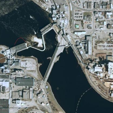
Baudette – Rainy River International Bridge, International bridge at Minnesota-Ontario border, United States and Canada
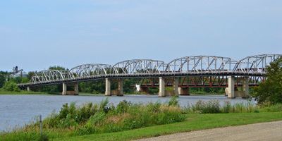
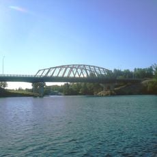
The Baudette-Rainy River International Bridge is a road and pedestrian crossing over the Rainy River connecting Minnesota and Ontario. The structure spans the water with multiple sections and provides dedicated lanes for vehicles alongside a separate walkway for people on foot.
Construction began in 1958 and the crossing opened in 1960, replacing the ferry service that had connected the communities until that time. This permanent link marked an important shift in how people and goods moved across the border.
The bridge serves as a daily crossing point for people living on both sides of the river who work, shop, or visit family across the border. It reflects how closely the communities depend on each other for commerce and social life.
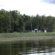
Border checkpoints operate continuously on both sides to process travelers and vehicles. Walking across is permitted, and you should have proper identification and documents ready before you approach the crossing.
The structure was built with six distinct spans to cross the river safely and accommodate river traffic below. This design reflects engineering choices made to work with the waterway rather than interrupt it.
Location: Baudette
Location: Rainy River
Official opening: 1960
Part of: Canada–United States border
GPS coordinates: 48.71917,-94.59028
Latest update: December 14, 2025 11:22
Fort Saint Charles
77 km
Fort Frances – International Falls International Bridge
88.3 km
Big Bog State Recreation Area
58.9 km
Grand Mound
68.7 kmNorthwest Angle State Forest
70.7 km
Zippel Bay State Park
25.5 km
Kay-Nah-Chi-Wah-Nung
38.8 km
Fort Saint Pierre
91.1 km
Agassiz National Wildlife Refuge
108.3 km
Hayes Lake State Park
68.3 km
Franz Jevne State Park
38.7 km
Agassiz Wilderness
104 km
Sioux Narrows Bridge
85.2 km
Birch Point Provincial Park
68.6 km
Finstad's Auto Marine Shop
92.1 km
Roseau County Courthouse
87.4 km
Koochiching County Courthouse
87.7 km
Gold Mine Sites
105.4 km
Sioux Narrows Provincial Park
87.8 km
Agassiz Headquarters Fire Observation Tower
112.9 km
Rainy Lake Visitor Center
106.2 km
Black Bay Lookout Tower
105 km
Faunce Lookout Tower
30.2 km
Rapid River Fire Tower
15.6 km
Northwest Angle Provincial Forest
84.9 km
Linder Fire Tower
66.6 km
Blackduck Lookout Tower
115 km
Prosper Lookout Tower
35.6 kmVisited this place? Tap the stars to rate it and share your experience / photos with the community! Try now! You can cancel it anytime.
Discover hidden gems everywhere you go!
From secret cafés to breathtaking viewpoints, skip the crowded tourist spots and find places that match your style. Our app makes it easy with voice search, smart filtering, route optimization, and insider tips from travelers worldwide. Download now for the complete mobile experience.
A unique approach to discovering new places❞
— Le Figaro
All the places worth exploring❞
— France Info
A tailor-made excursion in just a few clicks❞
— 20 Minutes