Chest opened
+${chestReward.xp} XP
Explorer
NOUVEAU ×${chestReward.collectible.quantity}
tapez pour fermer
Chest locked

Open chests in the app

Around Us is built for your phone — chests unlock when you walk, explore and capture nearby places.

Enable Location

We need your location to show you interesting places around you

Discover nearby places

Find interesting locations and hidden gems around you

Precise directions

Get accurate directions and distances to places

Your location is never shared with other users. It's only used when you tap the location button.

Doodhpathri

Log in to your account

Start exploring — it's free

Trusted by 72,888 travelers worldwide

Continue with Google
Continue with Apple
or

We will send you a code to connect

By continuing, you accept our Terms and Conditions and our Privacy Policy

Check your inbox

We've sent a pincode in your inbox. Please enter the code below.

Doodhpathri
Discussion Reviews 1 Photos
25.8k Popularity

Doodhpathri, Hill station in Budgam district, India

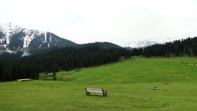
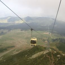
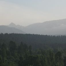
Doodhpathri is a hill station in the Pir Panjal Range situated at about 2,730 meters elevation, featuring rolling meadows interspersed with pine forests and clear streams that flow over rocky beds. The landscape combines open grassland with clusters of trees and flowing water, creating a layered terrain with natural clearings and forested sections.

A revered saint named Sheikh Noor din Noorani discovered water that appeared milk-like when he struck the ground with his stick in these meadows. This encounter became central to the place's identity and local heritage.

Local shepherds from the Budgam plains bring their herds to graze these meadows each summer, a practice that has continued for generations. The seasonal rhythm of shepherding shapes how the landscape is used and valued by the surrounding communities.

Two routes connect this place to Srinagar: a shorter 42-kilometer path via Budgam and Khansahib, or a longer 50-kilometer route along the Gulmarg road. The destination is accessible by vehicle, with the shorter route being more direct but steeper, while the longer option offers a more gradual climb.

The water running through the meadows stays extremely cold throughout the year and takes on a milky appearance when viewed from a distance. These two characteristics together create a distinctive visual and physical feature that defines the landscape's most memorable quality.

The community of curious travelers

AroundUs brings together thousands of curated places, local tips, and hidden gems, enriched daily by 60,000 contributors worldwide.

Start exploring
Location
Elevation above the sea
2,730 m
GPS coordinates
33.85750,74.56417
Latest update
December 20, 2025 16:03
Reviews
Share your experience

No review yet

Discussions
Start a discussion...

No discussion yet

« Doodhpathri - Hill station in Budgam district, India » is provided by Around Us (aroundus.com). Images and texts are derived from Wikimedia project under a Creative Commons license. You are allowed to copy, distribute, and modify copies of this page, under the conditions set by the license, as long as this note is clearly visible.

Discover hidden gems everywhere you go!

From secret cafés to breathtaking viewpoints, skip the crowded tourist spots and find places that match your style. Our app makes it easy with voice search, smart filtering, route optimization, and insider tips from travelers worldwide. Download now for the complete mobile experience.

Around Us App Screenshot

A unique approach to discovering new places

Le Figaro

All the places worth exploring

France Info

A tailor-made excursion in just a few clicks

20 Minutes

Around Us
Travel Guide & Maps
Download

Send to your phone

QR Code
1

Open the camera app on your mobile.

2

Point at the QR code with your camera. A notification will appear.

3

Tap the notification to open the link.