Chest opened
+${chestReward.xp} XP
Explorer
NOUVEAU ×${chestReward.collectible.quantity}
tapez pour fermer
Chest locked

Open chests in the app

Around Us is built for your phone — chests unlock when you walk, explore and capture nearby places.

Enable Location

We need your location to show you interesting places around you

Discover nearby places

Find interesting locations and hidden gems around you

Precise directions

Get accurate directions and distances to places

Your location is never shared with other users. It's only used when you tap the location button.

Republican River

Log in to your account

Start exploring — it's free

Trusted by 72,880 travelers worldwide

Continue with Google
Continue with Apple
or

We will send you a code to connect

By continuing, you accept our Terms and Conditions and our Privacy Policy

Check your inbox

We've sent a pincode in your inbox. Please enter the code below.

Republican River
Discussion Reviews 1 Photos
14.7k Popularity

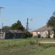
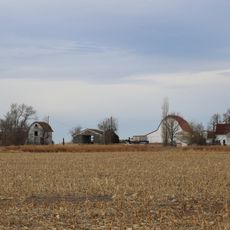
Republican River, Major river system in Nebraska and Kansas, United States.

The Republican River is a waterway that flows across roughly 450 kilometers from eastern Colorado through Nebraska and Kansas. It passes through numerous counties before joining the Smoky Hill River near Junction City, Kansas.

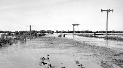
The river takes its name from a Pawnee Indian group that established settlements along its banks during the 1800s. A catastrophic flood in 1935 became one of Nebraska's worst flooding disasters, causing hundreds of deaths and extensive damage across the region.

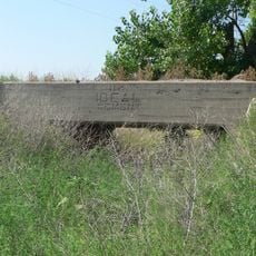
The Republican River Pegram Truss Bridge near Concordia stands as an engineering achievement listed in the National Register of Historic Places.

Several access points are scattered along the waterway where visitors can launch boats or fish from the banks. Plan your visit during warmer months when water conditions are typically more favorable for outdoor activities.

The 1935 flood along the Republican River ranks as Nebraska's most severe flood disaster, resulting in 113 casualties and widespread destruction.

The community of curious travelers

AroundUs brings together thousands of curated places, local tips, and hidden gems, enriched daily by 60,000 contributors worldwide.

Start exploring
Location
Location
Location
Location
Location
Location
Location
Location
Location
Location
Location
Location
GPS coordinates
40.01999,-101.93785
Latest update
December 7, 2025 20:20
Around this place
Elitch Gardens Carousel
United States of America

Elitch Gardens Carousel

84 km
Minor Sod House
United States of America

Minor Sod House

65.9 km
Mary Seaman Ennis House
United States of America

Mary Seaman Ennis House

77.4 km
Massacre Canyon Historical Monument
United States of America

Massacre Canyon Historical Monument

85.4 km
Champion Mill
United States of America

Champion Mill

52.6 km
Grant City Park
United States of America

Grant City Park

93.9 km
Howard T. Sawhill City Park
United States of America

Howard T. Sawhill City Park

29.8 km
St. Paul's Methodist Protestant Church
United States of America

St. Paul's Methodist Protestant Church

96.2 km
Farmers State Bank of Cope
United States of America

Farmers State Bank of Cope

87.6 km
Dundy County Courthouse
United States of America

Dundy County Courthouse

34.7 km
Texas Trail Stone Corral
United States of America

Texas Trail Stone Corral

69 km
Cliff Theater
United States of America

Cliff Theater

25 km
Goodland City Library
United States of America

Goodland City Library

77.4 km
Phillips County Courthouse
United States of America

Phillips County Courthouse

69.9 km
Ideal Cement bridge (Stratton, Nebraska)
United States of America

Ideal Cement bridge (Stratton, Nebraska)

65.3 km
Ruleton School
United States of America

Ruleton School

75.6 km
Shirley Opera House
United States of America

Shirley Opera House

80.2 km
W. E. Heginbotham House
United States of America

W. E. Heginbotham House

69.7 km
First National Bank of Haxtun
United States of America

First National Bank of Haxtun

90.7 km
Grant Commercial Historic District
United States of America

Grant Commercial Historic District

93.2 km
Kuhrt Ranch
United States of America

Kuhrt Ranch

64.3 km
Perkins County Courthouse
United States of America

Perkins County Courthouse

93.2 km
Henry Hickert Building
United States of America

Henry Hickert Building

45.8 km
Pinkie's Corner
United States of America

Pinkie's Corner

58.5 km
Cheyenne County Courthouse
United States of America

Cheyenne County Courthouse

29.8 km
Chase County Courthouse
United States of America

Chase County Courthouse

61.1 km
Millage Farm Rural Historic District
United States of America

Millage Farm Rural Historic District

67.3 km
Old Town Museum
United States of America

Old Town Museum

85.4 km
Show the full map
Reviews
Share your experience

No review yet

Discussions
Start a discussion...

No discussion yet

« Republican River - Major river system in Nebraska and Kansas, United States » is provided by Around Us (aroundus.com). Images and texts are derived from Wikimedia project under a Creative Commons license. You are allowed to copy, distribute, and modify copies of this page, under the conditions set by the license, as long as this note is clearly visible.

Discover hidden gems everywhere you go!

From secret cafés to breathtaking viewpoints, skip the crowded tourist spots and find places that match your style. Our app makes it easy with voice search, smart filtering, route optimization, and insider tips from travelers worldwide. Download now for the complete mobile experience.

Around Us App Screenshot

A unique approach to discovering new places

Le Figaro

All the places worth exploring

France Info

A tailor-made excursion in just a few clicks

20 Minutes

Around Us
Travel Guide & Maps
Download

Send to your phone

QR Code
1

Open the camera app on your mobile.

2

Point at the QR code with your camera. A notification will appear.

3

Tap the notification to open the link.