Enable Location

We need your location to show you interesting places around you

Discover nearby places

Find interesting locations and hidden gems around you

Precise directions

Get accurate directions and distances to places

Your location is never shared with other users. It's only used when you tap the location button.

Ouachita National Forest

Log in to your account

Start exploring — it's free

Trusted by 64,550 travelers worldwide

Continue with Google
Continue with Apple
or

We will send you a code to connect

By continuing, you accept our Terms and Conditions and our Privacy Policy

Check your inbox

We've sent a pincode in your inbox. Please enter the code below.

Discussion Reviews 1 Photos
26k Popularity

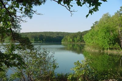
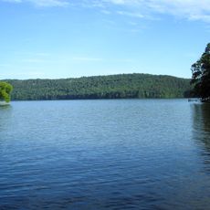
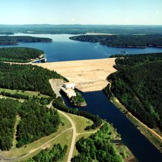
Ouachita National Forest, National forest in western Arkansas and eastern Oklahoma, United States.

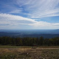
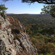
The Ouachita National Forest spreads across rolling mountains with dense woodlands, clear streams, and abundant wildlife across Arkansas and Oklahoma. The forest features varied landscapes with hillsides, valleys, and open clearings where different plant species thrive.

This forest reserve was established in 1907 to protect the woodlands across this region. Since then, forest management has shaped how the land looks and grows while adapting to different needs over the decades.

People have gathered in these woods for hunting, fishing, and collecting plants for food and medicine over many centuries. Local communities still visit family fishing spots and camping areas that hold deep meaning for them.

The forest has roads and marked trails that lead to campsites, hiking paths, and fishing areas throughout the region. Visitors should prepare for changing weather and bring proper gear, as conditions vary depending on the season and elevation.

The forest is home to rare creatures like certain earthworms found nowhere else in the world. These organisms highlight how this particular ecosystem has developed its own distinctive life forms.

The community of curious travelers

AroundUs brings together thousands of curated places, local tips, and hidden gems, enriched daily by 60,000 contributors worldwide.

Start exploring
Location
Operator
United States Forest Service
GPS coordinates
34.50000,-94.25000
Latest update
December 20, 2025 15:41
Around this place
Crater of Diamonds State Park
United States of America

Crater of Diamonds State Park

74.5 km
Hot Springs National Park
United States of America

Hot Springs National Park

109.8 km
Bathhouse Row
United States of America

Bathhouse Row

109.8 km
Broken Bow Lake
United States of America

Broken Bow Lake

53.8 km
Arlington Hotel
United States of America

Arlington Hotel

109.8 km
Lake Hamilton and Lake Catherine
United States of America

Lake Hamilton and Lake Catherine

106.8 km
Beavers Bend Resort Park
United States of America

Beavers Bend Resort Park

57.6 km
Garvan Woodland Gardens
United States of America

Garvan Woodland Gardens

110.6 km
DeGray Lake
United States of America

DeGray Lake

109.3 km
Hot Springs High School
United States of America

Hot Springs High School

109.8 km
Queen Wilhelmina State Park
United States of America

Queen Wilhelmina State Park

23.3 km
United States of America

Heavener Runestone

53.6 km
Historic Washington State Park
United States of America

Historic Washington State Park

96.2 km
United States of America

Winding Stair Mountain National Recreation Area

56.3 km
Magic Springs and Crystal Falls
United States of America

Magic Springs and Crystal Falls

113.1 km
United States of America

Millwood Lake

84.6 km
Bill Clinton Boyhood Home
United States of America

Bill Clinton Boyhood Home

110.5 km
Arkansas Alligator Farm and Petting Zoo
United States of America

Arkansas Alligator Farm and Petting Zoo

108 km
DeGray Lake Resort State Park
United States of America

DeGray Lake Resort State Park

105 km
Hot Springs Mountain Tower
United States of America

Hot Springs Mountain Tower

110.5 km
Scouting in Arkansas
United States of America

Scouting in Arkansas

117.4 km
X-Coaster
United States of America

X-Coaster

113.3 km
Arkansas Twister
United States of America

Arkansas Twister

113.4 km
United States of America

Daisy State Park

55.4 km
United States of America

Black Fork Mountain Wilderness

29 km
Medical Arts Building
United States of America

Medical Arts Building

109.7 km
United States of America

Albert Pike Recreation Area

36.9 km
Flatside Wilderness
United States of America

Flatside Wilderness

125.8 km
Show the full map
Reviews
Share your experience

No review yet

Discussions
Start a discussion...

No discussion yet

« Ouachita National Forest - National forest in western Arkansas and eastern Oklahoma, United States » is provided by Around Us (aroundus.com). Images and texts are derived from Wikimedia project under a Creative Commons license. You are allowed to copy, distribute, and modify copies of this page, under the conditions set by the license, as long as this note is clearly visible.

Discover hidden gems everywhere you go!

From secret cafés to breathtaking viewpoints, skip the crowded tourist spots and find places that match your style. Our app makes it easy with voice search, smart filtering, route optimization, and insider tips from travelers worldwide. Download now for the complete mobile experience.

Around Us App Screenshot

A unique approach to discovering new places

Le Figaro

All the places worth exploring

France Info

A tailor-made excursion in just a few clicks

20 Minutes

Around Us
Travel Guide & Maps
Download

Send to your phone

QR Code
1

Open the camera app on your mobile.

2

Point at the QR code with your camera. A notification will appear.

3

Tap the notification to open the link.