Enable Location

We need your location to show you interesting places around you

Discover nearby places

Find interesting locations and hidden gems around you

Precise directions

Get accurate directions and distances to places

Your location is never shared with other users. It's only used when you tap the location button.

Kenton County

Log in to your account

Start exploring — it's free

Trusted by 62,995 travelers worldwide

Continue with Google
Continue with Apple
or

We will send you a code to connect

By continuing, you accept our Terms and Conditions and our Privacy Policy

Check your inbox

We've sent a pincode in your inbox. Please enter the code below.

Discussion Reviews 1 Photos
30.6k Popularity

Kenton County, Administrative division in northern Kentucky, United States

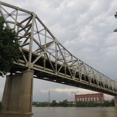
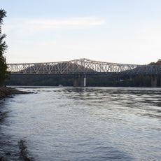
Kenton County is an administrative division in northern Kentucky located where the Licking and Ohio Rivers meet. The territory includes several municipalities, with Covington as its largest city, and features a landscape shaped by river valleys and rolling terrain.

The county was established in 1840 and named after frontiersman Simon Kenton, an early explorer of Kentucky. Its creation was tied to the settlement and expansion of northern Kentucky during the 1800s.

The county's character is shaped by its river towns and industrial heritage, with Covington serving as the cultural anchor for the region's communities. The local identity reflects both the Ohio River's historical importance and the neighborhoods' distinct personalities that developed along its banks.

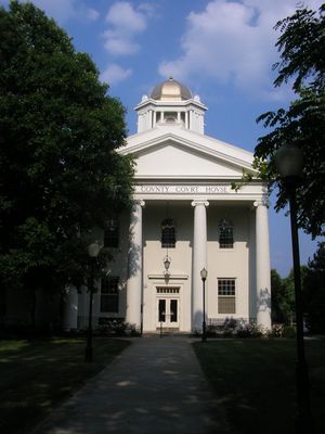
The county operates from two administrative hubs, with government services split between Covington and Independence. Visitors seeking official services should confirm the location of their specific office before traveling.

Until 2010, this was Kentucky's only county with two official county seats operating at the same time. This dual arrangement was a distinction unique among all Kentucky counties.

The community of curious travelers

AroundUs brings together thousands of curated places, local tips, and hidden gems, enriched daily by 60,000 contributors worldwide.

Start exploring
Location
Inception
January 29, 1840
Capital city
Covington
Part of
Cincinnati metropolitan area
Shares border with
Hamilton County, Campbell County, Pendleton County, Grant County, Boone County
GPS coordinates
38.93000,-84.54000
Latest update
December 20, 2025 02:13
Around this place
Paycor Stadium
United States of America

Paycor Stadium

18.5 km
Riverfront Stadium
United States of America

Riverfront Stadium

18.8 km
John A. Roebling Suspension Bridge
United States of America

John A. Roebling Suspension Bridge

18.3 km
Heritage Bank Center
United States of America

Heritage Bank Center

18.9 km
Brent Spence Bridge
United States of America

Brent Spence Bridge

18 km
National Underground Railroad Freedom Center
United States of America

National Underground Railroad Freedom Center

18.9 km
Newport Aquarium
United States of America

Newport Aquarium

18.7 km
Great American Ball Park
United States of America

Great American Ball Park

18.8 km
Great American Tower at Queen City Square
United States of America

Great American Tower at Queen City Square

19.1 km
Brady Music Center
United States of America

Brady Music Center

18.7 km
Cathedral Basilica of the Assumption
United States of America

Cathedral Basilica of the Assumption

16.7 km
The Ascent at Roebling's Bridge
United States of America

The Ascent at Roebling's Bridge

17.9 km
Purple People Bridge
United States of America

Purple People Bridge

19.1 km
PNC Tower
United States of America

PNC Tower

19 km
Clay Wade Bailey Bridge
United States of America

Clay Wade Bailey Bridge

18 km
Taylor–Southgate Bridge
United States of America

Taylor–Southgate Bridge

18.8 km
Fort Washington
United States of America

Fort Washington

19.1 km
Devou Park
United States of America

Devou Park

16.6 km
World Peace Bell
United States of America

World Peace Bell

18.4 km
Scripps Center
United States of America

Scripps Center

19 km
Majestic
United States of America

Majestic

18.9 km
Bavarian Brewing Company
United States of America

Bavarian Brewing Company

16.5 km
Vent Haven Museum
United States of America

Vent Haven Museum

13.7 km
Combs–Hehl Bridge
United States of America

Combs–Hehl Bridge

17.1 km
C&O Railroad Bridge
United States of America

C&O Railroad Bridge

18.1 km
Mother of God Roman Catholic Church
United States of America

Mother of God Roman Catholic Church

17.4 km
Railway Museum of Greater Cincinnati
United States of America

Railway Museum of Greater Cincinnati

13.4 km
Wadsworth Electric Manufacturing Company
United States of America

Wadsworth Electric Manufacturing Company

16.8 km
Show the full map
Reviews
Share your experience

No review yet

Discussions
Start a discussion...

No discussion yet

« Kenton County - Administrative division in northern Kentucky, United States » is provided by Around Us (aroundus.com). Images and texts are derived from Wikimedia project under a Creative Commons license. You are allowed to copy, distribute, and modify copies of this page, under the conditions set by the license, as long as this note is clearly visible.

Discover hidden gems everywhere you go!

From secret cafés to breathtaking viewpoints, skip the crowded tourist spots and find places that match your style. Our app makes it easy with voice search, smart filtering, route optimization, and insider tips from travelers worldwide. Download now for the complete mobile experience.

Around Us App Screenshot

A unique approach to discovering new places

Le Figaro

All the places worth exploring

France Info

A tailor-made excursion in just a few clicks

20 Minutes

Around Us
Travel Guide & Maps
Download

Send to your phone

QR Code
1

Open the camera app on your mobile.

2

Point at the QR code with your camera. A notification will appear.

3

Tap the notification to open the link.