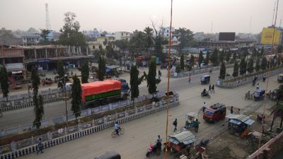
Lahan, municipality in Siraha District, Nepal
Location: Siraha District
Website: http://lahanmun.gov.np
GPS coordinates: 26.71667,86.48333
Latest update: May 15, 2025 13:31
Mount Everest
148.1 km
Khumbu Icefall
147.5 km
Ama Dablam
132.9 km
Janaki Mandir
55.5 km
Nuptse
144.8 km
Sagarmatha National Park
132.4 km
Koshi Barrage
49 km
South Summit
147.8 km
Khumbu Glacier
142.3 km
Imja Tse
141.3 km
Munger Ganga Bridge
146.8 km
Gokyo Ri
140 km
Gauri Sankar
140 km
Tengboche Monastery
127.7 km
Gadhimai
146 km
Maratika Cave
54.5 km
Chinnamasta Bhagawati
27 km
Makalu Barun National Park
127.4 km
Sita Kund
102.2 km
Koshi Tappu Wildlife Reserve
51.9 km
Kangtega
124.1 km
Darbhanga Fort
85.3 km
Budhasubba
82 km
Dolakha Bhimsen Temple
114.3 km
Baruntse
137.7 km
Shyama Mai Temple
84.9 km
Chomo Lonzo
148.5 km
Lhotse Shar
145.6 kmReviews
Visited this place? Tap the stars to rate it and share your experience / photos with the community! Try now! You can cancel it anytime.
Discover hidden gems everywhere you go!
From secret cafés to breathtaking viewpoints, skip the crowded tourist spots and find places that match your style. Our app makes it easy with voice search, smart filtering, route optimization, and insider tips from travelers worldwide. Download now for the complete mobile experience.
A unique approach to discovering new places❞
— Le Figaro
All the places worth exploring❞
— France Info
A tailor-made excursion in just a few clicks❞
— 20 Minutes