Chest opened
+${chestReward.xp} XP
Explorer
NOUVEAU ×${chestReward.collectible.quantity}
tapez pour fermer
Chest locked

Open chests in the app

Around Us is built for your phone — chests unlock when you walk, explore and capture nearby places.

Enable Location

We need your location to show you interesting places around you

Discover nearby places

Find interesting locations and hidden gems around you

Precise directions

Get accurate directions and distances to places

Your location is never shared with other users. It's only used when you tap the location button.

Ottawa National Forest

Log in to your account

Start exploring — it's free

Trusted by 72,880 travelers worldwide

Continue with Google
Continue with Apple
or

We will send you a code to connect

By continuing, you accept our Terms and Conditions and our Privacy Policy

Check your inbox

We've sent a pincode in your inbox. Please enter the code below.

Ottawa National Forest
Discussion Reviews 1 Photos
10.3k Popularity

Ottawa National Forest, National forest in Upper Peninsula, Michigan, United States

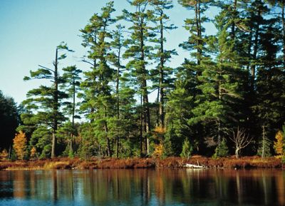
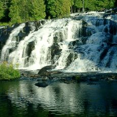
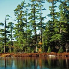
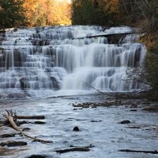
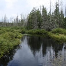
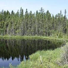
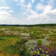
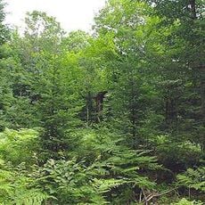
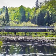
Ottawa National Forest is a large wilderness area in Michigan's Upper Peninsula with dense woodlands, rocky terrain, and a dramatic shoreline along Lake Superior. The landscape includes multiple river systems, numerous waterfalls, and a mix of forests and wetlands spread across the region.

The forest came into being during the 1930s through a series of land acquisitions following the 1854 Treaty of La Pointe, which shaped federal relations with the region. These purchases set the foundation for what is now a protected national forest managed by the federal government.

The Ojibwa people developed deep roots in this forested region over centuries, and their influence shapes how the land is understood and used today. You can sense this legacy through place names and the way the landscape has been cared for.

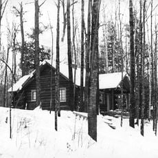
The forest provides trails, waterways, and camping areas for year-round outdoor activities in different seasons. Spring through fall is ideal for hiking and exploring water features, while winter snow creates prime conditions for motorized winter sports and cross-country skiing.

The region receives heavy snowfall each winter, creating landscape transformations that make it exceptional for winter recreation and cross-country skiing. This dramatic seasonal change gives the forest a different character in winter compared to warmer months.

The community of curious travelers

AroundUs brings together thousands of curated places, local tips, and hidden gems, enriched daily by 60,000 contributors worldwide.

Start exploring
Location
GPS coordinates
46.23000,-88.95000
Latest update
December 10, 2025 15:55
Around this place
Bond Falls
United States of America

Bond Falls

24.4 km
Sylvania Wilderness
United States of America

Sylvania Wilderness

26.8 km
Iron County MRA
United States of America

Iron County MRA

37.6 km
Agate Falls Scenic Site
United States of America

Agate Falls Scenic Site

29.9 km
United States of America

Northern Highland-American Legion State Forest

58 km
Bewabic State Park
United States of America

Bewabic State Park

42.8 km
Lake Ellen Kimberlite
United States of America

Lake Ellen Kimberlite

59.9 km
Headwaters Wilderness
United States of America

Headwaters Wilderness

46.3 km
Blackjack Springs Wilderness
United States of America

Blackjack Springs Wilderness

30.3 km
Eagle River Stadium
United States of America

Eagle River Stadium

40.9 km
United States of America

Sturgeon River Gorge Wilderness

46.3 km
Crystal Falls Dam and Power Plant
United States of America

Crystal Falls Dam and Power Plant

49.4 km
United States of America

O Kun de Kun Falls

49.1 km
Sunset Point
United States of America

Sunset Point

40.8 km
Central School
United States of America

Central School

28.3 km
Grandma Lake Wetlands State Natural Area
United States of America

Grandma Lake Wetlands State Natural Area

52.8 km
Franklin Lake Campground
United States of America

Franklin Lake Campground

33.4 km
Canyon Falls Bridge
United States of America

Canyon Falls Bridge

57.4 km
Saint Henry's Evangelical Lutheran Church and Cemetery
United States of America

Saint Henry's Evangelical Lutheran Church and Cemetery

60.9 km
Iron County Courthouse
United States of America

Iron County Courthouse

49.7 km
Forest Route 157–Tamarack River Bridge
United States of America

Forest Route 157–Tamarack River Bridge

2.9 km
Anvil Lake Campground Shelter
United States of America

Anvil Lake Campground Shelter

33.7 km
Bose Lake Hemlock Hardwoods
United States of America

Bose Lake Hemlock Hardwoods

33.2 km
Chicagon Mine Road–Chicagon Creek Bridge
United States of America

Chicagon Mine Road–Chicagon Creek Bridge

37.2 km
Lake Gogebic State Park Beach
United States of America

Lake Gogebic State Park Beach

53.8 km
Lake Gogebic State Park
United States of America

Lake Gogebic State Park

54.4 km
Lake Gogebic
United States of America

Lake Gogebic

57.2 km
M 189 / W 139 Highway Bridge over Brule River
United States of America

M 189 / W 139 Highway Bridge over Brule River

35.4 km
Show the full map
Reviews
Share your experience

No review yet

Discussions
Start a discussion...

No discussion yet

« Ottawa National Forest - National forest in Upper Peninsula, Michigan, United States » is provided by Around Us (aroundus.com). Images and texts are derived from Wikimedia project under a Creative Commons license. You are allowed to copy, distribute, and modify copies of this page, under the conditions set by the license, as long as this note is clearly visible.

Discover hidden gems everywhere you go!

From secret cafés to breathtaking viewpoints, skip the crowded tourist spots and find places that match your style. Our app makes it easy with voice search, smart filtering, route optimization, and insider tips from travelers worldwide. Download now for the complete mobile experience.

Around Us App Screenshot

A unique approach to discovering new places

Le Figaro

All the places worth exploring

France Info

A tailor-made excursion in just a few clicks

20 Minutes

Around Us
Travel Guide & Maps
Download

Send to your phone

QR Code
1

Open the camera app on your mobile.

2

Point at the QR code with your camera. A notification will appear.

3

Tap the notification to open the link.