Chest opened
+${chestReward.xp} XP
Explorer
NOUVEAU ×${chestReward.collectible.quantity}
tapez pour fermer
Chest locked

Open chests in the app

Around Us is built for your phone — chests unlock when you walk, explore and capture nearby places.

Enable Location

We need your location to show you interesting places around you

Discover nearby places

Find interesting locations and hidden gems around you

Precise directions

Get accurate directions and distances to places

Your location is never shared with other users. It's only used when you tap the location button.

Log in to your account

Start exploring — it's free

Trusted by 72,916 travelers worldwide

Continue with Google
Continue with Apple
or

We will send you a code to connect

By continuing, you accept our Terms and Conditions and our Privacy Policy

Check your inbox

We've sent a pincode in your inbox. Please enter the code below.

Westfield High School
Discussion Reviews Photo
18.2k Popularity

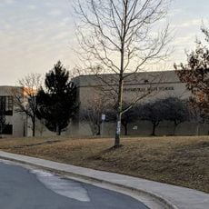
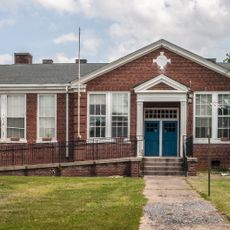
Westfield High School, high school in Chantilly, Virginia

Westfield High School is a public high school in Chantilly, Virginia, serving students in grades 9 through 12. The building includes classrooms, science laboratories, a library, gymnasium facilities, and outdoor areas used for sports and breaks throughout the school day.

The school was founded in the 1960s to serve the growing population of Fairfax County. Over the following decades, the buildings and facilities were expanded several times to keep pace with rising enrollment and changing academic programs.

The school draws students from many neighborhoods across the Chantilly area, and that mix shows clearly in daily life on campus. During breaks, you can see groups sitting together speaking different languages, and clubs that explore music, art, or technology from a wide range of backgrounds.

The school is located in a residential part of Chantilly and is easy to reach by car, with parking available nearby. Visitors who wish to enter the campus should check in with the front office first, as access to school grounds is generally managed during school hours.

The school offers a Junior Reserve Officers Training Corps program, where students can learn leadership and discipline through military-style activities on campus. This kind of program is common across American high schools but often surprises visitors from outside the country.

The community of curious travelers

AroundUs brings together thousands of curated places, local tips, and hidden gems, enriched daily by 60,000 contributors worldwide.

Start exploring
Location
Inception
2000
GPS coordinates
38.88640,-77.46490
Latest update
March 3, 2026 10:14
Around this place
Steven F. Udvar-Hazy Center
United States of America

Steven F. Udvar-Hazy Center

3.3 km
CIA University
United States of America

CIA University

4.8 km
Centreville High School
United States of America

Centreville High School

8.3 km
Sully Historic Site
United States of America

Sully Historic Site

1.9 km
Henry House
United States of America

Henry House

9.4 km
Stone House
United States of America

Stone House

9.2 km
Splash Down Waterpark
United States of America

Splash Down Waterpark

10.3 km
Ox Hill Battlefield Park
United States of America

Ox Hill Battlefield Park

8.6 km
Ellanor C. Lawrence Park
United States of America

Ellanor C. Lawrence Park

4.7 km
Stone Bridge
United States of America

Stone Bridge

7.7 km
Robinson House
United States of America

Robinson House

8.9 km
National Weather Service Baltimore/Washington
United States of America

National Weather Service Baltimore/Washington

10.2 km
Arcola Elementary School
United States of America

Arcola Elementary School

9.3 km
"A" Fort and Battery Hill Redoubt-Camp Early
United States of America

"A" Fort and Battery Hill Redoubt-Camp Early

11.3 km
Ben Lomond Plantation
United States of America

Ben Lomond Plantation

11.5 km
Donald D. Engen Observation Tower
United States of America

Donald D. Engen Observation Tower

3.4 km
United States of America

Culpeper Basin

9.7 km
Arcola Slave Quarters
United States of America

Arcola Slave Quarters

8.8 km
Blackburn's Ford
United States of America

Blackburn's Ford

9.4 km
Merrybrook
United States of America

Merrybrook

9.1 km
Herndon Historic District
United States of America

Herndon Historic District

11.5 km
Frying Pan Meetinghouse
United States of America

Frying Pan Meetinghouse

7.5 km
Cox Farms
United States of America

Cox Farms

2.4 km
Floris Historic District
United States of America

Floris Historic District

7.6 km
Vale School-Community House
United States of America

Vale School-Community House

10.1 km
Children's Science Center Lab
United States of America

Children's Science Center Lab

9.4 km
Amazing Farm Fun
United States of America

Amazing Farm Fun

6.1 km
Henry Hill Visitor Center
United States of America

Henry Hill Visitor Center

9.5 km
Show the full map
Reviews
Share your experience

No review yet

Discussions
Start a discussion...

No discussion yet

« Westfield High School - high school in Chantilly, Virginia » is provided by Around Us (aroundus.com). Images and texts are derived from Wikimedia project under a Creative Commons license. You are allowed to copy, distribute, and modify copies of this page, under the conditions set by the license, as long as this note is clearly visible.

Discover hidden gems everywhere you go!

From secret cafés to breathtaking viewpoints, skip the crowded tourist spots and find places that match your style. Our app makes it easy with voice search, smart filtering, route optimization, and insider tips from travelers worldwide. Download now for the complete mobile experience.

Around Us App Screenshot

A unique approach to discovering new places

Le Figaro

All the places worth exploring

France Info

A tailor-made excursion in just a few clicks

20 Minutes

Around Us
Travel Guide & Maps
Download

Send to your phone

QR Code
1

Open the camera app on your mobile.

2

Point at the QR code with your camera. A notification will appear.

3

Tap the notification to open the link.