
Kōh-e Lālā Shahīd, mountain in Afghanistan
Location: Zabul
Elevation above the sea: 1,865 m
GPS coordinates: 32.31272,67.27021
Latest update: July 12, 2025 03:54
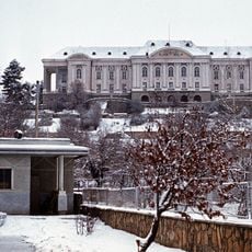
Tajbeg Palace
293.6 km
Band-e Amir National Park
281.3 km
Quaid-e-Azam Residency
219.4 km
Shrine of the Cloak
166.5 km
Kandahar Bilingual Rock Inscription
170.4 km
Forward Operating Base Chapman
276 km
Mundigak
170.8 km
Takht-e-Sulaiman
261.3 km
Tarnak Farms
166.8 km
Gomal Zam Dam
247.1 km
Ghazni Minarets
176.7 km
Citadel of Ghazni
174.8 km
Ziarat Juniper Forest
217.6 km
Tomb of Ahmad Shah Durrani
166.4 km
Palace of Sultan Mas'ud III
177.5 km
Main Operating Base Price
261.7 km
Chil Zena
170.4 km
Shahr-e Zuhak, Bamyan
284.5 km
Band E Sardeh Dam
168 km
Quetta Cantonment
233.5 km
Cultural Landscape and Archaeological Remains of the Bamiyan Valley
285.2 km
Mosque of the Hair of the Prophet
166.6 km
Forward Operating Base Arian
170.2 km
Quetta Fort
235.4 km
Lashkar Gah Mosque
285.5 km
Forward Operating Base Zeebrugge
229.4 km
Shāh Fōlādī
261.5 km
Forward Operating Base Arnhem
283.4 kmReviews
Visited this place? Tap the stars to rate it and share your experience / photos with the community! Try now! You can cancel it anytime.
Discover hidden gems everywhere you go!
From secret cafés to breathtaking viewpoints, skip the crowded tourist spots and find places that match your style. Our app makes it easy with voice search, smart filtering, route optimization, and insider tips from travelers worldwide. Download now for the complete mobile experience.

A unique approach to discovering new places❞
— Le Figaro
All the places worth exploring❞
— France Info
A tailor-made excursion in just a few clicks❞
— 20 Minutes