Chest opened
+${chestReward.xp} XP
Explorer
NOUVEAU ×${chestReward.collectible.quantity}
tapez pour fermer
Chest locked

Open chests in the app

Around Us is built for your phone — chests unlock when you walk, explore and capture nearby places.

Enable Location

We need your location to show you interesting places around you

Discover nearby places

Find interesting locations and hidden gems around you

Precise directions

Get accurate directions and distances to places

Your location is never shared with other users. It's only used when you tap the location button.

Fairway Rock

Log in to your account

Start exploring — it's free

Trusted by 72,888 travelers worldwide

Continue with Google
Continue with Apple
or

We will send you a code to connect

By continuing, you accept our Terms and Conditions and our Privacy Policy

Check your inbox

We've sent a pincode in your inbox. Please enter the code below.

Fairway Rock
Discussion Reviews 1 Photos
12.2k Popularity

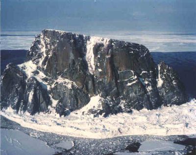
Fairway Rock, Granite island in Bering Strait, Alaska

Fairway Rock is a granite island that rises about 163 meters above sea level and sits southeast of the Diomede Islands in Bering Strait. Sheer rock faces form the edges of this small island in one of the remote regions of Alaska's waters.

Captain James Cook documented the island during his 1778 expedition. Frederick Beechey later named it Fairway Rock in 1826 because it served as a helpful navigation landmark for ships.

The island is known as Ugiiyaq in the Inupiat language and served as a traditional gathering place for seabird eggs during spring nesting seasons.

Reaching this island requires experienced maritime navigation and sturdy vessels because Bering Strait waters are rough and unpredictable. Travelers should only attempt a visit when weather conditions are favorable and calm.

The U.S. Navy installed a radioisotope thermoelectric generator powered by strontium on the island in 1966 to supply power to environmental monitoring instruments. This device is a rare remnant from the era when nuclear power was used to operate remote monitoring stations.

The community of curious travelers

AroundUs brings together thousands of curated places, local tips, and hidden gems, enriched daily by 60,000 contributors worldwide.

Start exploring
Location
Part of
Diomede Islands
GPS coordinates
65.62530,-168.74300
Latest update
December 7, 2025 20:46
Around this place
Whale Bone Alley
Russian Federation

Whale Bone Alley

208 km
Beringia National Park
Russian Federation

Beringia National Park

256 km
United States of America

Ipiutak Site

313.8 km
Monument to Semyon Dezhnev
Russian Federation

Monument to Semyon Dezhnev

62.2 km
Trail Creek Caves
United States of America

Trail Creek Caves

244.6 km
Selawik National Wildlife Refuge
United States of America

Selawik National Wildlife Refuge

444.3 km
Pilgrim Hot Springs
United States of America

Pilgrim Hot Springs

186.9 km
Cape Nome Mining District Discovery Sites
United States of America

Cape Nome Mining District Discovery Sites

197.3 km
Old St. Joseph's Catholic Church
United States of America

Old St. Joseph's Catholic Church

200.5 km
Nome River
United States of America

Nome River

195.4 km
Snake River
United States of America

Snake River

188.8 km
Chamisso Wilderness
United States of America

Chamisso Wilderness

321 km
Wales Site
United States of America

Wales Site

30.3 km
Kougarok River
United States of America

Kougarok River

187.2 km
Squirrel River
United States of America

Squirrel River

385.7 km
Kuzitrin River
United States of America

Kuzitrin River

204 km
Swanberg Dredge
United States of America

Swanberg Dredge

202.5 km
Solomon Roadhouse
United States of America

Solomon Roadhouse

234 km
Niukluk River
United States of America

Niukluk River

237.1 km
Iyatayet Site
United States of America

Iyatayet Site

365.6 km
Kugruk River
United States of America

Kugruk River

281.6 km
Shishmaref Inlet
United States of America

Shishmaref Inlet

148 km
Noxapaga River
United States of America

Noxapaga River

214.8 km
Bureau of Indian Affairs Unalakleet School
United States of America

Bureau of Indian Affairs Unalakleet School

425 km
Slavyanka Cove
Russian Federation

Slavyanka Cove

257.8 km
Историко-культурный комплекс Пловер
Russian Federation

Историко-культурный комплекс Пловер

258.5 km
Kugururok River
United States of America

Kugururok River

439.4 km
Памятный знак в честь 250-летия Первой Камчатской экспедиции (Провидения)
Russian Federation

Памятный знак в честь 250-летия Первой Камчатской экспедиции (Провидения)

250.7 km
Show the full map
Reviews
Share your experience

No review yet

Discussions
Start a discussion...

No discussion yet

« Fairway Rock - Granite island in Bering Strait, Alaska » is provided by Around Us (aroundus.com). Images and texts are derived from Wikimedia project under a Creative Commons license. You are allowed to copy, distribute, and modify copies of this page, under the conditions set by the license, as long as this note is clearly visible.

Discover hidden gems everywhere you go!

From secret cafés to breathtaking viewpoints, skip the crowded tourist spots and find places that match your style. Our app makes it easy with voice search, smart filtering, route optimization, and insider tips from travelers worldwide. Download now for the complete mobile experience.

Around Us App Screenshot

A unique approach to discovering new places

Le Figaro

All the places worth exploring

France Info

A tailor-made excursion in just a few clicks

20 Minutes

Around Us
Travel Guide & Maps
Download

Send to your phone

QR Code
1

Open the camera app on your mobile.

2

Point at the QR code with your camera. A notification will appear.

3

Tap the notification to open the link.