Chest opened
+${chestReward.xp} XP
Explorer
NOUVEAU ×${chestReward.collectible.quantity}
tapez pour fermer
Chest locked

Open chests in the app

Around Us is built for your phone — chests unlock when you walk, explore and capture nearby places.

Enable Location

We need your location to show you interesting places around you

Discover nearby places

Find interesting locations and hidden gems around you

Precise directions

Get accurate directions and distances to places

Your location is never shared with other users. It's only used when you tap the location button.

Russia–United States border

Log in to your account

Start exploring — it's free

Trusted by 72,998 travelers worldwide

Continue with Google
Continue with Apple
or

We will send you a code to connect

By continuing, you accept our Terms and Conditions and our Privacy Policy

Check your inbox

We've sent a pincode in your inbox. Please enter the code below.

Discussion Reviews 1 Photos
23.5k Popularity

Russia–United States border, maritime border

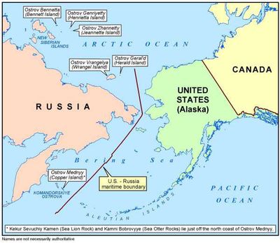
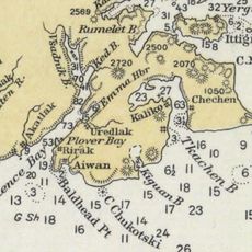
The Russia-United States border in Alaska is an international boundary that separates the two nations by both land and sea. It spans approximately 168 km (104 miles) across the Bering Strait and includes a land boundary in the Yukon Triangle region.

This border was established in 1867 when the United States purchased Alaska from Russia, redrawing the political boundaries between the two nations. The maritime boundary in the Bering Sea was later formalized through modern international agreements.

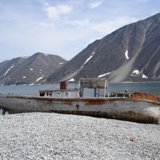
The border is generally not directly accessible as it crosses open waters of the Bering Strait and is marked by harsh weather conditions. Visitors can explore this region only with special permits and often only by boat or plane.

The two Diomede Islands in the Bering Strait lie only about 3.8 km (2.4 miles) apart, with one belonging to Russia and the other to the United States. Local residents can see each other on clear days but are completely separated by the international boundary.

The community of curious travelers

AroundUs brings together thousands of curated places, local tips, and hidden gems, enriched daily by 60,000 contributors worldwide.

Start exploring
Location
Part of
borders of Russia, borders of the United States
GPS coordinates
65.50000,-168.97700
Latest update
December 20, 2025 14:12
Around this place
Whale Bone Alley
Russian Federation

Whale Bone Alley

191.8 km
Beringia National Park
Russian Federation

Beringia National Park

239.7 km
United States of America

Ipiutak Site

330.1 km
Monument to Semyon Dezhnev
Russian Federation

Monument to Semyon Dezhnev

66.8 km
Trail Creek Caves
United States of America

Trail Creek Caves

257.2 km
Pilgrim Hot Springs
United States of America

Pilgrim Hot Springs

193.9 km
Cape Nome Mining District Discovery Sites
United States of America

Cape Nome Mining District Discovery Sites

198.9 km
Old St. Joseph's Catholic Church
United States of America

Old St. Joseph's Catholic Church

201.4 km
Nome River
United States of America

Nome River

197.9 km
Snake River
United States of America

Snake River

190.8 km
Chamisso Wilderness
United States of America

Chamisso Wilderness

335.2 km
Wales Site
United States of America

Wales Site

42.8 km
Cape Vankarem
Russian Federation

Cape Vankarem

398.3 km
Kougarok River
United States of America

Kougarok River

197.7 km
Squirrel River
United States of America

Squirrel River

402.3 km
Kuzitrin River
United States of America

Kuzitrin River

213.3 km
Swanberg Dredge
United States of America

Swanberg Dredge

203.5 km
Solomon Roadhouse
United States of America

Solomon Roadhouse

237.5 km
Niukluk River
United States of America

Niukluk River

244 km
Iyatayet Site
United States of America

Iyatayet Site

371.8 km
Kugruk River
United States of America

Kugruk River

294.7 km
Shishmaref Inlet
United States of America

Shishmaref Inlet

164.5 km
Noxapaga River
United States of America

Noxapaga River

226.3 km
Bureau of Indian Affairs Unalakleet School
United States of America

Bureau of Indian Affairs Unalakleet School

429.6 km
Slavyanka Cove
Russian Federation

Slavyanka Cove

241.5 km
Историко-культурный комплекс Пловер
Russian Federation

Историко-культурный комплекс Пловер

242.2 km
Kugururok River
United States of America

Kugururok River

456.9 km
Памятный знак в честь 250-летия Первой Камчатской экспедиции (Провидения)
Russian Federation

Памятный знак в честь 250-летия Первой Камчатской экспедиции (Провидения)

234.5 km
Show the full map
Reviews
Share your experience

No review yet

Discussions
Start a discussion...

No discussion yet

« Russia–United States border - maritime border » is provided by Around Us (aroundus.com). Images and texts are derived from Wikimedia project under a Creative Commons license. You are allowed to copy, distribute, and modify copies of this page, under the conditions set by the license, as long as this note is clearly visible.

Discover hidden gems everywhere you go!

From secret cafés to breathtaking viewpoints, skip the crowded tourist spots and find places that match your style. Our app makes it easy with voice search, smart filtering, route optimization, and insider tips from travelers worldwide. Download now for the complete mobile experience.

Around Us App Screenshot

A unique approach to discovering new places

Le Figaro

All the places worth exploring

France Info

A tailor-made excursion in just a few clicks

20 Minutes

Around Us
Travel Guide & Maps
Download

Send to your phone

QR Code
1

Open the camera app on your mobile.

2

Point at the QR code with your camera. A notification will appear.

3

Tap the notification to open the link.