Chest opened
+${chestReward.xp} XP
Explorer
NOUVEAU ×${chestReward.collectible.quantity}
tapez pour fermer
Chest locked

Open chests in the app

Around Us is built for your phone — chests unlock when you walk, explore and capture nearby places.

Enable Location

We need your location to show you interesting places around you

Discover nearby places

Find interesting locations and hidden gems around you

Precise directions

Get accurate directions and distances to places

Your location is never shared with other users. It's only used when you tap the location button.

Kotzebue Sound

Log in to your account

Start exploring — it's free

Trusted by 72,876 travelers worldwide

Continue with Google
Continue with Apple
or

We will send you a code to connect

By continuing, you accept our Terms and Conditions and our Privacy Policy

Check your inbox

We've sent a pincode in your inbox. Please enter the code below.

Kotzebue Sound
Discussion Reviews 1 Photos
8.7k Popularity

Kotzebue Sound, Bay in Northwest Arctic Region, United States.

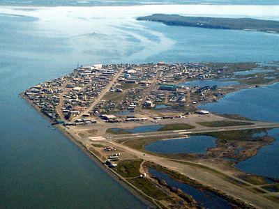
Kotzebue Sound is a bay in northwestern Alaska, north of the Arctic Circle, where the Noatak, Kobuk, and Selawik Rivers empty into the Chukchi Sea. Its shores are mostly flat and low, bordered by tundra, and the town of Kotzebue sits near its entrance on a narrow spit of land.

The Russian navigator Otto von Kotzebue gave this bay its name after he sailed through in 1818 while looking for the Northwest Passage, and his charts helped open the area to outside knowledge. Long before his arrival, Iñupiat communities had lived along these shores for thousands of years.

The Iñupiat people who live along these shores still hunt beluga whales and fish using methods passed down over generations. Visitors who travel to nearby communities can often see traditional techniques in practice, from net fishing to the preparation of dried fish.

Kotzebue is the starting point for any visit to this area and can only be reached by plane, since there are no roads connecting it to the rest of Alaska. Boat trips on the water are possible in summer, when daylight lasts for many hours and the ice has melted.

The bay is surprisingly shallow across much of its surface, which keeps large vessels away and makes it feel more like an inland lake than an open sea approach. This shallow depth is also why it freezes so thoroughly in winter, forming ice thick enough to support the weight of loaded sleds and small vehicles.

The community of curious travelers

AroundUs brings together thousands of curated places, local tips, and hidden gems, enriched daily by 60,000 contributors worldwide.

Start exploring
GPS coordinates
66.63232,-162.78515
Latest update
March 3, 2026 08:19
Around this place
Kobuk Valley National Park
United States of America

Kobuk Valley National Park

182.9 km
United States of America

Ipiutak Site

256.6 km
Monument to Semyon Dezhnev
Russian Federation

Monument to Semyon Dezhnev

316.8 km
Trail Creek Caves
United States of America

Trail Creek Caves

97.8 km
Noatak Wilderness
United States of America

Noatak Wilderness

211.2 km
Koyukuk National Wildlife Refuge
United States of America

Koyukuk National Wildlife Refuge

306.3 km
Selawik National Wildlife Refuge
United States of America

Selawik National Wildlife Refuge

160 km
Pilgrim Hot Springs
United States of America

Pilgrim Hot Springs

197.1 km
Cape Nome Mining District Discovery Sites
United States of America

Cape Nome Mining District Discovery Sites

259.1 km
Old St. Joseph's Catholic Church
United States of America

Old St. Joseph's Catholic Church

266.3 km
Selawik River
United States of America

Selawik River

195.6 km
Nome River
United States of America

Nome River

249.1 km
Snake River
United States of America

Snake River

254 km
Chamisso Wilderness
United States of America

Chamisso Wilderness

62.4 km
Onion Portage Archeological District
United States of America

Onion Portage Archeological District

202.9 km
Wales Site
United States of America

Wales Site

264.6 km
Kougarok River
United States of America

Kougarok River

155.9 km
Squirrel River
United States of America

Squirrel River

102.4 km
Kuzitrin River
United States of America

Kuzitrin River

164.1 km
Swanberg Dredge
United States of America

Swanberg Dredge

266.2 km
Solomon Roadhouse
United States of America

Solomon Roadhouse

243 km
Niukluk River
United States of America

Niukluk River

195.9 km
Iyatayet Site
United States of America

Iyatayet Site

254.3 km
Kugruk River
United States of America

Kugruk River

83.4 km
Shishmaref Inlet
United States of America

Shishmaref Inlet

143.8 km
Salmon River
United States of America

Salmon River

163.4 km
Noxapaga River
United States of America

Noxapaga River

129.2 km
Bureau of Indian Affairs Unalakleet School
United States of America

Bureau of Indian Affairs Unalakleet School

321.1 km
Show the full map
Reviews
Share your experience

No review yet

Discussions
Start a discussion...

No discussion yet

« Kotzebue Sound - Bay in Northwest Arctic Region, United States » is provided by Around Us (aroundus.com). Images and texts are derived from Wikimedia project under a Creative Commons license. You are allowed to copy, distribute, and modify copies of this page, under the conditions set by the license, as long as this note is clearly visible.

Discover hidden gems everywhere you go!

From secret cafés to breathtaking viewpoints, skip the crowded tourist spots and find places that match your style. Our app makes it easy with voice search, smart filtering, route optimization, and insider tips from travelers worldwide. Download now for the complete mobile experience.

Around Us App Screenshot

A unique approach to discovering new places

Le Figaro

All the places worth exploring

France Info

A tailor-made excursion in just a few clicks

20 Minutes

Around Us
Travel Guide & Maps
Download

Send to your phone

QR Code
1

Open the camera app on your mobile.

2

Point at the QR code with your camera. A notification will appear.

3

Tap the notification to open the link.