Chest opened
+${chestReward.xp} XP
Explorer
NOUVEAU ×${chestReward.collectible.quantity}
tapez pour fermer
Chest locked

Open chests in the app

Around Us is built for your phone — chests unlock when you walk, explore and capture nearby places.

Enable Location

We need your location to show you interesting places around you

Discover nearby places

Find interesting locations and hidden gems around you

Precise directions

Get accurate directions and distances to places

Your location is never shared with other users. It's only used when you tap the location button.

Bering Land Bridge National Preserve

Log in to your account

Start exploring — it's free

Trusted by 73,046 travelers worldwide

Continue with Google
Continue with Apple
or

We will send you a code to connect

By continuing, you accept our Terms and Conditions and our Privacy Policy

Check your inbox

We've sent a pincode in your inbox. Please enter the code below.

Bering Land Bridge National Preserve
Discussion Reviews 1 Photos
11.9k Popularity

Bering Land Bridge National Preserve, National preserve in Northwest Arctic Borough, United States.

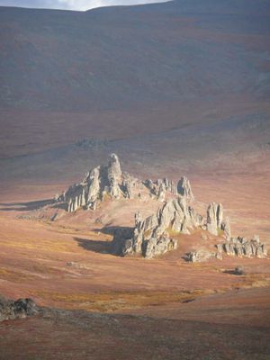
Bering Land Bridge National Preserve is a protected area on Alaska's Seward Peninsula, encompassing tundra lowlands, volcanic cones, and shoreline along the Bering Sea. The terrain is windswept and open, with scattered volcanic features rising from the flat landscape.

This area was once part of a land bridge connecting Asia and North America during the last ice age, allowing animals and humans to migrate between continents. The land connection disappeared thousands of years ago as sea levels rose after the ice melted.

The Iñupiat and Yupik peoples in nearby villages have hunted and fished these lands for thousands of years. Today, you can see how these communities continue to rely on the preserve's resources for food and materials.

Summer is the main season for visits, when warmer temperatures make travel easier and the land is more accessible. Visitors should prepare for harsh weather, remote conditions, and the lack of facilities or services in the area.

The preserve features active volcanic phenomena including crater lakes called maars and natural hot springs that dot the tundra landscape. These geothermal features create striking contrasts against the otherwise frozen and barren terrain.

The community of curious travelers

AroundUs brings together thousands of curated places, local tips, and hidden gems, enriched daily by 60,000 contributors worldwide.

Start exploring
Inception
December 1, 1978
GPS coordinates
65.83330,-164.16700
Latest update
December 7, 2025 20:48
Around this place
Kobuk Valley National Park
United States of America

Kobuk Valley National Park

287.6 km
United States of America

Ipiutak Site

302.1 km
Monument to Semyon Dezhnev
Russian Federation

Monument to Semyon Dezhnev

252.4 km
Trail Creek Caves
United States of America

Trail Creek Caves

34.6 km
Selawik National Wildlife Refuge
United States of America

Selawik National Wildlife Refuge

239.5 km
Cape Nome Mining District Discovery Sites
United States of America

Cape Nome Mining District Discovery Sites

152.1 km
Unalakleet River
United States of America

Unalakleet River

286.2 km
Old St. Joseph's Catholic Church
United States of America

Old St. Joseph's Catholic Church

159.4 km
Selawik River
United States of America

Selawik River

270.7 km
Nome River
United States of America

Nome River

142.1 km
Snake River
United States of America

Snake River

146.3 km
Chamisso Wilderness
United States of America

Chamisso Wilderness

114.5 km
Onion Portage Archeological District
United States of America

Onion Portage Archeological District

296.2 km
Wales Site
United States of America

Wales Site

181.1 km
Kougarok River
United States of America

Kougarok River

47.5 km
Squirrel River
United States of America

Squirrel River

210.2 km
Kuzitrin River
United States of America

Kuzitrin River

59 km
Swanberg Dredge
United States of America

Swanberg Dredge

159.4 km
Solomon Roadhouse
United States of America

Solomon Roadhouse

142.4 km
Niukluk River
United States of America

Niukluk River

100.6 km
Iyatayet Site
United States of America

Iyatayet Site

201.4 km
Kugruk River
United States of America

Kugruk River

71 km
Shishmaref Inlet
United States of America

Shishmaref Inlet

91.7 km
Salmon River
United States of America

Salmon River

269.1 km
Noxapaga River
United States of America

Noxapaga River

26.9 km
Bureau of Indian Affairs Unalakleet School
United States of America

Bureau of Indian Affairs Unalakleet School

270.7 km
Kugururok River
United States of America

Kugururok River

302.6 km
Bering Land Bridge Visitor Center
United States of America

Bering Land Bridge Visitor Center

159.6 km
Show the full map
Reviews
Share your experience

No review yet

Discussions
Start a discussion...

No discussion yet

« Bering Land Bridge National Preserve - National preserve in Northwest Arctic Borough, United States » is provided by Around Us (aroundus.com). Images and texts are derived from Wikimedia project under a Creative Commons license. You are allowed to copy, distribute, and modify copies of this page, under the conditions set by the license, as long as this note is clearly visible.

Discover hidden gems everywhere you go!

From secret cafés to breathtaking viewpoints, skip the crowded tourist spots and find places that match your style. Our app makes it easy with voice search, smart filtering, route optimization, and insider tips from travelers worldwide. Download now for the complete mobile experience.

Around Us App Screenshot

A unique approach to discovering new places

Le Figaro

All the places worth exploring

France Info

A tailor-made excursion in just a few clicks

20 Minutes

Around Us
Travel Guide & Maps
Download

Send to your phone

QR Code
1

Open the camera app on your mobile.

2

Point at the QR code with your camera. A notification will appear.

3

Tap the notification to open the link.