Coffre ${chestReward.rarityLabel}
+${chestReward.xp} XP
Explorer
NOUVEAU ×${chestReward.collectible.quantity}
tapez pour fermer
Chest locked

Open chests in the app

Around Us is built for your phone — chests unlock when you walk, explore and capture nearby places.

Enable Location

We need your location to show you interesting places around you

Discover nearby places

Find interesting locations and hidden gems around you

Precise directions

Get accurate directions and distances to places

Your location is never shared with other users. It's only used when you tap the location button.

Log in to your account

Start exploring — it's free

Trusted by 72,393 travelers worldwide

Continue with Google
Continue with Apple
or

We will send you a code to connect

By continuing, you accept our Terms and Conditions and our Privacy Policy

Check your inbox

We've sent a pincode in your inbox. Please enter the code below.

Andreafsky Wilderness
Discussion Reviews Photo
2k Popularity

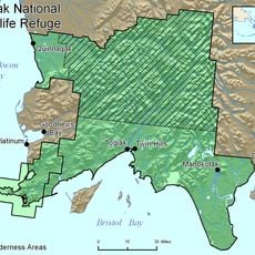
Andreafsky Wilderness, Protected wilderness area in Alaska, United States.

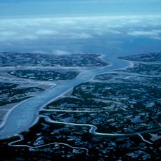
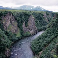
Andreafsky Wilderness is a protected area in Alaska's Yukon Delta, characterized by flat wetland tundra that transitions to higher ground in the south, with the Andreafsky River and East Fork running roughly parallel. Together these waterways form the dominant features of the landscape.

This area became federally protected in 1980 as part of the Alaska National Interest Lands Conservation Act, which established it within the Yukon Delta National Wildlife Refuge. The legislation reflected growing concern for preserving Alaska's natural ecosystems.

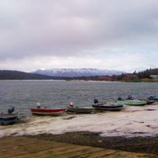
Yup'ik communities in nearby settlements depend on the rivers for salmon fishing, a practice that has shaped life in the region for generations. The waterways remain central to local food sources and seasonal rhythms.

Reaching this wilderness requires flying to Bethel Airport and then arranging water or helicopter transport, as no roads lead to the area. Weather conditions can be unpredictable and facilities within the refuge are minimal.

Two of the world's only known breeding sites for Bristle-thighed Curlews are located here, and these rare birds undertake one of the longest uninterrupted migrations of any bird species. Each year they depart for the Pacific islands and return to nest in the same locations.

The community of curious travelers

AroundUs brings together thousands of curated places, local tips, and hidden gems, enriched daily by 60,000 contributors worldwide.

Start exploring
Location
GPS coordinates
62.61670,-162.60000
Latest update
December 14, 2025 11:05
Around this place
Yukon Delta National Wildlife Refuge
United States of America

Yukon Delta National Wildlife Refuge

181.1 km
Wood-Tikchik State Park
United States of America

Wood-Tikchik State Park

354.7 km
Togiak National Wildlife Refuge
United States of America

Togiak National Wildlife Refuge

386.8 km
Innoko National Wildlife Refuge
United States of America

Innoko National Wildlife Refuge

226.1 km
Trail Creek Caves
United States of America

Trail Creek Caves

355.6 km
Togiak Wilderness
United States of America

Togiak Wilderness

355.9 km
Innoko Wilderness
United States of America

Innoko Wilderness

223.3 km
Pilgrim Hot Springs
United States of America

Pilgrim Hot Springs

298.2 km
Cape Nome Mining District Discovery Sites
United States of America

Cape Nome Mining District Discovery Sites

256.5 km
Unalakleet River
United States of America

Unalakleet River

202.6 km
Old St. Joseph's Catholic Church
United States of America

Old St. Joseph's Catholic Church

251.6 km
Nome River
United States of America

Nome River

261.7 km
Snake River
United States of America

Snake River

265.7 km
Kougarok River
United States of America

Kougarok River

333.3 km
Kuzitrin River
United States of America

Kuzitrin River

312.5 km
Christ Church Mission
United States of America

Christ Church Mission

122.8 km
Swanberg Dredge
United States of America

Swanberg Dredge

249.8 km
Solomon Roadhouse
United States of America

Solomon Roadhouse

234.6 km
Niukluk River
United States of America

Niukluk River

266.1 km
Iyatayet Site
United States of America

Iyatayet Site

206.7 km
St. Jacob's Church
United States of America

St. Jacob's Church

217 km
Kugruk River
United States of America

Kugruk River

364 km
Sts. Constantine and Helen Chapel
United States of America

Sts. Constantine and Helen Chapel

399.8 km
St. Seraphim Chapel
United States of America

St. Seraphim Chapel

169.6 km
Noxapaga River
United States of America

Noxapaga River

339.1 km
Bureau of Indian Affairs Unalakleet School
United States of America

Bureau of Indian Affairs Unalakleet School

166.7 km
Johnson River
United States of America

Johnson River

143.8 km
Kemuk River
United States of America

Kemuk River

370.7 km
Show the full map
Reviews
Share your experience

No review yet

Discussions
Start a discussion...

No discussion yet

« Andreafsky Wilderness - Protected wilderness area in Alaska, United States » is provided by Around Us (aroundus.com). Images and texts are derived from Wikimedia project under a Creative Commons license. You are allowed to copy, distribute, and modify copies of this page, under the conditions set by the license, as long as this note is clearly visible.

Discover hidden gems everywhere you go!

From secret cafés to breathtaking viewpoints, skip the crowded tourist spots and find places that match your style. Our app makes it easy with voice search, smart filtering, route optimization, and insider tips from travelers worldwide. Download now for the complete mobile experience.

Around Us App Screenshot

A unique approach to discovering new places

Le Figaro

All the places worth exploring

France Info

A tailor-made excursion in just a few clicks

20 Minutes

Around Us
Travel Guide & Maps
Download

Send to your phone

QR Code
1

Open the camera app on your mobile.

2

Point at the QR code with your camera. A notification will appear.

3

Tap the notification to open the link.