Chest opened
+${chestReward.xp} XP
Explorer
NOUVEAU ×${chestReward.collectible.quantity}
tapez pour fermer
Chest locked

Open chests in the app

Around Us is built for your phone — chests unlock when you walk, explore and capture nearby places.

Enable Location

We need your location to show you interesting places around you

Discover nearby places

Find interesting locations and hidden gems around you

Precise directions

Get accurate directions and distances to places

Your location is never shared with other users. It's only used when you tap the location button.

Log in to your account

Start exploring — it's free

Trusted by 73,053 travelers worldwide

Continue with Google
Continue with Apple
or

We will send you a code to connect

By continuing, you accept our Terms and Conditions and our Privacy Policy

Check your inbox

We've sent a pincode in your inbox. Please enter the code below.

California's 29th congressional district
Discussion Reviews Photo
32.4k Popularity

California's 29th congressional district, Congressional district in San Fernando Valley, California, United States

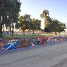
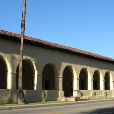
California's 29th congressional district covers several neighborhoods in the San Fernando Valley, including Van Nuys, Pacoima, Arleta, Panorama City, Sylmar, and North Hollywood. These communities are all located in the northern part of Los Angeles and together form the boundaries of this representative area.

The district was established in 1953 and has been represented by different members in Congress since its creation. Over the years, its boundaries have changed as the area developed and grew.

The area is shaped by residents from many different backgrounds who live and work together in these neighborhoods. You can see this diversity reflected in the shops, restaurants, and community events throughout the district.

Residents can find information about their representation and voting locations in their area. It helps to contact local government offices or check official websites for current details about elections and civic participation.

The district has a strong voter base with consistent political leanings that are visible in election results year after year. These preferences have remained relatively stable over an extended period.

The community of curious travelers

AroundUs brings together thousands of curated places, local tips, and hidden gems, enriched daily by 60,000 contributors worldwide.

Start exploring
Location
GPS coordinates
34.26667,-118.43028
Latest update
December 20, 2025 00:30
Around this place
Mission San Fernando Rey de España
United States of America

Mission San Fernando Rey de España

2.9 km
Golden Oak Ranch
United States of America

Golden Oak Ranch

12.7 km
Sepulveda Dam
United States of America

Sepulveda Dam

11.8 km
Grace Community Church
United States of America

Grace Community Church

5.1 km
Nethercutt Collection
United States of America

Nethercutt Collection

5.4 km
The Great Wall of Los Angeles
United States of America

The Great Wall of Los Angeles

9.9 km
The Japanese Garden
United States of America

The Japanese Garden

10.3 km
Placerita Canyon State Park
United States of America

Placerita Canyon State Park

12.2 km
Shepherd of the Hills Church
United States of America

Shepherd of the Hills Church

12.4 km
Portal of the Folded Wings Shrine to Aviation
United States of America

Portal of the Folded Wings Shrine to Aviation

10.7 km
17 Hertz Studio
United States of America

17 Hertz Studio

12.2 km
Matadome
United States of America

Matadome

9.2 km
Pacoima Dam
United States of America

Pacoima Dam

8.2 km
Rómulo Pico Adobe
United States of America

Rómulo Pico Adobe

3.4 km
United States of America

Van Nuys City Hall

9.3 km
Convento Building
United States of America

Convento Building

2.9 km
O'Melveny Park
United States of America

O'Melveny Park

9.7 km
Sylmar Converter Station
United States of America

Sylmar Converter Station

6.9 km
California State University Northridge Botanic Garden
United States of America

California State University Northridge Botanic Garden

9.4 km
Lopez Adobe
United States of America

Lopez Adobe

2 km
San Fernando Pioneer Memorial Cemetery
United States of America

San Fernando Pioneer Memorial Cemetery

6.2 km
Cathedral of St. Mary Byzantine Catholic Church
United States of America

Cathedral of St. Mary Byzantine Catholic Church

11.5 km
North Hollywood Amelia Earhart Regional Library
United States of America

North Hollywood Amelia Earhart Regional Library

12.2 km
Van Nuys Branch
United States of America

Van Nuys Branch

9.3 km
St. Leon Cathedral
United States of America

St. Leon Cathedral

10.6 km
Valley Relics Museum
United States of America

Valley Relics Museum

8.7 km
El Portal Theatre
United States of America

El Portal Theatre

12.2 km
Playtime Co.
United States of America

Playtime Co.

8.8 km
Show the full map
Reviews
Share your experience

No review yet

Discussions
Start a discussion...

No discussion yet

« California's 29th congressional district - Congressional district in San Fernando Valley, California, United States » is provided by Around Us (aroundus.com). Images and texts are derived from Wikimedia project under a Creative Commons license. You are allowed to copy, distribute, and modify copies of this page, under the conditions set by the license, as long as this note is clearly visible.

Discover hidden gems everywhere you go!

From secret cafés to breathtaking viewpoints, skip the crowded tourist spots and find places that match your style. Our app makes it easy with voice search, smart filtering, route optimization, and insider tips from travelers worldwide. Download now for the complete mobile experience.

Around Us App Screenshot

A unique approach to discovering new places

Le Figaro

All the places worth exploring

France Info

A tailor-made excursion in just a few clicks

20 Minutes

Around Us
Travel Guide & Maps
Download

Send to your phone

QR Code
1

Open the camera app on your mobile.

2

Point at the QR code with your camera. A notification will appear.

3

Tap the notification to open the link.