Enable Location

We need your location to show you interesting places around you

Discover nearby places

Find interesting locations and hidden gems around you

Precise directions

Get accurate directions and distances to places

Your location is never shared with other users. It's only used when you tap the location button.

Margarita Peak

Log in to your account

Start exploring — it's free

Trusted by 61,553 travelers worldwide

Continue with Google
Continue with Apple
or

We will send you a code to connect

By continuing, you accept our Terms and Conditions and our Privacy Policy

Check your inbox

We've sent a pincode in your inbox. Please enter the code below.

Margarita Peak

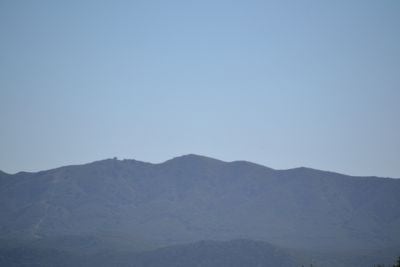
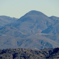
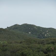
Margarita Peak, Mountain summit in San Diego County, California.

Description

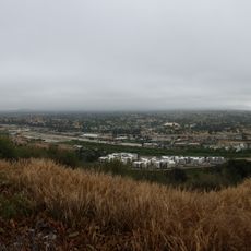
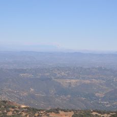
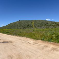
Margarita Peak is a mountain summit in the Santa Ana Mountains standing at about 3,200 feet. From the top, you can see across Southern California's valleys and toward the Pacific coast.

History

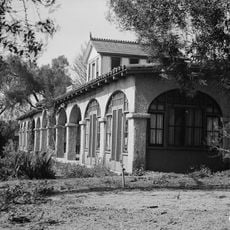
The Fallbrook Land Conservancy acquired this area to protect natural habitats and support scientific research activities. This protection has significantly limited public access to the summit.

Culture

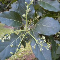
The peak serves as a research site where scientists study native California plant species and wildlife patterns in their natural environment.

Practical

The hike covers roughly 3 miles on open roads without shade, then continues through thick brush and steep slopes to reach the summit. Access to the area is limited and requires advance planning with local authorities.

Did you know?

Fewer than a dozen visitors reach this summit annually, making it one of Southern California's loneliest mountains. This isolation allows the landscape to remain largely untouched by human activity.

Location
GPS coordinates
33.44452,-117.39058
Latest update
December 13, 2025 12:20

AroundUs brings together thousands of curated places, local tips, and hidden gems, enriched daily by 60,000 contributors worldwide. Discover all places nearby (California).

Around this place
Mission San Juan Capistrano
United States of America

Mission San Juan Capistrano

26.1 km
Mission San Luis Rey de Francia
United States of America

Mission San Luis Rey de Francia

24.5 km
La Casa Pacifica
United States of America

La Casa Pacifica

20.1 km
San Onofre State Beach
United States of America

San Onofre State Beach

18.4 km
Doheny State Beach
United States of America

Doheny State Beach

26.8 km
Mission Basilica San Juan Capistrano
United States of America

Mission Basilica San Juan Capistrano

26.2 km
Mount Ecclesia
United States of America

Mount Ecclesia

26.1 km
Casa Romantica
United States of America

Casa Romantica

21.5 km
El Adobe de Capistrano
United States of America

El Adobe de Capistrano

26 km
Temecula Valley
United States of America

Temecula Valley

23.4 km
WWII/Korea LVT Museum
United States of America

WWII/Korea LVT Museum

25.2 km
Los Rios Street Historic District
United States of America

Los Rios Street Historic District

26.1 km
Rancho Guajome Adobe
United States of America

Rancho Guajome Adobe

26.7 km
Trestles Bridge
United States of America

Trestles Bridge

20 km
Redonda Mesa
United States of America

Redonda Mesa

6.7 km
United States of America

Railroad Canyon

25.8 km
Goldschmidt House
United States of America

Goldschmidt House

20.4 km
Los Pinos Peak
United States of America

Los Pinos Peak

25.6 km
Richard Egan House
United States of America

Richard Egan House

26 km
San Mateo Peak
United States of America

San Mateo Peak

18.8 km
Temecula's Chapel of Memories
United States of America

Temecula's Chapel of Memories

23 km
Caruso Memorial Chapel
United States of America

Caruso Memorial Chapel

11 km
Esslinger Building
United States of America

Esslinger Building

25.9 km
Frank A. Forster House
United States of America

Frank A. Forster House

25.4 km
Greystone Villa-Cabin 18
United States of America

Greystone Villa-Cabin 18

19.3 km
Rome Hill
United States of America

Rome Hill

21.8 km
Finca y jardines Grand Tradition
United States of America

Finca y jardines Grand Tradition

16.5 km
Reserva Botánica de Laguna Niguel
United States of America

Reserva Botánica de Laguna Niguel

14.1 km
Show the full map
« Margarita Peak - Mountain summit in San Diego County, California » is provided by Around Us (aroundus.com). Images and texts are derived from Wikimedia project under a Creative Commons license. You are allowed to copy, distribute, and modify copies of this page, under the conditions set by the license, as long as this note is clearly visible.

Discover hidden gems everywhere you go!

From secret cafés to breathtaking viewpoints, skip the crowded tourist spots and find places that match your style. Our app makes it easy with voice search, smart filtering, route optimization, and insider tips from travelers worldwide. Download now for the complete mobile experience.

Around Us App Screenshot

A unique approach to discovering new places

Le Figaro

All the places worth exploring

France Info

A tailor-made excursion in just a few clicks

20 Minutes

Around Us
Travel Guide & Maps
Download

Send to your phone

QR Code
1

Open the camera app on your mobile.

2

Point at the QR code with your camera. A notification will appear.

3

Tap the notification to open the link.