Chest opened
+${chestReward.xp} XP
Explorer
NOUVEAU ×${chestReward.collectible.quantity}
tapez pour fermer
Chest locked

Open chests in the app

Around Us is built for your phone — chests unlock when you walk, explore and capture nearby places.

Enable Location

We need your location to show you interesting places around you

Discover nearby places

Find interesting locations and hidden gems around you

Precise directions

Get accurate directions and distances to places

Your location is never shared with other users. It's only used when you tap the location button.

Chocolate Mountain Aerial Gunnery Range

Log in to your account

Start exploring — it's free

Trusted by 73,009 travelers worldwide

Continue with Google
Continue with Apple
or

We will send you a code to connect

By continuing, you accept our Terms and Conditions and our Privacy Policy

Check your inbox

We've sent a pincode in your inbox. Please enter the code below.

Chocolate Mountain Aerial Gunnery Range
Discussion Reviews 1 Photos
15.9k Popularity

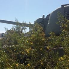
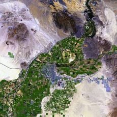
Chocolate Mountain Aerial Gunnery Range, military exercise area in California

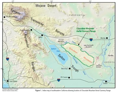
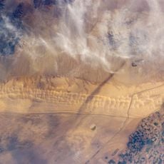
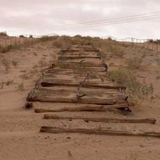
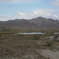
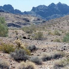
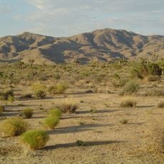
Chocolate Mountain Aerial Gunnery Range is a vast military training facility in southeastern California covering roughly 460,000 acres east of the Salton Sea. The terrain consists of desert landscape with rocky hills and flat open spaces where five target zones are designated for various training exercises involving aircraft and ground operations.

Military pilots have trained at this range since World War II, making it a longstanding facility for US armed forces preparation. Control of the area was transferred to the Navy in 2014 to continue supporting military training exercises in this remote location.

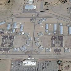
The facility is closed to the public and requires military authorization for any access to the grounds. Airspace is restricted to military aircraft during training operations, so visitors must respect all warning signs and maintain distance from the perimeter.

An old trading route called the Bradshaw Trail runs along the range's northern edge, formerly a stagecoach route that now serves as a four-wheel drive road. This historical pathway offers insight into how the desert region was used before becoming a military training area.

The community of curious travelers

AroundUs brings together thousands of curated places, local tips, and hidden gems, enriched daily by 60,000 contributors worldwide.

Start exploring
Location
GPS coordinates
33.30000,-115.34200
Latest update
February 19, 2026 23:20
Around this place
Salvation Mountain
United States of America

Salvation Mountain

13.2 km
Algodones Dunes
United States of America

Algodones Dunes

45 km
Ironwood State Prison
United States of America

Ironwood State Prison

72.5 km
United States of America

California State Prison, Centinela

67.5 km
Chuckawalla Valley State Prison
United States of America

Chuckawalla Valley State Prison

49.8 km
Old Plank Road
United States of America

Old Plank Road

76.4 km
Salton Buttes
United States of America

Salton Buttes

28.2 km
Niland Geyser
United States of America

Niland Geyser

21.9 km
Alamo Canal
Mexico

Alamo Canal

86.2 km
General George S. Patton Memorial Museum
United States of America

General George S. Patton Memorial Museum

53.5 km
Sonny Bono Salton Sea National Wildlife Refuge
United States of America

Sonny Bono Salton Sea National Wildlife Refuge

40.1 km
Salton Sea State Recreation Area
United States of America

Salton Sea State Recreation Area

54.4 km
North Shore Beach and Yacht Club
United States of America

North Shore Beach and Yacht Club

59.3 km
Pilot Knob
United States of America

Pilot Knob

84 km
Picacho State Recreation Area
United States of America

Picacho State Recreation Area

74.8 km
Fish Creek Mountains Wilderness
United States of America

Fish Creek Mountains Wilderness

72.3 km
Cibola National Wildlife Refuge
United States of America

Cibola National Wildlife Refuge

60.8 km
Imperial National Wildlife Refuge
United States of America

Imperial National Wildlife Refuge

65 km
Little Picacho Wilderness
United States of America

Little Picacho Wilderness

82.5 km
Corn Springs
United States of America

Corn Springs

36.3 km
Museo Sol del Niño
Mexico

Museo Sol del Niño

73 km
Trigo Mountains Wilderness
United States of America

Trigo Mountains Wilderness

68.3 km
Calexico Carnegie Library
United States of America

Calexico Carnegie Library

71.6 km
Ruby Lee Mill Site
United States of America

Ruby Lee Mill Site

74.8 km
Joshua Tree Wilderness
United States of America

Joshua Tree Wilderness

79.7 km
Cottonwood Visitor Center
United States of America

Cottonwood Visitor Center

67 km
Cottonwood Campground Amphitheater
United States of America

Cottonwood Campground Amphitheater

66 km
Punta Este Corporativo

Punta Este Corporativo

72.3 km
Show the full map
Reviews
Share your experience

No review yet

Discussions
Start a discussion...

No discussion yet

« Chocolate Mountain Aerial Gunnery Range - military exercise area in California » is provided by Around Us (aroundus.com). Images and texts are derived from Wikimedia project under a Creative Commons license. You are allowed to copy, distribute, and modify copies of this page, under the conditions set by the license, as long as this note is clearly visible.

Discover hidden gems everywhere you go!

From secret cafés to breathtaking viewpoints, skip the crowded tourist spots and find places that match your style. Our app makes it easy with voice search, smart filtering, route optimization, and insider tips from travelers worldwide. Download now for the complete mobile experience.

Around Us App Screenshot

A unique approach to discovering new places

Le Figaro

All the places worth exploring

France Info

A tailor-made excursion in just a few clicks

20 Minutes

Around Us
Travel Guide & Maps
Download

Send to your phone

QR Code
1

Open the camera app on your mobile.

2

Point at the QR code with your camera. A notification will appear.

3

Tap the notification to open the link.