Canyon de Guadalupe

Log in to your account

AroundUs is a community-driven map of interesting places, built by curious explorers like you. It grows with every review, story, and photo you share.
Connect to save your favorite spots, contribute locations, and create personalized routes.
By continuing, you accept our Terms and Conditions and our Privacy Policy

Canyon de Guadalupe

Add to collection
Map
Suggest a change
Share

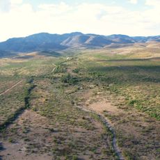
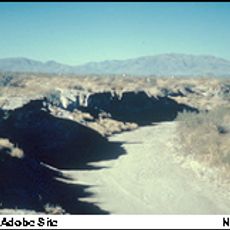
Canyon de Guadalupe, Natural canyon with hot springs in Baja California, Mexico.

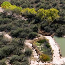
Canyon de Guadalupe is a desert canyon with natural hot springs, palm tree groves, and towering granite rock walls in Baja California. Multiple thermal springs emerge throughout the canyon, flowing between steep slopes and creating pools along the canyon floor.

The canyon served as a vital water source for indigenous peoples since pre-colonial times, making it a key settlement location in the region. Its reliable thermal springs provided the resources needed for early communities to thrive in this harsh desert environment.

Cave paintings and archaeological sites scattered across the rock walls show how early inhabitants lived in this region centuries ago. Walking through the canyon, you can observe these markings and remains that tell the story of the people who made their homes here.

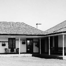
The site requires high-clearance vehicles to navigate the rough terrain and steep access roads into the canyon. Advance reservations are necessary, and visitors should prepare for basic facilities and remote conditions.

Six waterfalls cascade through the canyon, with the thermal springs creating warm pools directly beneath them. This unusual combination of falling water and hot springs is so rare in this dry region that it often surprises first-time visitors.

Location: Baja California

GPS coordinates: 31.46889,-109.03917

Latest update: December 9, 2025 12:22

Photos
Around this place
Show the full map
Skeleton Canyon
United States of America

Skeleton Canyon

13.5 km
Chiricahua Peak
United States of America

Chiricahua Peak

48.3 km
San Bernardino Ranch
United States of America

San Bernardino Ranch

27.2 km
San Bernardino National Wildlife Refuge
United States of America

San Bernardino National Wildlife Refuge

24.9 km
Faraway Ranch Historic District
United States of America

Faraway Ranch Historic District

68.1 km
Leslie Canyon National Wildlife Refuge
United States of America

Leslie Canyon National Wildlife Refuge

46.8 km
Gleeson Jail
United States of America

Gleeson Jail

80.4 km
Big Hatchet Peak
United States of America

Big Hatchet Peak

63.5 km
Bonita Canyon
United States of America

Bonita Canyon

67.1 km
Bisbee Historic District
United States of America

Bisbee Historic District

83.1 km
Rucker Canyon
United States of America

Rucker Canyon

48.7 km
Grand Theatre
United States of America

Grand Theatre

51.3 km
Phelps Dodge General Office Building
United States of America

Phelps Dodge General Office Building

83.2 km
Double Adobe Site
United States of America

Double Adobe Site

48.8 km
Chiricahua National Monument Historic Designed Landscape
United States of America

Chiricahua National Monument Historic Designed Landscape

66.5 km
Plaza Azueta
Mexico

Plaza Azueta

52 km
Portal Ranger Station
United States of America

Portal Ranger Station

49.2 km
Douglas Historic District
United States of America

Douglas Historic District

50.8 km
El Paso and Southwestern Railroad YMCA
United States of America

El Paso and Southwestern Railroad YMCA

51.1 km
United States Post Office and Customs House–Douglas Main
United States of America

United States Post Office and Customs House–Douglas Main

50.7 km
Douglas Residential Historic District
United States of America

Douglas Residential Historic District

50.2 km
Chiricahua Desert Museum
United States of America

Chiricahua Desert Museum

44.7 km
Silver Peak Lookout Complex
United States of America

Silver Peak Lookout Complex

50.9 km
Monte Vista Lookout Cabin
United States of America

Monte Vista Lookout Cabin

47.5 km
Sugarloaf Mountain Lookout
United States of America

Sugarloaf Mountain Lookout

66.5 km
Horseshoe Canyon
United States of America

Horseshoe Canyon

34.9 km
Bonita Canyon Campground
United States of America

Bonita Canyon Campground

67.4 km
Heart of Rocks Loop Trail
United States of America

Heart of Rocks Loop Trail

64.4 km
Show the full map
Reviews

Visited this place? Tap the stars to rate it and share your experience / photos with the community! Try now! You can cancel it anytime.

« Canyon de Guadalupe - Natural canyon with hot springs in Baja California, Mexico » is provided by Around Us (aroundus.com). Images and texts are derived from Wikimedia project under a Creative Commons license. You are allowed to copy, distribute, and modify copies of this page, under the conditions set by the license, as long as this note is clearly visible.

Discover hidden gems everywhere you go!

From secret cafés to breathtaking viewpoints, skip the crowded tourist spots and find places that match your style. Our app makes it easy with voice search, smart filtering, route optimization, and insider tips from travelers worldwide. Download now for the complete mobile experience.

Around Us App Screenshot

A unique approach to discovering new places

Le Figaro

All the places worth exploring

France Info

A tailor-made excursion in just a few clicks

20 Minutes