Coffre ${chestReward.rarityLabel}
+${chestReward.xp} XP
Explorer
NOUVEAU ×${chestReward.collectible.quantity}
tapez pour fermer
Chest locked

Open chests in the app

Around Us is built for your phone — chests unlock when you walk, explore and capture nearby places.

Enable Location

We need your location to show you interesting places around you

Discover nearby places

Find interesting locations and hidden gems around you

Precise directions

Get accurate directions and distances to places

Your location is never shared with other users. It's only used when you tap the location button.

Log in to your account

Start exploring — it's free

Trusted by 72,067 travelers worldwide

Continue with Google
Continue with Apple
or

We will send you a code to connect

By continuing, you accept our Terms and Conditions and our Privacy Policy

Check your inbox

We've sent a pincode in your inbox. Please enter the code below.

Aravaipa Canyon Wilderness
Discussion Reviews Photo
7.4k Popularity

Aravaipa Canyon Wilderness, Protected wilderness area in Graham and Pinal Counties, Arizona

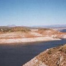
Aravaipa Canyon Wilderness is a protected natural area covering about 19,400 acres in southeastern Arizona, with a permanent stream running through an 11-mile canyon surrounded by tablelands and cliff walls. The canyon remains relatively undeveloped, allowing visitors to experience an intact desert landscape.

The area received wilderness protection status in 1984 through the Bureau of Land Management to preserve its natural condition and ecosystem. This designation established legal protections that limit human impact and development within the canyon system.

Native plants and animals thrive in this protected environment, where visitors can observe natural behaviors without modern infrastructural interference.

Visitors need a permit limited to 50 people daily, with reservations available 13 weeks in advance through the Bureau of Land Management. The hike through the canyon involves navigating rocky terrain and crossing the stream multiple times, so sturdy footwear and water resistance are essential.

Year-round water flow supports large sycamore, ash, cottonwood, and willow trees that create a forest-like environment in the middle of the desert. This permanent stream makes it possible for wildlife that typically requires riparian conditions to thrive far from other river systems.

The community of curious travelers

AroundUs brings together thousands of curated places, local tips, and hidden gems, enriched daily by 60,000 contributors worldwide.

Start exploring
Location
Location
GPS coordinates
32.89700,-110.48800
Latest update
December 8, 2025 20:02
Around this place
Biosphere 2
United States of America

Biosphere 2

49.1 km
Large Binocular Telescope
United States of America

Large Binocular Telescope

60.1 km
Vatican Advanced Technology Telescope
United States of America

Vatican Advanced Technology Telescope

59.9 km
Mount Graham
United States of America

Mount Graham

61.7 km
Mount Graham International Observatory
United States of America

Mount Graham International Observatory

59.9 km
Sierra Bonita Ranch
United States of America

Sierra Bonita Ranch

60.1 km
Mount Lemmon Observatory
United States of America

Mount Lemmon Observatory

58 km
Peppersauce Cave
United States of America

Peppersauce Cave

46.3 km
San Carlos Lake
United States of America

San Carlos Lake

34.3 km
Heinrich Hertz Submillimeter Telescope
United States of America

Heinrich Hertz Submillimeter Telescope

59.9 km
Camp Grant
United States of America

Camp Grant

21.7 km
Oracle State Park
United States of America

Oracle State Park

35.1 km
Besh-Ba-Gowah
United States of America

Besh-Ba-Gowah

60.1 km
Galiuro Wilderness
United States of America

Galiuro Wilderness

37.6 km
Acadia Ranch
United States of America

Acadia Ranch

41.2 km
Globe Downtown Historic District
United States of America

Globe Downtown Historic District

61.9 km
Catalina Station
United States of America

Catalina Station

58.2 km
La Casa del High Jinks
United States of America

La Casa del High Jinks

43.2 km
Gila Valley Bank and Trust Building
United States of America

Gila Valley Bank and Trust Building

61.7 km
Elks Building
United States of America

Elks Building

61.8 km
Winkelman Bridge
United States of America

Winkelman Bridge

28.3 km
Globe Ranger Station
United States of America

Globe Ranger Station

59.6 km
United States Post Office and Courthouse–Globe Main
United States of America

United States Post Office and Courthouse–Globe Main

61.2 km
Columbine Work Station
United States of America

Columbine Work Station

58 km
Besh-Ba-Gowah Museum
United States of America

Besh-Ba-Gowah Museum

60.2 km
Lemmon Rock Lookout House
United States of America

Lemmon Rock Lookout House

58.7 km
SaddleBrooke One
United States of America

SaddleBrooke One

54.4 km
Coolidge Dam
United States of America

Coolidge Dam

31.1 km
Show the full map
Reviews
Share your experience

No review yet

Discussions
Start a discussion...

No discussion yet

« Aravaipa Canyon Wilderness - Protected wilderness area in Graham and Pinal Counties, Arizona » is provided by Around Us (aroundus.com). Images and texts are derived from Wikimedia project under a Creative Commons license. You are allowed to copy, distribute, and modify copies of this page, under the conditions set by the license, as long as this note is clearly visible.

Discover hidden gems everywhere you go!

From secret cafés to breathtaking viewpoints, skip the crowded tourist spots and find places that match your style. Our app makes it easy with voice search, smart filtering, route optimization, and insider tips from travelers worldwide. Download now for the complete mobile experience.

Around Us App Screenshot

A unique approach to discovering new places

Le Figaro

All the places worth exploring

France Info

A tailor-made excursion in just a few clicks

20 Minutes

Around Us
Travel Guide & Maps
Download

Send to your phone

QR Code
1

Open the camera app on your mobile.

2

Point at the QR code with your camera. A notification will appear.

3

Tap the notification to open the link.