Enable Location

We need your location to show you interesting places around you

Discover nearby places

Find interesting locations and hidden gems around you

Precise directions

Get accurate directions and distances to places

Your location is never shared with other users. It's only used when you tap the location button.

Zacatal Bridge

Log in to your account

Start exploring — it's free

Trusted by 62,127 travelers worldwide

Continue with Google
Continue with Apple
or

We will send you a code to connect

By continuing, you accept our Terms and Conditions and our Privacy Policy

Check your inbox

We've sent a pincode in your inbox. Please enter the code below.

Zacatal Bridge

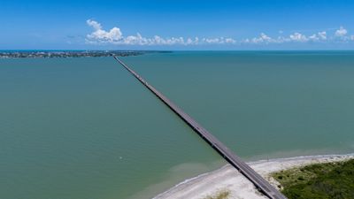
Zacatal Bridge, Highway bridge in Ciudad del Carmen, Mexico.

The Zacatal Bridge is a highway bridge in Ciudad del Carmen that spans over 3,800 meters of water. It connects the Atasta Peninsula to Carmen Island via Federal Highway 180 and provides two lanes for vehicle traffic crossing the gap.

The bridge was completed in 1994 and represented a major turning point for transportation in the Yucatan Peninsula region. Its opening for the first time created a direct road link between two coastal areas that had previously been connected only by water routes.

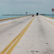
The bridge connects two communities that were once separated by water, reshaping how local people travel and trade between island and mainland. Today it forms part of daily routines for fishermen, merchants, and residents crossing between Carmen Island and the peninsula.

The bridge is passable for all types of vehicles and provides a clear route across the lagoon. Travelers should expect standard driving conditions and can take in views of the surrounding waters while crossing.

The construction used prefabricated concrete sections and modern post-tensioned techniques, making it an ambitious engineering feat for the coastal region. This approach allowed builders to create a stable crossing over shifting water conditions.

The community of curious travelers

AroundUs brings together thousands of curated places, local tips, and hidden gems, enriched daily by 60,000 contributors worldwide.

Start exploring
Official opening
November 24, 1994
Length
3,861 m
GPS coordinates
18.62100,-91.84100
Latest update
December 8, 2025 13:41
« Zacatal Bridge - Highway bridge in Ciudad del Carmen, Mexico » is provided by Around Us (aroundus.com). Images and texts are derived from Wikimedia project under a Creative Commons license. You are allowed to copy, distribute, and modify copies of this page, under the conditions set by the license, as long as this note is clearly visible.

Discover hidden gems everywhere you go!

From secret cafés to breathtaking viewpoints, skip the crowded tourist spots and find places that match your style. Our app makes it easy with voice search, smart filtering, route optimization, and insider tips from travelers worldwide. Download now for the complete mobile experience.

Around Us App Screenshot

A unique approach to discovering new places

Le Figaro

All the places worth exploring

France Info

A tailor-made excursion in just a few clicks

20 Minutes

Around Us
Travel Guide & Maps
Download

Send to your phone

QR Code
1

Open the camera app on your mobile.

2

Point at the QR code with your camera. A notification will appear.

3

Tap the notification to open the link.