Chest opened
+${chestReward.xp} XP
Explorer
NOUVEAU ×${chestReward.collectible.quantity}
tapez pour fermer
Chest locked

Open chests in the app

Around Us is built for your phone — chests unlock when you walk, explore and capture nearby places.

Enable Location

We need your location to show you interesting places around you

Discover nearby places

Find interesting locations and hidden gems around you

Precise directions

Get accurate directions and distances to places

Your location is never shared with other users. It's only used when you tap the location button.

Log in to your account

Start exploring — it's free

Trusted by 72,889 travelers worldwide

Continue with Google
Continue with Apple
or

We will send you a code to connect

By continuing, you accept our Terms and Conditions and our Privacy Policy

Check your inbox

We've sent a pincode in your inbox. Please enter the code below.

Devils River
Discussion Reviews Photo
20.5k Popularity

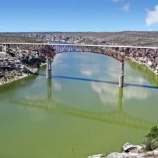
Devils River, Spring-fed river in Southwest Texas, United States

Devils River is a spring-fed waterway in Southwest Texas that flows through limestone canyons with clear water throughout the year. The river cuts through remote terrain where underground sources keep the flow steady.

Native peoples made their homes along this waterway and left rock art that can still be seen today. These marks show how important the location was to early inhabitants of the region.

The river holds meaning for local communities and visitors drawn to its wild character and natural springs. Its conservation reflects how people today value protecting such remote waterways from development.

The location is remote and requires careful planning before visiting due to limited access points. Visitors should expect long approaches and bring everything needed to be self-sufficient for several days.

The water disappears underground through limestone formations and resurfaces miles away as it travels through the rock. This hidden passage naturally filters the water before it emerges again above ground.

The community of curious travelers

AroundUs brings together thousands of curated places, local tips, and hidden gems, enriched daily by 60,000 contributors worldwide.

Start exploring
Location
GPS coordinates
29.45920,-101.05900
Latest update
December 7, 2025 10:05
Around this place
Garner State Park
United States of America

Garner State Park

128.6 km
Amistad Reservoir
United States of America

Amistad Reservoir

1 km
Fort Clark
United States of America

Fort Clark

64.3 km
Sleeping Spring Draw
United States of America

Sleeping Spring Draw

93.1 km
Pecos River High Bridge
United States of America

Pecos River High Bridge

44.1 km
Seminole Canyon State Park and Historic Site
United States of America

Seminole Canyon State Park and Historic Site

35.4 km
Amistad National Recreation Area
United States of America

Amistad National Recreation Area

2.7 km
Fort Duncan
United States of America

Fort Duncan

100.1 km
Eagle Pass – Piedras Negras International Bridge
Mexico

Eagle Pass – Piedras Negras International Bridge

99.4 km
John Nance Garner House
United States of America

John Nance Garner House

126 km
Del Río – Ciudad Acuña International Bridge
Mexico

Del Río – Ciudad Acuña International Bridge

19.5 km
Lake Amistad Dam International Crossing
United States of America

Lake Amistad Dam International Crossing

1.1 km
Camino Real International Bridge
United States of America

Camino Real International Bridge

100.2 km
Whitehead Memorial Museum
United States of America

Whitehead Memorial Museum

19.7 km
Mile Canyon
United States of America

Mile Canyon

61.9 km
Grand Opera House
United States of America

Grand Opera House

126.5 km
Mexico

Rio San Rodrigo

74.6 km
Union Pacific International Railroad Bridge
Mexico

Union Pacific International Railroad Bridge

100.3 km
Martyrs of Christ the King Cathedral, Piedras Negras
Mexico

Martyrs of Christ the King Cathedral, Piedras Negras

98.6 km
Edwards County Courthouse and Jail
United States of America

Edwards County Courthouse and Jail

103 km
Pecos River Bridge
United States of America

Pecos River Bridge

39.7 km
Fate Bell Shelter
United States of America

Fate Bell Shelter

36.3 km
State Highway 3 Bridge at the Nueces River
United States of America

State Highway 3 Bridge at the Nueces River

115.8 km
Lower Pecos Canyonlands Archeological District
United States of America

Lower Pecos Canyonlands Archeological District

36.3 km
Uvalde Downtown Historic District
United States of America

Uvalde Downtown Historic District

126.6 km
Seminole Canyon District
United States of America

Seminole Canyon District

36.3 km
St. Philip's Episcopal Church
United States of America

St. Philip's Episcopal Church

126.3 km
Aztec Theatre
United States of America

Aztec Theatre

99.6 km
Show the full map
Reviews
Share your experience

No review yet

Discussions
Start a discussion...

No discussion yet

« Devils River - Spring-fed river in Southwest Texas, United States » is provided by Around Us (aroundus.com). Images and texts are derived from Wikimedia project under a Creative Commons license. You are allowed to copy, distribute, and modify copies of this page, under the conditions set by the license, as long as this note is clearly visible.

Discover hidden gems everywhere you go!

From secret cafés to breathtaking viewpoints, skip the crowded tourist spots and find places that match your style. Our app makes it easy with voice search, smart filtering, route optimization, and insider tips from travelers worldwide. Download now for the complete mobile experience.

Around Us App Screenshot

A unique approach to discovering new places

Le Figaro

All the places worth exploring

France Info

A tailor-made excursion in just a few clicks

20 Minutes

Around Us
Travel Guide & Maps
Download

Send to your phone

QR Code
1

Open the camera app on your mobile.

2

Point at the QR code with your camera. A notification will appear.

3

Tap the notification to open the link.