Chest opened
+${chestReward.xp} XP
Explorer
NOUVEAU ×${chestReward.collectible.quantity}
tapez pour fermer
Chest locked

Open chests in the app

Around Us is built for your phone — chests unlock when you walk, explore and capture nearby places.

Enable Location

We need your location to show you interesting places around you

Discover nearby places

Find interesting locations and hidden gems around you

Precise directions

Get accurate directions and distances to places

Your location is never shared with other users. It's only used when you tap the location button.

Arkansas River

Log in to your account

Start exploring — it's free

Trusted by 72,890 travelers worldwide

Continue with Google
Continue with Apple
or

We will send you a code to connect

By continuing, you accept our Terms and Conditions and our Privacy Policy

Check your inbox

We've sent a pincode in your inbox. Please enter the code below.

Arkansas River
Discussion Reviews 2 Photos
160k Popularity

Arkansas River, Major river system from Colorado to Mississippi River, US

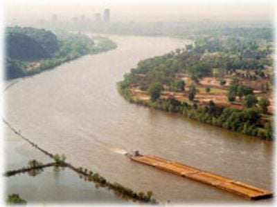
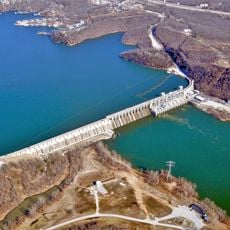
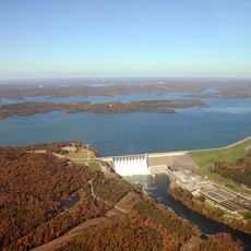
The Arkansas River is a waterway that crosses Colorado, Kansas, Oklahoma and Arkansas before joining the Mississippi. The water flows through shallow banks across the Great Plains region and is controlled by eighteen locks and dams in the lower section.

Francisco Vázquez de Coronado crossed the waterway in 1541 near present-day Dodge City in Kansas. The McClellan-Kerr lock system was built during the twentieth century and allowed navigation far inland.

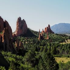
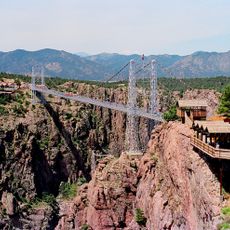
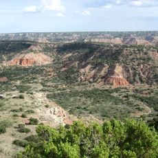
The stone gorge at Royal Gorge was considered sacred by the Ute and Apache for centuries. Today the waterway still separates the Ozark region from the Ouachita hills and shapes the place names of many towns along its course.

The area around the upper section offers opportunities for hiking and kayaking, while the lower stretch is better suited for leisurely boat trips. Access is possible at many points along the banks, but the current can become strong after rainfall.

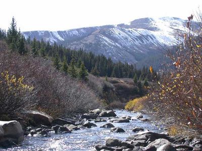
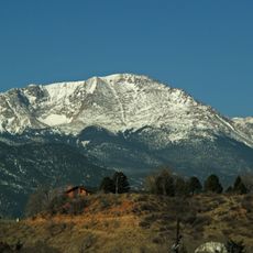
The elevation drops more than 10,000 feet (3,000 m) in the first 125 miles, making the upper section one of the steepest river stretches in North America. The granite walls at Royal Gorge rise in places over 1,000 feet (300 m).

The community of curious travelers

AroundUs brings together thousands of curated places, local tips, and hidden gems, enriched daily by 60,000 contributors worldwide.

Start exploring
Location
Location
Location
Location
GPS coordinates
39.25830,-106.34390
Latest update
December 15, 2025 21:23
Around this place
Lake of the Ozarks
United States of America

Lake of the Ozarks

1196.1 km
Pikes Peak
United States of America

Pikes Peak

121.6 km
Greater Wynnewood Exotic Animal Park
United States of America

Greater Wynnewood Exotic Animal Park

961.6 km
Arrowhead Stadium
United States of America

Arrowhead Stadium

1023.3 km
Los Alamos National Laboratory
United States of America

Los Alamos National Laboratory

376.6 km
Garden of the Gods
United States of America

Garden of the Gods

134.2 km
Loretto Chapel
United States of America

Loretto Chapel

399.3 km
Newby-McMahon Building
United States of America

Newby-McMahon Building

919.5 km
Manitou Incline
United States of America

Manitou Incline

130 km
Cadillac Ranch
United States of America

Cadillac Ranch

595.3 km
Royal Gorge Bridge
United States of America

Royal Gorge Bridge

125.2 km
Fort Sill
United States of America

Fort Sill

861.1 km
Meow Wolf
United States of America

Meow Wolf

402.3 km
Great Sand Dunes National Park and Preserve
United States of America

Great Sand Dunes National Park and Preserve

184.6 km
Crater of Diamonds State Park
United States of America

Crater of Diamonds State Park

1271 km
Kauffman Stadium
United States of America

Kauffman Stadium

1023.6 km
Waggoner Ranch
United States of America

Waggoner Ranch

886.4 km
Palo Duro Canyon
United States of America

Palo Duro Canyon

634.2 km
Table Rock Lake
United States of America

Table Rock Lake

1182.9 km
Silver Dollar City
United States of America

Silver Dollar City

1176.1 km
Little Rock Central High School
United States of America

Little Rock Central High School

1344.5 km
Oklahoma City National Memorial
United States of America

Oklahoma City National Memorial

886.8 km
Hot Springs National Park
United States of America

Hot Springs National Park

1294.1 km
Professional Wrestling Hall of Fame and Museum
United States of America

Professional Wrestling Hall of Fame and Museum

919.5 km
Bishop Castle
United States of America

Bishop Castle

171.9 km
Lake Texoma
United States of America

Lake Texoma

1061.4 km
Gaylord Family Oklahoma Memorial Stadium
United States of America

Gaylord Family Oklahoma Memorial Stadium

908.2 km
Worlds of Fun
United States of America

Worlds of Fun

1021.7 km
Show the full map
Reviews
Share your experience

No review yet

Discussions
Start a discussion...

No discussion yet

« Arkansas River - Major river system from Colorado to Mississippi River, US » is provided by Around Us (aroundus.com). Images and texts are derived from Wikimedia project under a Creative Commons license. You are allowed to copy, distribute, and modify copies of this page, under the conditions set by the license, as long as this note is clearly visible.

Discover hidden gems everywhere you go!

From secret cafés to breathtaking viewpoints, skip the crowded tourist spots and find places that match your style. Our app makes it easy with voice search, smart filtering, route optimization, and insider tips from travelers worldwide. Download now for the complete mobile experience.

Around Us App Screenshot

A unique approach to discovering new places

Le Figaro

All the places worth exploring

France Info

A tailor-made excursion in just a few clicks

20 Minutes

Around Us
Travel Guide & Maps
Download

Send to your phone

QR Code
1

Open the camera app on your mobile.

2

Point at the QR code with your camera. A notification will appear.

3

Tap the notification to open the link.