·

Enable Location

We need your location to show you interesting places around you

Discover nearby places

Find interesting locations and hidden gems around you

Precise directions

Get accurate directions and distances to places

Your location is never shared with other users. It's only used when you tap the location button.

Harrietta Plantation

Log in to your account

Start exploring — it's free

Trusted by 62,653 travelers worldwide

Continue with Google
Continue with Apple
or

We will send you a code to connect

By continuing, you accept our Terms and Conditions and our Privacy Policy

Check your inbox

We've sent a pincode in your inbox. Please enter the code below.

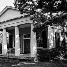
Harrietta Plantation, human settlement in South Carolina, United States of America

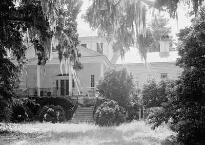
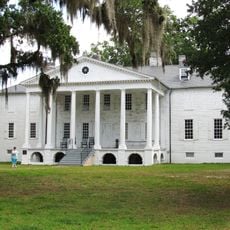
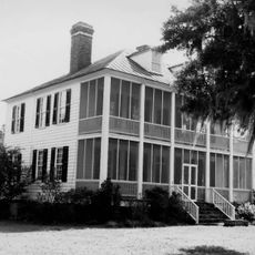
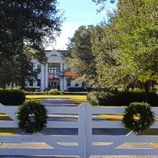
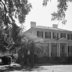
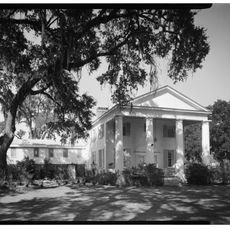
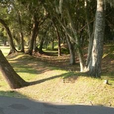
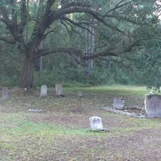
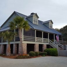
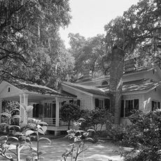
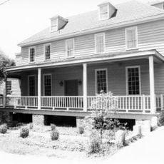
Harrietta Plantation is a historic house in South Carolina built around 1807 in Georgian style with a raised basement and columned porch. The structure features two main rooms on the ground floor with side wings added later, formal gardens extending to Collins Creek, and remnants of a rice mill and slave cabin on the property.

Built around 1807 by Mrs. Harriot Horry for her daughter Harriott and son-in-law Frederick Rutledge, the house was expanded in the 1930s with Greek Revival wings. Rice farming continued on the estate until the early 1900s, and the property was listed on the National Register of Historic Places in 1975.

The name honors Harriott Rutledge, daughter of the original builder. The estate reflects how wealthy planters in coastal South Carolina lived, with formal gardens and architectural choices that revealed their status and shaped daily routines around the main house.

The property sits about 5 miles east of McClellanville and is accessible by local roads. The raised basement design provides natural protection from the wet climate and flooding that once threatened the region during heavy rains.

The house includes a false door between the two main rooms on its front facade that was added purely for symmetrical appearance and never functioned as an actual entrance. This architectural trick was a fashionable detail of Georgian design meant to create visual balance on the building's face.

The community of curious travelers

AroundUs brings together thousands of curated places, local tips, and hidden gems, enriched daily by 60,000 contributors worldwide.

Start exploring
Location
GPS coordinates
33.16944,-79.39361
Latest update
February 9, 2026 08:23
Around this place
Hampton Plantation
United States of America

Hampton Plantation

5.2 km
Cape Romain National Wildlife Refuge
United States of America

Cape Romain National Wildlife Refuge

25.3 km
Hopsewee
United States of America

Hopsewee

4.7 km
Hell Hole Swamp
United States of America

Hell Hole Swamp

29.6 km
Arcadia Plantation
United States of America

Arcadia Plantation

28.6 km
Black River Plantation House
United States of America

Black River Plantation House

38.9 km
Beneventum Plantation House
United States of America

Beneventum Plantation House

33.1 km
Annandale Plantation
United States of America

Annandale Plantation

10 km
Battery White
United States of America

Battery White

17.6 km
All Saints' Episcopal Church, Waccamaw
United States of America

All Saints' Episcopal Church, Waccamaw

40.7 km
Georgetown Light
United States of America

Georgetown Light

20.3 km
Pee Dee River Rice Planters Historic District
United States of America

Pee Dee River Rice Planters Historic District

6.8 km
Temple Beth Elohim
United States of America

Temple Beth Elohim

24.5 km
Bethel African Methodist Episcopal Church
United States of America

Bethel African Methodist Episcopal Church

10.7 km
Pawleys Island Historic District
United States of America

Pawleys Island Historic District

37.4 km
Wicklow Hall Plantation
United States of America

Wicklow Hall Plantation

8.8 km
Georgetown Historic District
United States of America

Georgetown Historic District

24.3 km
Joseph H. Rainey House
United States of America

Joseph H. Rainey House

24.4 km
Sewee Mound
United States of America

Sewee Mound

27.9 km
Winyah Indigo School
United States of America

Winyah Indigo School

24.7 km
Bull Island
United States of America

Bull Island

35.4 km
Cape Romain Lighthouse
United States of America

Cape Romain Lighthouse

16.9 km
Kaminski House Museum
United States of America

Kaminski House Museum

24.3 km
Old Cape Romain Lighthouse
United States of America

Old Cape Romain Lighthouse

16.9 km
St. Mary's Church
United States of America

St. Mary's Church

24.6 km
Sewee Visitor and Environmental Education Center
United States of America

Sewee Visitor and Environmental Education Center

33.6 km
Winyah Indigo Society Hall
United States of America

Winyah Indigo Society Hall

24.2 km
Georgetown County Courthouse
United States of America

Georgetown County Courthouse

24.3 km
Show the full map
« Harrietta Plantation - human settlement in South Carolina, United States of America » is provided by Around Us (aroundus.com). Images and texts are derived from Wikimedia project under a Creative Commons license. You are allowed to copy, distribute, and modify copies of this page, under the conditions set by the license, as long as this note is clearly visible.

Discover hidden gems everywhere you go!

From secret cafés to breathtaking viewpoints, skip the crowded tourist spots and find places that match your style. Our app makes it easy with voice search, smart filtering, route optimization, and insider tips from travelers worldwide. Download now for the complete mobile experience.

Around Us App Screenshot

A unique approach to discovering new places

Le Figaro

All the places worth exploring

France Info

A tailor-made excursion in just a few clicks

20 Minutes

Around Us
Travel Guide & Maps
Download

Send to your phone

QR Code
1

Open the camera app on your mobile.

2

Point at the QR code with your camera. A notification will appear.

3

Tap the notification to open the link.