·

Enable Location

We need your location to show you interesting places around you

Discover nearby places

Find interesting locations and hidden gems around you

Precise directions

Get accurate directions and distances to places

Your location is never shared with other users. It's only used when you tap the location button.

Lake Nacimiento

Log in to your account

Start exploring — it's free

Trusted by 62,646 travelers worldwide

Continue with Google
Continue with Apple
or

We will send you a code to connect

By continuing, you accept our Terms and Conditions and our Privacy Policy

Check your inbox

We've sent a pincode in your inbox. Please enter the code below.

Lake Nacimiento

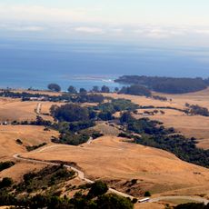
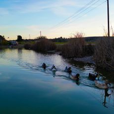
Lake Nacimiento, Reservoir in San Luis Obispo County, California, US

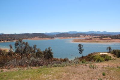
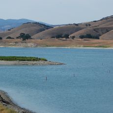
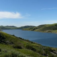
Lake Nacimiento is a reservoir covering roughly 2,000 hectares (5,000 acres) with 265 kilometers (165 miles) of shoreline in the Santa Lucia Mountains of San Luis Obispo County, California. The winding arms and inlets branch between wooded hills and form a sprawling network of narrow waterways.

The Nacimiento Dam was built between 1954 and 1957 to irrigate farmland and control flooding from the Nacimiento River. The completed structure filled the valley and created the current waterscape with its many branches.

Anglers and boat operators know the branching inlets well and follow them according to season and water level. Local names for certain arms and bends reflect the close connection residents have with the artificial body of water.

The docking area offers slip rentals, equipment hire, and a supply shop, while several campgrounds are spread along the shore. Access to individual inlets is often from the water, as many shoreline areas are surrounded by hills.

Some of the water arms stretch for several kilometers between narrow hillsides and recall Norwegian fjords. These slim corridors create sheltered zones that paddlers favor for their calm conditions.

The community of curious travelers

AroundUs brings together thousands of curated places, local tips, and hidden gems, enriched daily by 60,000 contributors worldwide.

Start exploring
Location
GPS coordinates
35.74345,-120.96085
Latest update
December 20, 2025 16:12
Around this place
Hearst Castle
United States of America

Hearst Castle

19.8 km
Nitt Witt Ridge
United States of America

Nitt Witt Ridge

23.1 km
Hearst Ranch
United States of America

Hearst Ranch

19.2 km
Lake San Antonio
United States of America

Lake San Antonio

11.9 km
Hearst San Simeon State Park
United States of America

Hearst San Simeon State Park

23 km
Piedras Blancas Light Station
United States of America

Piedras Blancas Light Station

30.5 km
William Randolph Hearst Memorial State Beach
United States of America

William Randolph Hearst Memorial State Beach

23.4 km
Cayucos State Beach
United States of America

Cayucos State Beach

33.2 km
Salmon Creek Falls
United States of America

Salmon Creek Falls

36.3 km
Silver Peak Wilderness
United States of America

Silver Peak Wilderness

32.2 km
Whale Rock Reservoir
United States of America

Whale Rock Reservoir

32.7 km
Harmony Headlands State Park
United States of America

Harmony Headlands State Park

29.7 km
Carlton Hotel
United States of America

Carlton Hotel

38.6 km
Rios-Caledonia Adobe
United States of America

Rios-Caledonia Adobe

23.7 km
Estero Bluffs State Park
United States of America

Estero Bluffs State Park

33 km
Kenneth S. Norris Rancho Marino Reserve
United States of America

Kenneth S. Norris Rancho Marino Reserve

26.2 km
Sebastian Store
United States of America

Sebastian Store

23.6 km
Estrella Adobe Church
United States of America

Estrella Adobe Church

29.8 km
Paso Robles Carnegie Library
United States of America

Paso Robles Carnegie Library

27.9 km
Bank of Italy
United States of America

Bank of Italy

27.7 km
William Randolph Hearst Memorial Beach
United States of America

William Randolph Hearst Memorial Beach

23.6 km
Franklin Hot Springs
United States of America

Franklin Hot Springs

33.6 km
Sculpterra Winery and Sculpture Garden
United States of America

Sculpterra Winery and Sculpture Garden

35.4 km
Fort Hunter Liggett
United States of America

Fort Hunter Liggett

33.7 km
Cayucos Beach
United States of America

Cayucos Beach

33.2 km
Call-Booth House
United States of America

Call-Booth House

27.1 km
Cayucos State Beach
United States of America

Cayucos State Beach

33.4 km
Camp Roberts Historical Museum
United States of America

Camp Roberts Historical Museum

19.9 km
Show the full map
« Lake Nacimiento - Reservoir in San Luis Obispo County, California, US » is provided by Around Us (aroundus.com). Images and texts are derived from Wikimedia project under a Creative Commons license. You are allowed to copy, distribute, and modify copies of this page, under the conditions set by the license, as long as this note is clearly visible.

Discover hidden gems everywhere you go!

From secret cafés to breathtaking viewpoints, skip the crowded tourist spots and find places that match your style. Our app makes it easy with voice search, smart filtering, route optimization, and insider tips from travelers worldwide. Download now for the complete mobile experience.

Around Us App Screenshot

A unique approach to discovering new places

Le Figaro

All the places worth exploring

France Info

A tailor-made excursion in just a few clicks

20 Minutes

Around Us
Travel Guide & Maps
Download

Send to your phone

QR Code
1

Open the camera app on your mobile.

2

Point at the QR code with your camera. A notification will appear.

3

Tap the notification to open the link.