Trinity Dam

Log in to your account

AroundUs is a community-driven map of interesting places, built by curious explorers like you. It grows with every review, story, and photo you share.
Connect to save your favorite spots, contribute locations, and create personalized routes.
By continuing, you accept our Terms and Conditions and our Privacy Policy
Add to collection
Map
Suggest a change
Share

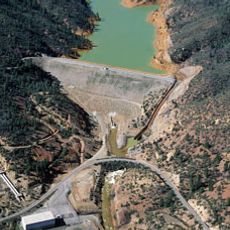
Trinity Dam, Embankment dam and hydroelectric station in Trinity County, United States

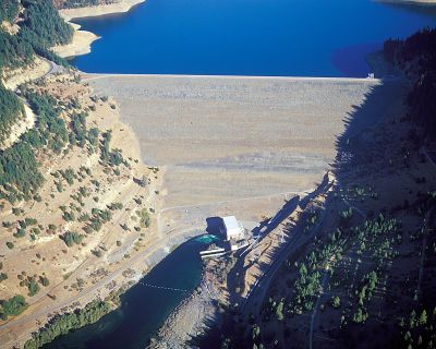
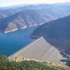
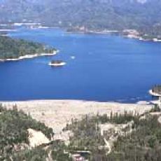
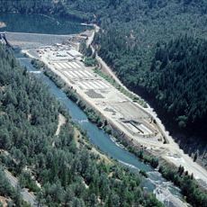
Trinity Dam is an embankment dam on the Trinity River in California, rising 164 meters high and forming Trinity Lake, the state's third largest reservoir with around 233 kilometers of shoreline. The facility uses two Francis turbines to generate power while regulating water flow for irrigation and flood control.

The United States Congress authorized the Central Valley Project in 1935, which eventually led to Trinity Dam's construction beginning in 1956 and completion in 1957. The project was part of a broader infrastructure effort to manage water resources and generate power across the western United States.

The reservoir's name reflects local preferences after residents' homes were submerged during construction. The change from Clair Engle Lake to Trinity Lake shows how the community's identity became tied to this new landscape.

The reservoir is accessible during daylight hours, with various areas offering different opportunities for sightseeing and recreation. It is wise to dress appropriately for the weather and bring water and suitable gear, as conditions vary with the season.

The facility has a morning glory spillway that handles about 630 cubic meters of water per second and is known for its distinctive design. An auxiliary spillway can discharge an additional 64 cubic meters per second and works together with the main system for flood safety.

Location: Trinity County

Inception: 1957

Length: 747 m

GPS coordinates: 40.80110,-122.76300

Latest update: December 10, 2025 15:51

Photos
Around this place
Shasta Lake
United States of America

Shasta Lake

33.3 km
Sundial Bridge at Turtle Bay
United States of America

Sundial Bridge at Turtle Bay

39.9 km
Castle Crags
United States of America

Castle Crags

54.8 km
Trinity Lake
United States of America

Trinity Lake

2.4 km
Whiskeytown Lake
United States of America

Whiskeytown Lake

29.2 km
Lake Shasta Caverns
United States of America

Lake Shasta Caverns

38.6 km
Trinity Alps Wilderness
United States of America

Trinity Alps Wilderness

36.3 km
Saint Herman of Alaska Brotherhood
United States of America

Saint Herman of Alaska Brotherhood

51.9 km
Pit River Bridge
United States of America

Pit River Bridge

37.7 km
Turtle Bay Exploration Park
United States of America

Turtle Bay Exploration Park

40.4 km
Castle Crags Wilderness
United States of America

Castle Crags Wilderness

54.2 km
Keswick Dam
United States of America

Keswick Dam

34 km
Whiskeytown Dam
United States of America

Whiskeytown Dam

29.2 km
Thompson Peak
United States of America

Thompson Peak

32.7 km
Spring Creek Dam
United States of America

Spring Creek Dam

31 km
Cascade Theatre
United States of America

Cascade Theatre

39.9 km
Lewiston Lake
United States of America

Lewiston Lake

8.7 km
Lewiston Dam
United States of America

Lewiston Dam

8.9 km
Castle Crags State Park
United States of America

Castle Crags State Park

53.8 km
Spring Creek Reservoir
United States of America

Spring Creek Reservoir

31 km
McConnell Arboretum & Botanical Gardens
United States of America

McConnell Arboretum & Botanical Gardens

39.6 km
Bowerman Barn
United States of America

Bowerman Barn

11 km
Edward Frisbie House
United States of America

Edward Frisbie House

39.6 km
French Gulch Historic District
United States of America

French Gulch Historic District

14.9 km
Weaverville Joss House State Historic Park
United States of America

Weaverville Joss House State Historic Park

16.8 km
Fantasy Fountain
United States of America

Fantasy Fountain

45.6 km
Lower Pollard Flat Bridge
United States of America

Lower Pollard Flat Bridge

36.2 km
UP Sacramento River Bridge
United States of America

UP Sacramento River Bridge

46.8 km
Show the full map
Reviews

Visited this place? Tap the stars to rate it and share your experience / photos with the community! Try now! You can cancel it anytime.

« Trinity Dam - Embankment dam and hydroelectric station in Trinity County, United States » is provided by Around Us (aroundus.com). Images and texts are derived from Wikimedia project under a Creative Commons license. You are allowed to copy, distribute, and modify copies of this page, under the conditions set by the license, as long as this note is clearly visible.

Discover hidden gems everywhere you go!

From secret cafés to breathtaking viewpoints, skip the crowded tourist spots and find places that match your style. Our app makes it easy with voice search, smart filtering, route optimization, and insider tips from travelers worldwide. Download now for the complete mobile experience.

Around Us App Screenshot

A unique approach to discovering new places

Le Figaro

All the places worth exploring

France Info

A tailor-made excursion in just a few clicks

20 Minutes