Enable Location

We need your location to show you interesting places around you

Discover nearby places

Find interesting locations and hidden gems around you

Precise directions

Get accurate directions and distances to places

Your location is never shared with other users. It's only used when you tap the location button.

Whitney Glacier

Log in to your account

Start exploring — it's free

Trusted by 65,040 travelers worldwide

Continue with Google
Continue with Apple
or

We will send you a code to connect

By continuing, you accept our Terms and Conditions and our Privacy Policy

Check your inbox

We've sent a pincode in your inbox. Please enter the code below.

Whitney Glacier
Discussion Reviews 1 Photos
5.3k Popularity

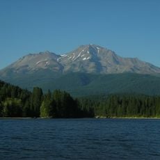
Whitney Glacier, Glacier on Mount Shasta, California

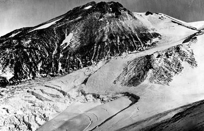
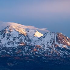
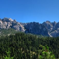
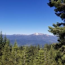
Whitney Glacier is an active glacier on the north face of Mount Shasta in northern California. It begins near the summit and runs down a long slope, forming deep crevasses and distinct ice walls along its path.

The glacier was first officially documented by American scientists in the late 19th century. Since then, researchers have tracked its extent and found that it has pulled back considerably over the course of the 20th century.

Whitney Glacier takes its name from Josiah Whitney, a geologist who surveyed California in the 19th century. His name ties the place to the early history of scientific exploration in the American West.

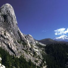
The glacier is only reachable by experienced mountaineers who are comfortable traveling on ice and carry the right gear. Weather on the mountain can shift fast, so thorough preparation before heading up is essential.

Whitney Glacier is considered the longest glacier in California. Because it sits on an active volcano, heat from below affects how the ice moves and melts at its base, which sets it apart from most glaciers in the country.

The community of curious travelers

AroundUs brings together thousands of curated places, local tips, and hidden gems, enriched daily by 60,000 contributors worldwide.

Start exploring
Location
GPS coordinates
41.41389,-122.21139
Latest update
March 3, 2026 10:08
Around this place
Mount Shasta
United States of America

Mount Shasta

1.5 km
Wyntoon
United States of America

Wyntoon

27.8 km
Medicine Lake Volcano
United States of America

Medicine Lake Volcano

54.4 km
Mossbrae Falls
United States of America

Mossbrae Falls

19.7 km
Castle Crags
United States of America

Castle Crags

28.6 km
Black Butte
United States of America

Black Butte

12.6 km
Shastina
United States of America

Shastina

1.1 km
Lake Siskiyou
United States of America

Lake Siskiyou

18 km
Mount Eddy
United States of America

Mount Eddy

24.7 km
Mount Shasta Wilderness
United States of America

Mount Shasta Wilderness

667 m
Castle Crags Wilderness
United States of America

Castle Crags Wilderness

28.3 km
Shasta Abbey
United States of America

Shasta Abbey

13.8 km
Hedge Creek Falls
United States of America

Hedge Creek Falls

20.2 km
Mount Shasta City Park
United States of America

Mount Shasta City Park

13.5 km
Box Canyon Dam
United States of America

Box Canyon Dam

17.9 km
Rainbow Mountain
United States of America

Rainbow Mountain

22.3 km
Dunsmuir Botanical Gardens
United States of America

Dunsmuir Botanical Gardens

30.8 km
Castle Crags State Park
United States of America

Castle Crags State Park

29.5 km
Yreka Carnegie Library
United States of America

Yreka Carnegie Library

50.2 km
Forest House
United States of America

Forest House

49 km
Siskiyou County Museum
United States of America

Siskiyou County Museum

49.5 km
Sierra Club Horse Camp Lodge
United States of America

Sierra Club Horse Camp Lodge

4.9 km
John Everitt Memorial Vista Point
United States of America

John Everitt Memorial Vista Point

9.4 km
McCloud Falls (Lower, Middle, Upper)
United States of America

McCloud Falls (Lower, Middle, Upper)

25.4 km
West Miner Street-Third Street Historic District
United States of America

West Miner Street-Third Street Historic District

50 km
Lower Pollard Flat Bridge
United States of America

Lower Pollard Flat Bridge

50 km
UP Sacramento River Bridge
United States of America

UP Sacramento River Bridge

19.6 km
UP Sacramento River Bridge
United States of America

UP Sacramento River Bridge

38.6 km
Show the full map
Reviews
Share your experience

No review yet

Discussions
Start a discussion...

No discussion yet

« Whitney Glacier - Glacier on Mount Shasta, California » is provided by Around Us (aroundus.com). Images and texts are derived from Wikimedia project under a Creative Commons license. You are allowed to copy, distribute, and modify copies of this page, under the conditions set by the license, as long as this note is clearly visible.

Discover hidden gems everywhere you go!

From secret cafés to breathtaking viewpoints, skip the crowded tourist spots and find places that match your style. Our app makes it easy with voice search, smart filtering, route optimization, and insider tips from travelers worldwide. Download now for the complete mobile experience.

Around Us App Screenshot

A unique approach to discovering new places

Le Figaro

All the places worth exploring

France Info

A tailor-made excursion in just a few clicks

20 Minutes

Around Us
Travel Guide & Maps
Download

Send to your phone

QR Code
1

Open the camera app on your mobile.

2

Point at the QR code with your camera. A notification will appear.

3

Tap the notification to open the link.