Chest opened
+${chestReward.xp} XP
Explorer
NOUVEAU ×${chestReward.collectible.quantity}
tapez pour fermer
Chest locked

Open chests in the app

Around Us is built for your phone — chests unlock when you walk, explore and capture nearby places.

Enable Location

We need your location to show you interesting places around you

Discover nearby places

Find interesting locations and hidden gems around you

Precise directions

Get accurate directions and distances to places

Your location is never shared with other users. It's only used when you tap the location button.

Sierra Madre Mountains

Log in to your account

Start exploring — it's free

Trusted by 72,984 travelers worldwide

Continue with Google
Continue with Apple
or

We will send you a code to connect

By continuing, you accept our Terms and Conditions and our Privacy Policy

Check your inbox

We've sent a pincode in your inbox. Please enter the code below.

Sierra Madre Mountains
Discussion Reviews 1 Photos
9.5k Popularity

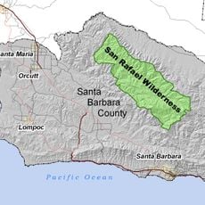
Sierra Madre Mountains, Mountain range in Santa Barbara County, California

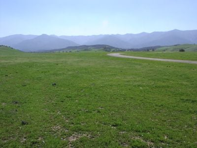
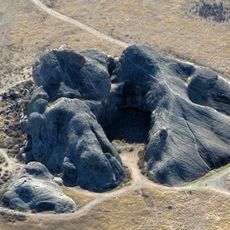
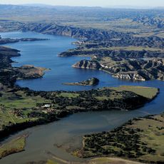
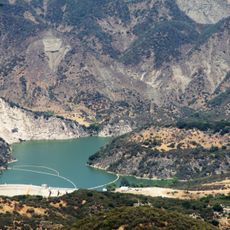
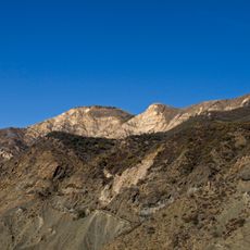
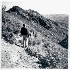
The Sierra Madre Mountains are a mountain range in Santa Barbara County, California, running in a northwest-to-southeast direction. The terrain is steep and rocky, with narrow valleys, exposed ridges, and peaks that reach around 5,843 feet (about 1,780 meters).

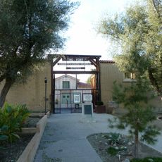
The US Board of Geographic Names officially recognized this range under the name Sierra Madre in 1965, setting it apart from nearby ranges with similar features. Before that formal recognition, the area was known primarily through Chumash traditions and later through Spanish colonial settlement.

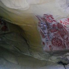
The Chumash people left rock paintings at sites like Painted Rock, which they called S'ap'aski in their language, and these places are still visible today. Walking near these sites gives visitors a sense of how this land was used for ceremonies long before European arrival.

Access to the mountain crest follows a narrow dirt road that often requires a high-clearance vehicle and can close after storms. Checking road conditions before heading out is a good idea, as weather in this area can change quickly and limit access for days at a time.

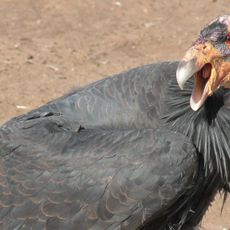
This range is one of the few places in the US where the California condor can be spotted in the wild after the species came close to disappearing entirely. These birds were part of a recovery program, and seeing one soaring over the ridges is an uncommon sight that few visitors expect.

The community of curious travelers

AroundUs brings together thousands of curated places, local tips, and hidden gems, enriched daily by 60,000 contributors worldwide.

Start exploring
Location
Elevation above the sea
1,783 m
GPS coordinates
34.90220,-119.85875
Latest update
March 3, 2026 10:13
Around this place
Neverland Ranch
United States of America

Neverland Ranch

27.3 km
Rancho del Cielo
United States of America

Rancho del Cielo

45.9 km
Mission Santa Inés
United States of America

Mission Santa Inés

42.6 km
Knapp's Castle
United States of America

Knapp's Castle

42.6 km
Chumash Painted Cave State Historic Park
United States of America

Chumash Painted Cave State Historic Park

44.8 km
Painted Rock
United States of America

Painted Rock

27.2 km
Cold Spring Canyon Arch Bridge
United States of America

Cold Spring Canyon Arch Bridge

41.9 km
Figueroa Mountain
United States of America

Figueroa Mountain

21.1 km
San Rafael Wilderness
United States of America

San Rafael Wilderness

10.1 km
Bitter Creek National Wildlife Refuge
United States of America

Bitter Creek National Wildlife Refuge

45.7 km
OstrichLand USA
United States of America

OstrichLand USA

43.9 km
Twitchell Reservoir
United States of America

Twitchell Reservoir

44.6 km
Lake Cachuma
United States of America

Lake Cachuma

36.9 km
Gibraltar Dam
United States of America

Gibraltar Dam

44.6 km
Solvang Vintage Motorcycle Museum
United States of America

Solvang Vintage Motorcycle Museum

42.6 km
Caliente Mountain
United States of America

Caliente Mountain

17.4 km
The Fort
United States of America

The Fort

45.3 km
Los Alamos Ranch House
United States of America

Los Alamos Ranch House

45.5 km
Chapel of San Ramon
United States of America

Chapel of San Ramon

35.4 km
Little Pine Mountain
United States of America

Little Pine Mountain

35.3 km
Madulce Peak
United States of America

Madulce Peak

33.9 km
Elverhøj Museum of History and Art
United States of America

Elverhøj Museum of History and Art

43.2 km
Fort Preservation Society
United States of America

Fort Preservation Society

45.2 km
Ken Brown Wines
United States of America

Ken Brown Wines

44.5 km
Solvang Park
United States of America

Solvang Park

42.7 km
Solvang Festival Theater
United States of America

Solvang Festival Theater

42.9 km
Zaca Creek Bridge No. 1
United States of America

Zaca Creek Bridge No. 1

40.5 km
Zaca Creek Bridge No. 2
United States of America

Zaca Creek Bridge No. 2

41 km
Show the full map
Reviews
Share your experience

No review yet

Discussions
Start a discussion...

No discussion yet

« Sierra Madre Mountains - Mountain range in Santa Barbara County, California » is provided by Around Us (aroundus.com). Images and texts are derived from Wikimedia project under a Creative Commons license. You are allowed to copy, distribute, and modify copies of this page, under the conditions set by the license, as long as this note is clearly visible.

Discover hidden gems everywhere you go!

From secret cafés to breathtaking viewpoints, skip the crowded tourist spots and find places that match your style. Our app makes it easy with voice search, smart filtering, route optimization, and insider tips from travelers worldwide. Download now for the complete mobile experience.

Around Us App Screenshot

A unique approach to discovering new places

Le Figaro

All the places worth exploring

France Info

A tailor-made excursion in just a few clicks

20 Minutes

Around Us
Travel Guide & Maps
Download

Send to your phone

QR Code
1

Open the camera app on your mobile.

2

Point at the QR code with your camera. A notification will appear.

3

Tap the notification to open the link.