Antelope Valley California Poppy Reserve State Natural Reserve

Log in to your account

AroundUs is a community-driven map of interesting places, built by curious explorers like you. It grows with every review, story, and photo you share.
Connect to save your favorite spots, contribute locations, and create personalized routes.
By continuing, you accept our Terms and Conditions and our Privacy Policy

Antelope Valley California Poppy Reserve State Natural Reserve

Add to collection
Map
Suggest a change
Share

Antelope Valley California Poppy Reserve State Natural Reserve, State natural reserve in Los Angeles County, United States.

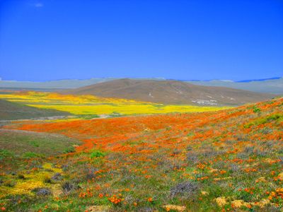
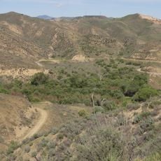
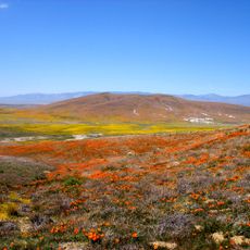
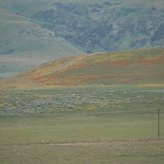
The Antelope Valley California Poppy Reserve State Natural Reserve is a protected area in Los Angeles County that sits on rolling hills of the Mojave Desert between 2600 and 3000 feet (790 and 910 meters) elevation. The landscape consists of gently undulating plains covered with grassland that bursts into bright poppy fields during the blooming season.

The California Department of Parks and Recreation created this protected space in 1976 to safeguard the natural home of the official state flower. The site was chosen because it holds large concentrations of California poppies in their wild form.

The reserve takes its name from the pronghorn antelope that once roamed these plains. Today, visitors gather each spring to photograph the wildflower displays, walking among the brilliant orange carpets that cover the gentle slopes.

The reserve offers 11 kilometers (7 miles) of marked trails in different lengths suitable for different fitness levels. Peak blooms happen from late February through early May, with exact intensity depending on winter rain.

The reserve forbids any artificial watering or flower picking to maintain natural bloom cycles. These rules ensure the poppy fields depend entirely on winter rainfall, sometimes producing sparse displays and other years covering the hills completely.

Location: Los Angeles County

Inception: 1976

Website: http://parks.ca.gov/?page_id=627

GPS coordinates: 34.72750,-118.39500

Latest update: December 5, 2025 22:25

Around this place
Show the full map
Willow Springs International Motorsports Park
United States of America

Willow Springs International Motorsports Park

20.3 km
Pyramid Lake
United States of America

Pyramid Lake

35 km
Castaic Lake
United States of America

Castaic Lake

29.2 km
Shambala Preserve
United States of America

Shambala Preserve

34.6 km
Scaled Composites Triumph
United States of America

Scaled Composites Triumph

31.3 km
Joe Davies Heritage Airpark
United States of America

Joe Davies Heritage Airpark

31.3 km
Soledad Canyon
United States of America

Soledad Canyon

30.5 km
Shea's Castle
United States of America

Shea's Castle

3.3 km
Saugus Speedway
United States of America

Saugus Speedway

36.7 km
Bouquet Reservoir
United States of America

Bouquet Reservoir

16.3 km
Arthur B. Ripley Desert Woodland State Park
United States of America

Arthur B. Ripley Desert Woodland State Park

10.5 km
Castaic Lake State Recreation Area
United States of America

Castaic Lake State Recreation Area

29.3 km
Dry Town Water Park
United States of America

Dry Town Water Park

36.1 km
Double Mountain
United States of America

Double Mountain

35.1 km
Dry Canyon Reservoir
United States of America

Dry Canyon Reservoir

29.7 km
Burnt Peak
United States of America

Burnt Peak

17.4 km
Vista del Lago
United States of America

Vista del Lago

34.3 km
Fairmont Butte
United States of America

Fairmont Butte

2.7 km
Western Hotel
United States of America

Western Hotel

23.6 km
Willow Springs Canyon
United States of America

Willow Springs Canyon

4.2 km
Vaquero Beach
United States of America

Vaquero Beach

34.7 km
Vasquez Rocks
United States of America

Vasquez Rocks

28.5 km
Blackbird Airpark
United States of America

Blackbird Airpark

31.5 km
Moah:cedar
United States of America

Moah:cedar

23.6 km
Elyze Clifford Interpretive Center
United States of America

Elyze Clifford Interpretive Center

19.6 km
Blackbird Airpark
United States of America

Blackbird Airpark

31.5 km
Vasquez Rocks Park
United States of America

Vasquez Rocks Park

28.4 km
Armstrong Aircraft Operations Facility
United States of America

Armstrong Aircraft Operations Facility

31.8 km
Show the full map

Reviews

Visited this place? Tap the stars to rate it and share your experience / photos with the community! Try now! You can cancel it anytime.

« Antelope Valley California Poppy Reserve State Natural Reserve - State natural reserve in Los Angeles County, United States » is provided by Around Us (aroundus.com). Images and texts are derived from Wikimedia project under a Creative Commons license. You are allowed to copy, distribute, and modify copies of this page, under the conditions set by the license, as long as this note is clearly visible.

Discover hidden gems everywhere you go!

From secret cafés to breathtaking viewpoints, skip the crowded tourist spots and find places that match your style. Our app makes it easy with voice search, smart filtering, route optimization, and insider tips from travelers worldwide. Download now for the complete mobile experience.

Around Us App Screenshot

A unique approach to discovering new places

Le Figaro

All the places worth exploring

France Info

A tailor-made excursion in just a few clicks

20 Minutes