Vasquez Rocks

Log in to your account

AroundUs is a community-driven map of interesting places, built by curious explorers like you. It grows with every review, story, and photo you share.
Connect to save your favorite spots, contribute locations, and create personalized routes.
Continue with Google
Continue with Apple
Continue with X
Continue with Facebook
Continue with email
By continuing, you accept our Terms and Conditions and our Privacy Policy
Create an account
Add to collection
Map
Suggest a change
Share

Vasquez Rocks, Natural rock formations in Santa Clarita, United States

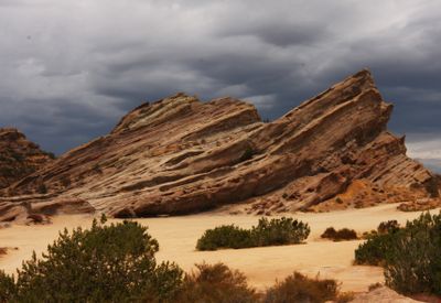
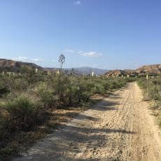
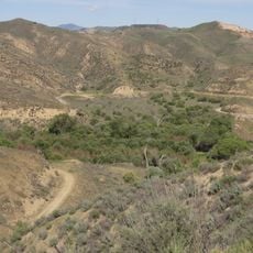
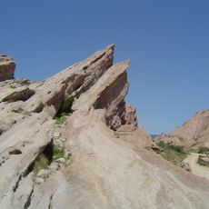
Vasquez Rocks is a 932-acre park with tilted sandstone formations that rise from the ground at steep 45-degree angles and reach heights of up to 150 feet. The rock shapes create an unusual landscape with multiple trails for exploring.

The area was originally home to the Tataviam people, who lived there for thousands of years. In the 1800s, it later became known as a hideout for Mexican outlaw Tiburcio Vasquez, from whom the location took its name.

The distinctive rock shapes have made this a popular filming location for television and movies since the 1930s, with multiple productions using them as a backdrop. You can still see why filmmakers chose this place when you walk through and view the landscape.

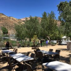
The park is open daily from sunrise to sunset and offers hiking trails, picnic areas, and parking near the main entrance. Bring plenty of water since the area has little shade and the sun can be strong.

The rock formations originated around 25 million years ago through sediment buildup and seismic activity connected to the San Andreas Fault system. These geological processes created one of the region's most distinctive landscapes.

Location: Los Angeles County

Website: http://parks.lacounty.gov/wps/portal/dpr/Parks/Vasquez_Rocks_Natural_Area

GPS coordinates: 34.47990,-118.31700

Latest update: December 6, 2025 17:50

Photos
Colorado natural treasures and remote locations

Colorado contains natural areas and historical sites located away from main roads and common routes. These places tell the story of the state's geology and human history through varied landscapes. Visitors will find sand dunes, waterfalls, rock formations, and remains from the mining era. Locations...

Around this place
Golden Oak Ranch
United States of America

Golden Oak Ranch

18.9 km
California State Route 14
United States of America

California State Route 14

17.4 km
Nethercutt Collection
United States of America

Nethercutt Collection

23.5 km
Shambala Preserve
United States of America

Shambala Preserve

7.4 km
Scaled Composites Triumph
United States of America

Scaled Composites Triumph

25 km
Mount Lukens, California
United States of America

Mount Lukens, California

24.5 km
San Francisquito Canyon
United States of America

San Francisquito Canyon

24.4 km
Joe Davies Heritage Airpark
United States of America

Joe Davies Heritage Airpark

25 km
Placerita Canyon State Park
United States of America

Placerita Canyon State Park

16.6 km
Soledad Canyon
United States of America

Soledad Canyon

21.5 km
Shea's Castle
United States of America

Shea's Castle

25.2 km
Bouquet Reservoir
United States of America

Bouquet Reservoir

12.7 km
Big Tujunga Dam
United States of America

Big Tujunga Dam

23.9 km
Pacoima Dam
United States of America

Pacoima Dam

17.7 km
Dry Town Water Park
United States of America

Dry Town Water Park

25.1 km
Sylmar Converter Station
United States of America

Sylmar Converter Station

24 km
Lopez Adobe
United States of America

Lopez Adobe

24.9 km
San Fernando Pioneer Memorial Cemetery
United States of America

San Fernando Pioneer Memorial Cemetery

21.4 km
Dry Canyon Reservoir
United States of America

Dry Canyon Reservoir

19.5 km
William S. Hart Museum
United States of America

William S. Hart Museum

22.6 km
Blackbird Airpark
United States of America

Blackbird Airpark

25.2 km
Elyze Clifford Interpretive Center
United States of America

Elyze Clifford Interpretive Center

23.8 km
Blackbird Airpark
United States of America

Blackbird Airpark

25.2 km
Vasquez Rocks Park
United States of America

Vasquez Rocks Park

73 m
Griffith Ranch Historical Monument
United States of America

Griffith Ranch Historical Monument

22.9 km
Nature Center [Placerita State Park]
United States of America

Nature Center [Placerita State Park]

17.9 km
Upper Big Tujunga Canyon Road Bridge
United States of America

Upper Big Tujunga Canyon Road Bridge

24.5 km
Lockheed A-12 Blackbird monument
United States of America

Lockheed A-12 Blackbird monument

25.2 km
Show the full map
Reviews

Visited this place? Tap the stars to rate it and share your experience / photos with the community! Try now! You can cancel it anytime.

« Vasquez Rocks - Natural rock formations in Santa Clarita, United States » is provided by Around Us (aroundus.com). Images and texts are derived from Wikimedia project under a Creative Commons license. You are allowed to copy, distribute, and modify copies of this page, under the conditions set by the license, as long as this note is clearly visible.

Discover hidden gems everywhere you go!

From secret cafés to breathtaking viewpoints, skip the crowded tourist spots and find places that match your style. Our app makes it easy with voice search, smart filtering, route optimization, and insider tips from travelers worldwide. Download now for the complete mobile experience.

Around Us App Screenshot

A unique approach to discovering new places

Le Figaro

All the places worth exploring

France Info

A tailor-made excursion in just a few clicks

20 Minutes