Chest opened
+${chestReward.xp} XP
Explorer
NOUVEAU ×${chestReward.collectible.quantity}
tapez pour fermer
Chest locked

Open chests in the app

Around Us is built for your phone — chests unlock when you walk, explore and capture nearby places.

Enable Location

We need your location to show you interesting places around you

Discover nearby places

Find interesting locations and hidden gems around you

Precise directions

Get accurate directions and distances to places

Your location is never shared with other users. It's only used when you tap the location button.

Log in to your account

Start exploring — it's free

Trusted by 72,990 travelers worldwide

Continue with Google
Continue with Apple
or

We will send you a code to connect

By continuing, you accept our Terms and Conditions and our Privacy Policy

Check your inbox

We've sent a pincode in your inbox. Please enter the code below.

Phonehenge West
Discussion Reviews Photo
2.2k Popularity

Phonehenge West, Folk art installation in Acton, Los Angeles County, US

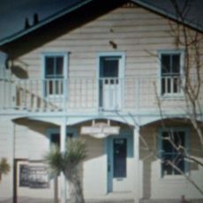
Phonehenge West was an art installation in Acton built from a 70-foot tower and 13 interconnected structures made mostly from reclaimed telephone poles and recycled movie set materials. The complex integrated various elements including colored glass windows and a working windmill.

Alan Kimble Fahey, a retired phone company technician, spent three decades building this complex before authorities demolished it in 2011. The removal occurred due to violations of local building codes.

The structures showed a mix of handmade creativity and artistic ideas, with colored glass windows and surprising details that revealed how one person could reimagine forgotten materials.

The site was remote and sat away from main roads in rural Acton. Visitors today can only experience the location through archived photos and documented accounts rather than visiting the physical site.

A staircase on the property came from actor Danny DeVito, showing how the site attracted notable supporters from beyond the local area. This highlights how unusual art projects can draw attention and donations from unexpected sources.

The community of curious travelers

AroundUs brings together thousands of curated places, local tips, and hidden gems, enriched daily by 60,000 contributors worldwide.

Start exploring
GPS coordinates
34.52453,-118.23656
Latest update
December 13, 2025 12:40
Around this place
Golden Oak Ranch
United States of America

Golden Oak Ranch

27.8 km
Antelope Valley California Poppy Reserve State Natural Reserve
United States of America

Antelope Valley California Poppy Reserve State Natural Reserve

26.9 km
Shambala Preserve
United States of America

Shambala Preserve

9.5 km
Scaled Composites Triumph
United States of America

Scaled Composites Triumph

16.1 km
Mount Lukens, California
United States of America

Mount Lukens, California

28.4 km
Joe Davies Heritage Airpark
United States of America

Joe Davies Heritage Airpark

16.1 km
Placerita Canyon State Park
United States of America

Placerita Canyon State Park

25.4 km
Soledad Canyon
United States of America

Soledad Canyon

30.1 km
Shea's Castle
United States of America

Shea's Castle

24.1 km
Saugus Speedway
United States of America

Saugus Speedway

29.3 km
Bouquet Reservoir
United States of America

Bouquet Reservoir

14.6 km
Big Tujunga Dam
United States of America

Big Tujunga Dam

26.1 km
Pacoima Dam
United States of America

Pacoima Dam

25.7 km
Dry Town Water Park
United States of America

Dry Town Water Park

16.6 km
Littlerock Dam
United States of America

Littlerock Dam

20.2 km
Strawberry Peak
United States of America

Strawberry Peak

28.9 km
Dry Canyon Reservoir
United States of America

Dry Canyon Reservoir

27.2 km
Fairmont Butte
United States of America

Fairmont Butte

29.5 km
Western Hotel
United States of America

Western Hotel

21.3 km
Willow Springs Canyon
United States of America

Willow Springs Canyon

23.3 km
Vasquez Rocks
United States of America

Vasquez Rocks

8.9 km
Blackbird Airpark
United States of America

Blackbird Airpark

16.3 km
Moah:cedar
United States of America

Moah:cedar

21.2 km
Elyze Clifford Interpretive Center
United States of America

Elyze Clifford Interpretive Center

16.4 km
Blackbird Airpark
United States of America

Blackbird Airpark

16.3 km
Vasquez Rocks Park
United States of America

Vasquez Rocks Park

8.9 km
Armstrong Aircraft Operations Facility
United States of America

Armstrong Aircraft Operations Facility

17.6 km
Nature Center [Placerita State Park]
United States of America

Nature Center [Placerita State Park]

26.7 km
Show the full map
Reviews
Share your experience

No review yet

Discussions
Start a discussion...

No discussion yet

« Phonehenge West - Folk art installation in Acton, Los Angeles County, US » is provided by Around Us (aroundus.com). Images and texts are derived from Wikimedia project under a Creative Commons license. You are allowed to copy, distribute, and modify copies of this page, under the conditions set by the license, as long as this note is clearly visible.

Discover hidden gems everywhere you go!

From secret cafés to breathtaking viewpoints, skip the crowded tourist spots and find places that match your style. Our app makes it easy with voice search, smart filtering, route optimization, and insider tips from travelers worldwide. Download now for the complete mobile experience.

Around Us App Screenshot

A unique approach to discovering new places

Le Figaro

All the places worth exploring

France Info

A tailor-made excursion in just a few clicks

20 Minutes

Around Us
Travel Guide & Maps
Download

Send to your phone

QR Code
1

Open the camera app on your mobile.

2

Point at the QR code with your camera. A notification will appear.

3

Tap the notification to open the link.