Chest opened
+${chestReward.xp} XP
Explorer
NOUVEAU ×${chestReward.collectible.quantity}
tapez pour fermer
Chest locked

Open chests in the app

Around Us is built for your phone — chests unlock when you walk, explore and capture nearby places.

Enable Location

We need your location to show you interesting places around you

Discover nearby places

Find interesting locations and hidden gems around you

Precise directions

Get accurate directions and distances to places

Your location is never shared with other users. It's only used when you tap the location button.

Cedarville

Log in to your account

Start exploring — it's free

Trusted by 72,891 travelers worldwide

Continue with Google
Continue with Apple
or

We will send you a code to connect

By continuing, you accept our Terms and Conditions and our Privacy Policy

Check your inbox

We've sent a pincode in your inbox. Please enter the code below.

Discussion Reviews 1 Photos
11.6k Popularity

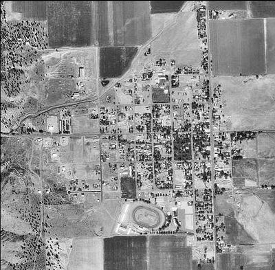
Cedarville, Census-designated place in Modoc County, United States

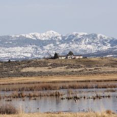
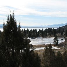
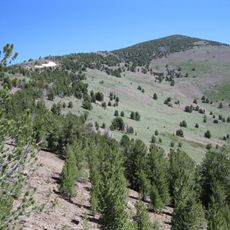
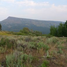
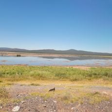
Cedarville is located at 1,418 meters elevation in northeastern California within Surprise Valley, positioned near the western shore of Middle Alkali Lake and at the base of the Warner Mountains. The settlement sits in a high-altitude valley surrounded by mountain terrain and lake features.

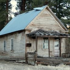
The settlement began in 1864 as a stopping place for wagon trains crossing the region, and received its first post office in 1869. It grew to become the largest town in Surprise Valley during the period of westward expansion.

The Cressler and Bonner Trading Post, operating since 1865, served as a vital stopping point for people traveling west across the region. It reflects how the settlement functioned as a crossroads for commerce and movement through the valley.

The community is served by Surprise Valley Joint Unified School District offering elementary and high school education to residents. Visitors should be aware that the high elevation means winters can be cold and snowy with limited road access during severe weather.

Bonner Grade, located about 6 miles west on California State Route 299, was the first road connection between this place and Alturas. This pass became essential for linking settlements across the remote county.

The community of curious travelers

AroundUs brings together thousands of curated places, local tips, and hidden gems, enriched daily by 60,000 contributors worldwide.

Start exploring
Location
Elevation above the sea
1,418 m
GPS coordinates
41.52917,-120.17333
Latest update
December 7, 2025 20:49
Around this place
Fly Geyser
United States of America

Fly Geyser

102.6 km
Modoc National Forest
United States of America

Modoc National Forest

88.3 km
Sheldon National Wildlife Refuge
United States of America

Sheldon National Wildlife Refuge

81.5 km
Clear Lake National Wildlife Refuge
United States of America

Clear Lake National Wildlife Refuge

86.3 km
South Warner Wilderness
United States of America

South Warner Wilderness

21.8 km
Modoc National Wildlife Refuge
United States of America

Modoc National Wildlife Refuge

29.9 km
Abert Rim
United States of America

Abert Rim

95.8 km
David L. Shirk Ranch
United States of America

David L. Shirk Ranch

95.7 km
Fandango Pass
United States of America

Fandango Pass

30.5 km
Greaser Petroglyph Site
United States of America

Greaser Petroglyph Site

78.8 km
Eagle Peak
United States of America

Eagle Peak

27.4 km
Goose Lake State Recreation Area
United States of America

Goose Lake State Recreation Area

53.2 km
Chandler State Wayside
United States of America

Chandler State Wayside

98.2 km
High Rock Canyon Wilderness
United States of America

High Rock Canyon Wilderness

62 km
Hunter's Hot Springs
United States of America

Hunter's Hot Springs

78.7 km
Stone Bridge and the Oregon Central Military Wagon Road
United States of America

Stone Bridge and the Oregon Central Military Wagon Road

96 km
Booth State Scenic Corridor
United States of America

Booth State Scenic Corridor

80.9 km
Goose Lake meteorite
United States of America

Goose Lake meteorite

58.8 km
Dodge Reservoir
United States of America

Dodge Reservoir

62.5 km
Hat Mountain
United States of America

Hat Mountain

42.5 km
Deep Creek Falls
United States of America

Deep Creek Falls

74.1 km
Lake County Round Sale Barn
United States of America

Lake County Round Sale Barn

75.8 km
John N. and Cornelia Watson House
United States of America

John N. and Cornelia Watson House

74.9 km
Jess Valley Schoolhouse
United States of America

Jess Valley Schoolhouse

31.4 km
William P. Heryford House
United States of America

William P. Heryford House

74.8 km
Alger Theatre
United States of America

Alger Theatre

74.8 km
Niles Theater
United States of America

Niles Theater

31.2 km
Sandy Beach
United States of America

Sandy Beach

106.3 km
Show the full map
Reviews
Share your experience

No review yet

Discussions
Start a discussion...

No discussion yet

« Cedarville - Census-designated place in Modoc County, United States » is provided by Around Us (aroundus.com). Images and texts are derived from Wikimedia project under a Creative Commons license. You are allowed to copy, distribute, and modify copies of this page, under the conditions set by the license, as long as this note is clearly visible.

Discover hidden gems everywhere you go!

From secret cafés to breathtaking viewpoints, skip the crowded tourist spots and find places that match your style. Our app makes it easy with voice search, smart filtering, route optimization, and insider tips from travelers worldwide. Download now for the complete mobile experience.

Around Us App Screenshot

A unique approach to discovering new places

Le Figaro

All the places worth exploring

France Info

A tailor-made excursion in just a few clicks

20 Minutes

Around Us
Travel Guide & Maps
Download

Send to your phone

QR Code
1

Open the camera app on your mobile.

2

Point at the QR code with your camera. A notification will appear.

3

Tap the notification to open the link.