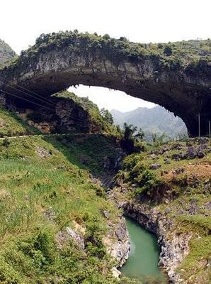
Xianren Bridge, Natural limestone arch in Guangxi Province, China
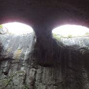
The natural arch spans 121.9 meters across the Buliu River, making it the longest natural arch span measured and documented in the world.
The Natural Arch and Bridge Society conducted measurements of the formation in October 2010, following its initial discovery through Google Earth in 2009.
Local residents refer to the structure as Fairy Bridge, reflecting Chinese traditions of connecting natural formations with supernatural or mythological elements.
Visitors need to arrange a three-hour rafting expedition on the Buliu River to reach this natural formation in the northern region of Guangxi.
The limestone arch remained unknown to researchers until 2009, despite its record-breaking span that surpasses Utah's Landscape Arch by over 30 meters.
GPS coordinates: 24.68770,106.80000
Latest update: May 25, 2025 10:25
Geological forces have carved openings, arches, and caves into rock formations across continents through millions of years of erosion. Water, wind, and weathering have shaped these natural structures from various rock types, creating landmarks that reveal the Earth's ongoing transformation. The formations appear in diverse environments, from coastlines where ocean waves carve passages through limestone cliffs to desert regions where wind erosion creates openings in sandstone walls. This collection spans locations such as Durdle Door along England's Jurassic Coast, where a 200-foot (60-meter) arch rises from layers dating to the Mesozoic era. The Faraglioni Rocks off Capri reach heights of 360 feet (109 meters) and include a natural passage navigable by boat. In landlocked regions, formations like the Eyes of God in Bulgaria's Prohodna Cave display symmetrical ceiling openings where sunlight penetrates the rock. Desert sites such as Las Ventanas in Argentina's Andes showcase wind-carved arches in remote sandstone landscapes. Each location offers direct evidence of erosion processes that continue shaping these geological features, from readily accessible coastal points to isolated areas requiring significant travel to reach.
Five-hundred-meter Aperture Spherical Telescope
107.6 km
Ban Gioc–Detian Falls
204 km
Huangguoshu Waterfall
184.7 km
South China Karst
132.6 km
Beipan River Guanxing Highway Bridge
154.8 km
Baling River Bridge
184.3 km
Pingtang Bridge
125 km
Guiyang Olympic Sports Center
216.1 km
牡宜遗址
197.8 km
Nguom Ngao Cave
205.3 km
Tra Linh checkpoint
207.8 km
24-zig
204.5 km
Beipan River Hukun Expressway Bridge
200.6 km
Jiaxiu Pavilion
210.3 km
Wenchang Pavilion
211.1 km
Wang Yangming Memorial Temple
211.6 km
Hongfu Temple
213.1 km
Longbang Port
207.7 km
Qinglong Railway Bridge
209.6 km
Yantan Dam
102 km
Yunshantun
192.6 km
侬氏土司衙署
189.8 km
Tiantaishan Wulong Temple
197.3 km
Anshun Confucian Temple
194.8 km
Malinghe River Bridge
194.6 km
Former Residence of Wang Ruofei
195.1 km
Temple of Guan Yu
198 km
Red Flag Lake (Zhenning County)
186.5 kmReviews
Visited this place? Tap the stars to rate it and share your experience / photos with the community! Try now! You can cancel it anytime.
Discover hidden gems everywhere you go!
From secret cafés to breathtaking viewpoints, skip the crowded tourist spots and find places that match your style. Our app makes it easy with voice search, smart filtering, route optimization, and insider tips from travelers worldwide. Download now for the complete mobile experience.
A unique approach to discovering new places❞
— Le Figaro
All the places worth exploring❞
— France Info
A tailor-made excursion in just a few clicks❞
— 20 Minutes