Ellingwood Point

Log in to your account

AroundUs is a community-driven map of interesting places, built by curious explorers like you. It grows with every review, story, and photo you share.
Connect to save your favorite spots, contribute locations, and create personalized routes.
Continue with Google
Continue with Apple
Continue with X
Continue with Facebook
Continue with email
By continuing, you accept our Terms and Conditions and our Privacy Policy
Create an account
Add to collection
Map
Suggest a change
Share

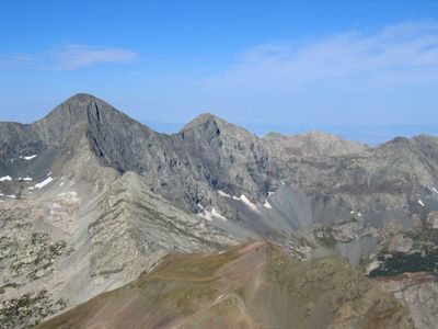
Ellingwood Point, Summit and mountain peak in Sangre de Cristo Range, Colorado.

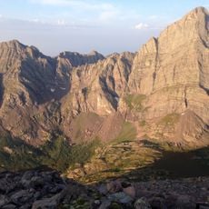
Ellingwood Point is a mountain in the Sangre de Cristo Range located between Alamosa and Huerfano Counties in Colorado. The peak rises to 14,048 feet (4,282 meters) and forms a prominent part of the Sierra Blanca Massif.

The mountain was named after Albert Russell Ellingwood, a climber who pioneered advanced climbing techniques in Colorado. His influence on alpinism in the region helped establish many climbing standards that are still used today.

The peak stands as a recognized fourteener destination within Colorado's mountaineering community, requiring specific climbing skills and physical preparation.

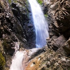
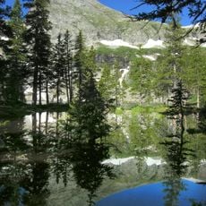
Access begins at the Lily Lake Trailhead, which connects to routes varying in difficulty across the mountain. Visitors should bring proper gear and expect steep terrain that requires climbing experience.

The summit marks a water divide where two national forests meet, separating the Rio Grande National Forest from San Isabel National Forest. This location creates a boundary point that hikers often find surprising.

Location: Alamosa County

Location: Huerfano County

GPS coordinates: 37.58259,-105.49255

Latest update: December 12, 2025 14:20

Photos
Around this place
Blanca Peak
United States of America

Blanca Peak

831 m
Zapata Falls
United States of America

Zapata Falls

6.7 km
Rio Grande Scenic Railroad
United States of America

Rio Grande Scenic Railroad

35.3 km
North La Veta Pass
United States of America

North La Veta Pass

27 km
UFO Watchtower
United States of America

UFO Watchtower

41.6 km
Fort Garland
United States of America

Fort Garland

18.4 km
Little Bear Peak
United States of America

Little Bear Peak

1.8 km
Mount Lindsey
United States of America

Mount Lindsey

4.2 km
Baca National Wildlife Refuge
United States of America

Baca National Wildlife Refuge

41.6 km
Alamosa National Wildlife Refuge
United States of America

Alamosa National Wildlife Refuge

31.6 km
Mount Mestas
United States of America

Mount Mestas

30.5 km
Pike's Stockade
United States of America

Pike's Stockade

42.7 km
D&RGW 169
United States of America

D&RGW 169

35 km
Closed Basin Project
United States of America

Closed Basin Project

16.4 km
United States of America

Iron Mountain

21.9 km
Montoya Ranch
United States of America

Montoya Ranch

41.3 km
St. Thomas Episcopal Church
United States of America

St. Thomas Episcopal Church

35.3 km
Broken Hand Peak
United States of America

Broken Hand Peak

42.2 km
Trujillo Homestead
United States of America

Trujillo Homestead

27.2 km
American National Bank Building
United States of America

American National Bank Building

35.2 km
Superintendent's Residence, Great Sand Dunes National Monument
United States of America

Superintendent's Residence, Great Sand Dunes National Monument

16 km
San Luis Southern Railway Trestle
United States of America

San Luis Southern Railway Trestle

22.3 km
Alamosa County Courthouse
United States of America

Alamosa County Courthouse

35.4 km
Husung Hardware
United States of America

Husung Hardware

35.3 km
Upper Sand Creek Lake
United States of America

Upper Sand Creek Lake

39.9 km
Big Spring Creek
United States of America

Big Spring Creek

23.6 km
Medano Ranch Headquarters
United States of America

Medano Ranch Headquarters

22.3 km
Lower Sand Creek Lake
United States of America

Lower Sand Creek Lake

38.8 km
Show the full map
Reviews

Visited this place? Tap the stars to rate it and share your experience / photos with the community! Try now! You can cancel it anytime.

« Ellingwood Point - Summit and mountain peak in Sangre de Cristo Range, Colorado » is provided by Around Us (aroundus.com). Images and texts are derived from Wikimedia project under a Creative Commons license. You are allowed to copy, distribute, and modify copies of this page, under the conditions set by the license, as long as this note is clearly visible.

Discover hidden gems everywhere you go!

From secret cafés to breathtaking viewpoints, skip the crowded tourist spots and find places that match your style. Our app makes it easy with voice search, smart filtering, route optimization, and insider tips from travelers worldwide. Download now for the complete mobile experience.

Around Us App Screenshot

A unique approach to discovering new places

Le Figaro

All the places worth exploring

France Info

A tailor-made excursion in just a few clicks

20 Minutes